1970s Maps of Ravalli County, Montana
Explore 19 historic maps of Ravalli County from the 1970s. These maps offer a rare glimpse into what life looked like during the 1970s — showing old roads, neighborhoods, homes, and landmarks that have changed or disappeared over time.
Whether you're researching your family's past, planning a metal detecting trip, or studying how Ravalli County's landscape evolved across the 1970s, these high-resolution maps are a powerful tool for exploring the history of this region.
- Focus on a specific era: All maps on this page are from the 1970s, giving you a focused view of this time period.
- See what’s changed: Compare century-old streets, trails, and buildings to today's modern landscape using overlays and satellite layers.
- Research with precision: Use these maps for genealogy, historical research, land use analysis, or educational projects.
- View, download, or print: Maps are fully viewable online in high resolution, and can be downloaded or printed for your own records.
Start exploring Ravalli County's history through authentic maps from the 1970s. This is your window into the past.
Ravalli County, MT maps
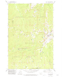
(19)- 1971 Map of Stony Creek, 1974 Print
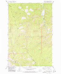
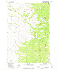
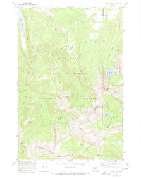 1971 Stony Creek1974 Print · USGSThe Anaconda-Pintlar Wilderness and the high Continental Divide are captured here in the early 1970s. Researchers can trace historic access routes via Pack Trails to remote sites like the Sunshine Mine, Storm Lake, and One Hundred Acre Meadow.
 - 1974 Map of Stony Creek, 1977 Print
 1974 Stony Creek1977 Print · USGSHigh-elevation Montana forests and the Granite County line are documented in the mid-1970s. Trace old backcountry access routes along Stony Creek or locate remote landmarks like Stony Lake and the Windlass Bridge over Rock Creek.
 - 1974 Map of Skalkaho Pass, 1977 Print
 1974 Skalkaho Pass1977 Print · USGSHigh in the Sapphire Mountains during the mid-seventies, this survey captures the meeting point of two national forests and two counties. Trace the historic Pack Trail past Signal Rock, Mud Lake, and local Prospects along the continental divide.2 unique versions available
 - 1974 Map of Burnt Fork Lake, 1977 Print
 1974 Burnt Fork Lake1977 Print · USGSHigh in the Bitterroot Mountains during the mid-seventies, this survey shows the remote convergence of three national forests. Researchers can trace historic Pack Trails leading to Skalkaho Falls, Burnt Lake, and Kneaves Lake.2 unique versions available
 - 1974 Map of Whetstone Ridge, 1977 Print
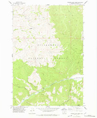
 1974 Whetstone Ridge1977 Print · USGSHigh in the Bitterroot and Deerlodge national forests during the 1970s, this area was a hub of prospecting and high-altitude pack trails. Trace the locations of historic claims like Montana Prince Mine and Millers Mine near the heights of Whetstone Ridge.
 - 1974 Map of Gird Point, 1977 Print
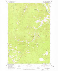
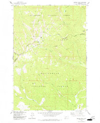
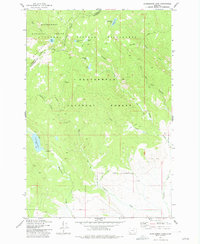
 1974 Gird Point1977 Print · USGSRavalli County's high forest terrain is captured here in the mid-1970s, showing a landscape of federal management and remote mountain access. Researchers can trace forest history through the Black Bear Forest Service Station, Yellowstone Camp, and the winding Skalkaho Creek.
 - 1974 Map of Kent Peak, 1977 Print
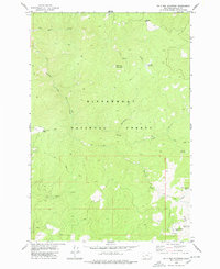
 1974 Kent Peak1977 Print · USGSHigh in the Sapphire Mountains during the mid-seventies, this survey maps the boundary between Ravalli and Granite counties. Trace old routes past Lost Tooth Cabin and high-altitude water like Kent Lake and Lake Abundance.
 - 1974 Map of Sawmill Saddle, 1977 Print
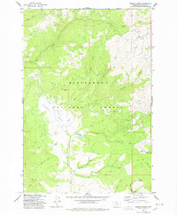
 1974 Sawmill Saddle1977 Print · USGSGranite and Ravalli counties were still primarily wilderness in the mid-1970s, defined by the intersection of national forests. You can trace the remote network of pack trails connecting Sawmill Saddle, Bitterroot Flat Campground, and Eagle Point.
 - 1974 Map of Bender Point, 1977 Print
 1974 Bender Point1977 Print · USGSThe high country of the Beaverhead and Ravalli county line is documented here in the mid-1970s. Trace the path of the Continental Divide and find remote alpine features like Carmine Lake and Bender Point.2 unique versions available
 - 1974 Map of Lick Creek, 1977 Print
 1974 Lick Creek1977 Print · USGSHigh in the Bitterroot range during the mid-seventies, this area shows the convergence of national forest lands and wilderness. Trace the remote Pack Trails used by foresters and hunters, and locate early landmarks like the East Fork Forest Service Station and Lookout Tower.2 unique versions available
 - 1977 Map of Sula
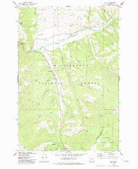 1977 Sula1977 Print · USGSThe Bitterroot Valley south of Hamilton comes into focus in the 1970s, showcasing the high-country transition from Ross Hole to the Continental Divide. Researchers can trace family sites near Sula, locate the Sula Cem, and follow the Bitterroot River headwaters.2 unique versions available
 - 1977 Map of Kelly Lake
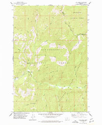
 1977 Kelly Lake1977 Print · USGSThe Anaconda Range and the surrounding national forests are captured here in the 1970s, showcasing a high-altitude landscape where four Montana counties meet. Outdoor researchers and historians can trace high-country paths like the Alpine Trail to remote landmarks such as the Senate Mine, Pintlar Peak, and Star Falls.3 unique versions available
 - 1977 Map of Mussigbrod Lake
 1977 Mussigbrod Lake1977 Print · USGSBeaverhead County alpine wilderness is documented here in the late seventies, showing the meeting of national forests at the Continental Divide. Trace the remote pack trails connecting Mussigbrod Lake, Mystic Lake, and the Forest Service Station.2 unique versions available
 - 1977 Map of Jennings Camp Creek, 1978 Print
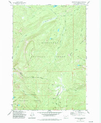
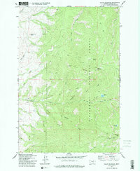
 1977 Jennings Camp Creek1978 Print · USGSRavalli County’s high country is captured here in the late seventies, showing the remote drainages of the Bitterroot National Forest. Outdoor historians and researchers can trace the routes of Pack Trails, locate old Prospects, or find the LANDING STRIP near the East Fork Bitterroot River.
 - 1977 Map of Schultz Saddle, 1978 Print
 1977 Schultz Saddle1978 Print · USGSThe high Montana wilderness along the Continental Divide is mapped here in the late seventies. You can trace early backcountry access routes via Pack Trail and Jeep Trail networks near Schultz Saddle and Tolan Ridge.
 - 1977 Map of Willow Mountain, 1978 Print
 1977 Willow Mountain1978 Print · USGSThe Sapphire Mountains in the late seventies were a realm of remote peaks and forest service lookouts. Modern researchers can trace high-altitude water sources like Fool Hen Lake or locate old industrial activity at the Mine and Willow Mountain Lookout.2 unique versions available
 - 1977 Map of Corley Gulch, 1978 Print
 1977 Corley Gulch1978 Print · USGSThe eastern slopes of the Bitterroot Valley are shown here in the 1970s, as ranching irrigation met the forest boundary. Trace the historic Claremont Trail or locate remote sites like the Gold Creek Campground and the Prospect near Squaw Peak.
 - 1978 Map of Bald Top Mountain
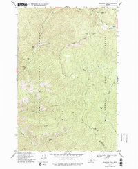
 1978 Bald Top Mountain1978 Print · USGSRavalli County high country in the late seventies is shown here as a landscape of remote mountain camps and active mineral exploration. Follow old pack trails to find Crystal Mountain Mine or secluded clearings like Two Bear Meadows.
 - 1978 Map of French Basin
 1978 French Basin1978 Print · USGSWestern Montana in the late 1970s is documented here through its dense network of mountain drainages and forest service landmarks. Researchers can trace historical water sources like Schoolmarm Lake and Clough Springs or identify family-named points such as Shirley Mountain.
End of results
Showing maps 1-19 of 19
Top cities of Ravalli County
- Hamilton historical maps
- Stevensville historical maps
- Darby historical maps
- Pinesdale historical maps
- Victor historical maps
Frequently asked questions
- What are the different types of historical maps available for Ravalli County?
- What is the oldest map of Ravalli County?
- Where can I purchase historical maps of Ravalli County for my home or office?
- Where can I download high-res historical maps of Ravalli County?
- Are there historical topographic maps available for Ravalli County?
- Is there historical aerial imagery available for Ravalli County?
- Where are historical maps of Ravalli County sourced from?