1970s Maps of Sheridan County, Montana
Explore 4 historic maps of Sheridan County from the 1970s. These maps offer a rare glimpse into what life looked like during the 1970s — showing old roads, neighborhoods, homes, and landmarks that have changed or disappeared over time.
Whether you're researching your family's past, planning a metal detecting trip, or studying how Sheridan County's landscape evolved across the 1970s, these high-resolution maps are a powerful tool for exploring the history of this region.
- Focus on a specific era: All maps on this page are from the 1970s, giving you a focused view of this time period.
- See what’s changed: Compare century-old streets, trails, and buildings to today's modern landscape using overlays and satellite layers.
- Research with precision: Use these maps for genealogy, historical research, land use analysis, or educational projects.
- View, download, or print: Maps are fully viewable online in high resolution, and can be downloaded or printed for your own records.
Start exploring Sheridan County's history through authentic maps from the 1970s. This is your window into the past.
Sheridan County, MT maps
(4)- 1973 Map of Navajo, 1976 Print
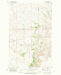 1973 Navajo1976 Print · USGSEastern Montana ranchlands in the early 1970s are centered here on the small settlement of Navajo. You can trace the Burlington Northern railroad as it winds past Eagles Nest and the headwaters of Eagle Creek.
 - 1973 Map of Goodale Coulee, 1976 Print
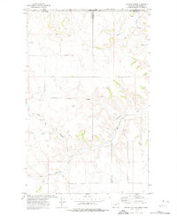 1973 Goodale Coulee1976 Print · USGSThe international borderlands of Daniels County are captured here in the early seventies, showcasing a high plains agricultural landscape. Researchers can trace the Soo Line railroad route and locate rural landmarks like Storage Bins and the Well Drill Hole.
 - 1973 Map of Pleasant Prairie NE, 1977 Print
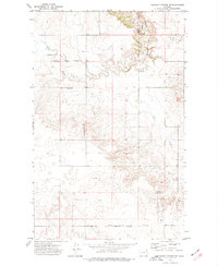 1973 Pleasant Prairie NE1977 Print · USGSNortheast Montana at the beginning of the 1970s shows a landscape of wide-open ranching country and tribal lands. Researchers can locate the Fort Peck Indian Reservation Boundary, the community gathering point at Wolf Creek Hall, and several Storage Bins scattered near Eagle Creek.
 - 1974 Map of Brush Mountain, 1977 Print
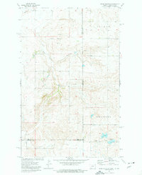 1974 Brush Mountain1977 Print · USGSThe high plains of the Montana and North Dakota border are captured here during the mid-seventies, showing a landscape of remote drainage basins and rural homesteads. Genealogists can locate family landmarks such as Scandia Ch and the neighboring Cem, or trace the path of Dead Horse Spring.2 unique versions available
End of results
Showing maps 1-4 of 4
Top cities of Sheridan County
- Plentywood historical maps
- Medicine Lake historical maps
- Westby historical maps
- Outlook historical maps
Frequently asked questions
- What are the different types of historical maps available for Sheridan County?
- What is the oldest map of Sheridan County?
- Where can I purchase historical maps of Sheridan County for my home or office?
- Where can I download high-res historical maps of Sheridan County?
- Are there historical topographic maps available for Sheridan County?
- Is there historical aerial imagery available for Sheridan County?
- Where are historical maps of Sheridan County sourced from?