1960s Maps of Banner County, Nebraska
Explore 5 historic maps of Banner County from the 1960s. These maps offer a rare glimpse into what life looked like during the 1960s — showing old roads, neighborhoods, homes, and landmarks that have changed or disappeared over time.
Whether you're researching your family's past, planning a metal detecting trip, or studying how Banner County's landscape evolved across the 1960s, these high-resolution maps are a powerful tool for exploring the history of this region.
- Focus on a specific era: All maps on this page are from the 1960s, giving you a focused view of this time period.
- See what’s changed: Compare century-old streets, trails, and buildings to today's modern landscape using overlays and satellite layers.
- Research with precision: Use these maps for genealogy, historical research, land use analysis, or educational projects.
- View, download, or print: Maps are fully viewable online in high resolution, and can be downloaded or printed for your own records.
Start exploring Banner County's history through authentic maps from the 1960s. This is your window into the past.
Banner County, NE maps
(5)- 1960 Map of Tremain
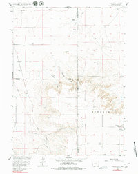 1960 Tremain1960 Print · USGSThe high plains of the Wyoming-Nebraska border come into focus in 1960, showing a landscape defined by cattle ranching and rail infrastructure. Researchers can trace historic family-named homesteads like Bull Canyon Ranch and Spahr Ranch alongside the Epworth Cem.3 unique versions available
 - 1960 Map of Mc Compsey Pass, 1962 Print
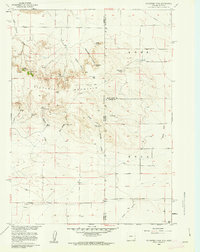 1960 Mc Compsey Pass1962 Print · USGSThe Wyoming-Nebraska borderlands in the early sixties reveal a landscape defined by isolated ranches and essential water sources. Trace the movement of livestock and early settlers through Mc Compsey Pass, the Spahr Ranch, and remote landmarks like Devils Armchair.3 unique versions available
 - 1960 Map of Murray Lake, 1962 Print
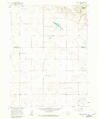 1960 Murray Lake1962 Print · USGSThe high plains of Banner County and Scotts Bluff County are captured here in the early 1960s, showing a landscape of deep canyons and isolated homesteads. Genealogists and local historians can trace the Stegall South Road to the Pleasant Hill Cem or locate seasonal water at Murray Lake.2 unique versions available
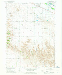
 - 1965 Map of South Bayard, 1967 Print
 1965 South Bayard1967 Print · USGSMorrill County and the North Platte River valley are captured here in the mid-1960s, a landscape defined by pioneer history and modern irrigation. You can trace the path of the Emigrant Trail past Chimney Rock and locate rural landmarks like School No 50 and Facus Springs.
 - 1965 Map of McGrew, 1967 Print
 1965 McGrew1967 Print · USGSThe North Platte River valley in the mid-1960s highlights the vital rail-and-water infrastructure of western Nebraska. Researchers can trace historic landmarks like High Butte Cem or navigate the gaps of the Wrights range through Williams Gap and Hubbard Gap.
End of results
Showing maps 1-5 of 5
Top cities of Banner County
Frequently asked questions
- What are the different types of historical maps available for Banner County?
- What is the oldest map of Banner County?
- Where can I purchase historical maps of Banner County for my home or office?
- Where can I download high-res historical maps of Banner County?
- Are there historical topographic maps available for Banner County?
- Is there historical aerial imagery available for Banner County?
- Where are historical maps of Banner County sourced from?