1990s Maps of Banner County, Nebraska
Explore 3 historic maps of Banner County from the 1990s. These maps offer a rare glimpse into what life looked like during the 1990s — showing old roads, neighborhoods, homes, and landmarks that have changed or disappeared over time.
Whether you're researching your family's past, planning a metal detecting trip, or studying how Banner County's landscape evolved across the 1990s, these high-resolution maps are a powerful tool for exploring the history of this region.
- Focus on a specific era: All maps on this page are from the 1990s, giving you a focused view of this time period.
- See what’s changed: Compare century-old streets, trails, and buildings to today's modern landscape using overlays and satellite layers.
- Research with precision: Use these maps for genealogy, historical research, land use analysis, or educational projects.
- View, download, or print: Maps are fully viewable online in high resolution, and can be downloaded or printed for your own records.
Start exploring Banner County's history through authentic maps from the 1990s. This is your window into the past.
Banner County, NE maps
(3)- 1990 Map of Tremain, 1995 Print
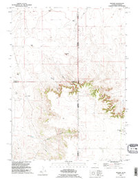 1990 Tremain1995 Print · USGSThe Wyoming and Nebraska borderlands are captured here in the 1990s as a landscape of isolated family ranches and deep canyons. Researchers can locate long-standing sites like Tremain Ranch, the Epworth Cem, and the prominent Ninemile Rock.
 - 1990 Map of Mc Compsey Pass, 1995 Print
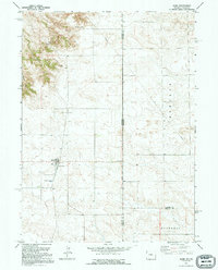
 1990 Mc Compsey Pass1995 Print · USGSThe Wyoming and Nebraska high plains are captured here in the 1990s, showcasing a landscape of ridge-top passes and essential cattle-country water sources. Trace family ranching roots through Spahr Ranch or locate named landmarks like McCompsey Pass and Devils Armchair.
 - 1991 Map of Albin, 1995 Print
 1991 Albin1995 Print · USGSThe tri-county border of Wyoming and Nebraska comes into focus during the early nineties, centered on the plains community of Albin. Researchers can trace local landmarks like Albin Cem and Blair Hill or follow the path of State Line Road into Bushnell.
End of results
Showing maps 1-3 of 3
Top cities of Banner County
Frequently asked questions
- What are the different types of historical maps available for Banner County?
- What is the oldest map of Banner County?
- Where can I purchase historical maps of Banner County for my home or office?
- Where can I download high-res historical maps of Banner County?
- Are there historical topographic maps available for Banner County?
- Is there historical aerial imagery available for Banner County?
- Where are historical maps of Banner County sourced from?