1800s (19th Century) Maps of Kearney, Nebraska
Explore 2 historic maps of Kearney from the 1800s (19th Century). These maps offer a rare glimpse into what life looked like during the 1800s — showing old roads, neighborhoods, homes, and landmarks that have changed or disappeared over time.
Whether you're researching your family's past, planning a metal detecting trip, or studying how Kearney's landscape evolved across the 1800s, these high-resolution maps are a powerful tool for exploring the history of this region.
- Focus on a specific era: All maps on this page are from the 1800s, giving you a focused view of this time period.
- See what’s changed: Compare century-old streets, trails, and buildings to today's modern landscape using overlays and satellite layers.
- Research with precision: Use these maps for genealogy, historical research, land use analysis, or educational projects.
- View, download, or print: Maps are fully viewable online in high resolution, and can be downloaded or printed for your own records.
Start exploring Kearney's history through authentic maps from the 1800s. This is your window into the past.
Kearney, NE maps
(2)- 1894 Map of Kearney
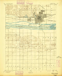 1894 Kearney1894 Print · USGSKearney and the Platte River valley are captured in the late nineteenth century as a vital railroad junction and irrigation center. Genealogists and local historians can trace early settlements like Odessa and West Kearney, or study the complex river channels around Long Island and Evarts Island.2 unique versions available
 - 1896 Map of Kearney
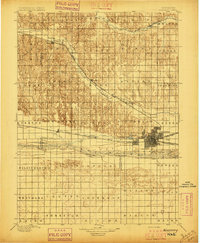 1896 Kearney1896 Print · USGSBuffalo County and the Platte River valley are captured in the late 1890s as the railroad network cemented the region's growth. Genealogists can locate family lands across townships like Williamsburg or trace the early paths of the Union Pacific R. R. and Kearney Canal.7 unique versions available
End of results
Showing maps 1-2 of 2
Top cities near Kearney
- Minden historical maps
- Gibbon historical maps
- Axtell historical maps
- Odessa historical maps
- Amherst historical maps
- Newark historical maps
See more
Top neighborhoods of Kearney
- East Lawn Mobile Home Estates historical maps
- Riverside Mobile Home Court historical maps
- Valley View Trailer Court historical maps
- R-Villa Courts historical maps
Frequently asked questions
- What are the different types of historical maps available for Kearney?
- What is the oldest map of Kearney?
- Where can I purchase historical maps of Kearney for my home or office?
- Where can I download high-res historical maps of Kearney?
- Are there historical topographic maps available for Kearney?
- Is there historical aerial imagery available for Kearney?
- Where are historical maps of Kearney sourced from?