1970s Maps of Imperial, Nebraska
Explore 5 historic maps of Imperial from the 1970s. These maps offer a rare glimpse into what life looked like during the 1970s — showing old roads, neighborhoods, homes, and landmarks that have changed or disappeared over time.
Whether you're researching your family's past, planning a metal detecting trip, or studying how Imperial's landscape evolved across the 1970s, these high-resolution maps are a powerful tool for exploring the history of this region.
- Focus on a specific era: All maps on this page are from the 1970s, giving you a focused view of this time period.
- See what’s changed: Compare century-old streets, trails, and buildings to today's modern landscape using overlays and satellite layers.
- Research with precision: Use these maps for genealogy, historical research, land use analysis, or educational projects.
- View, download, or print: Maps are fully viewable online in high resolution, and can be downloaded or printed for your own records.
Start exploring Imperial's history through authentic maps from the 1970s. This is your window into the past.
Imperial, NE maps
(5)- 1973 Map of Champion, 1977 Print
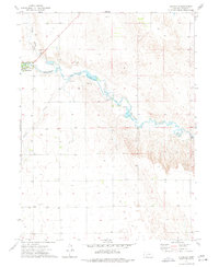 1973 Champion1977 Print · USGSChase County, Nebraska, comes into focus in the mid-1970s as agricultural life centers around the waters of Frenchman Creek. Researchers can trace the local landscape through the Zion Cem, the village of Champion, and the Imperial Powerplant.
 - 1973 Map of Imperial, 1977 Print
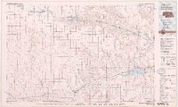
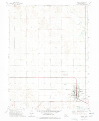 1973 Imperial1977 Print · USGSImperial and the surrounding Chase County plains are captured in the early 1970s, showing the community's growth as a prairie agricultural hub. Genealogists and local historians can trace the town grid, find the Mount Hope Cem, and see the early layout of the Imperial Municipal Airport.
 - 1973 Map of Imperial Municipal Airport, 1977 Print
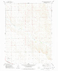 1973 Imperial Municipal Airport1977 Print · USGSChase County, Nebraska, is documented here in the early seventies, capturing a transition in high plains transportation and land use. Genealogists and historians can trace the Burlington Northern rail line and aviation landmarks like Imperial Municipal Airport and the Smith Landing Strip (East).
 - 1979 Map of Imperial
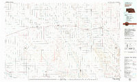 1979 Imperial1979 Print · USGSThe high plains of southwest Nebraska are captured here in the late seventies, showing a landscape defined by rail corridors and creek draws. Genealogists can trace family names and sites through Imperial, Wallace, and Hayes Center, or locate rural landmarks like Arterburn Lake.
 - 1979 Map of Benkelman
 1979 Benkelman1979 Print · USGSSouthwestern Nebraska in the late seventies is shown as a network of river-valley towns and high-plains ranching country. Genealogists and researchers can trace the rail corridor through Benkelman, Culbertson, and Haigler, or locate the reservoir lands at Enders.
End of results
Showing maps 1-5 of 5
Top cities near Imperial
Frequently asked questions
- What are the different types of historical maps available for Imperial?
- What is the oldest map of Imperial?
- Where can I purchase historical maps of Imperial for my home or office?
- Where can I download high-res historical maps of Imperial?
- Are there historical topographic maps available for Imperial?
- Is there historical aerial imagery available for Imperial?
- Where are historical maps of Imperial sourced from?