Old Maps of Crookston, Nebraska
Explore 15 old maps of Crookston, spanning from 1950 to today. These high-resolution historic maps reveal how streets, neighborhoods, landmarks, and natural features evolved over time — perfect for genealogy, metal detecting, research, and local history exploration.
What you can do with these maps:
- See how Crookston changed over time: Compare historical maps to modern-day views to trace roads, homesites, rail lines & more.
- View detailed metadata: Each map includes creators, publishers, year, scale, and archive source.
- Overlay maps with satellite & LiDAR: Visualize the past alongside modern tools to explore terrain & human change.
- Trusted historical sources: Maps sourced from the USGS, Library of Congress, and other archives.
- Access maps your way: View online, download high-res files, or order prints for personal or research use.
Start exploring old maps of Crookston to uncover forgotten places, hidden landmarks, and the deep history beneath your feet.
Crookston, NE maps
(15)- 1950 Map of Kilgore, 1952 Print
 1950 Kilgore1952 Print · USGSSettled along the tracks of the Chicago and North Western, this northern Nebraska landscape is shown at the mid-century point. Genealogists can trace rural family life through scattered schools like School No 10 and prominent sites like Dittmer Ranch.2 unique versions available
 - 1950 Map of Valentine, 1952 Print
 1950 Valentine1952 Print · USGSThe ranching and rail country of Cherry County comes alive in this 1950s record of Valentine and its surrounding prairie. Researchers can locate early one-room schoolhouses like Ward School, family landmarks like Heth Ranch, and the path of the Chicago and North Western railroad.2 unique versions available
 - 1957 Map of Valentine, 1960 Print
 1957 Valentine1960 Print · USGSNorthern Nebraska's ranching country and the vast Sand Hills are detailed here in the late fifties. Genealogists and historians can locate numerous family-named landmarks like the Dahlgren Ranch and trace the path of the Chicago and North Western railroad through Valentine.3 unique versions available
 - 1959 Map of Valentine
 1959 Valentine1959 Print · USGSThe northern Nebraska Sand Hills are captured here in the late fifties, showcasing a vast ranching landscape shaped by the Niobrara and Loup rivers. Genealogists and historians can trace rail-town development along the Chicago and North Western and locate remote outposts like Brownlee or Kennedy.
 - 1983 Map of Crookston East, 1984 Print
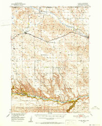
 1983 Crookston East1984 Print · USGSThe Nebraska-South Dakota borderlands are captured here in the early 1980s, centered on the Rosebud Indian Reservation. Researchers can trace the Chicago and North Western railroad as it passes through Crookston and follows the bends of Minnechadua Creek.
 - 1985 Map of Crookston West
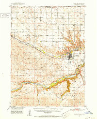
 1985 Crookston West1985 Print · USGSThe Nebraska-South Dakota borderlands in the mid-eighties reveal a sparsely settled landscape of ranching and utility expansion. Genealogists and historians can trace the limits of the Rosebud Indian Reservation Boundary near Crookston and follow the route of Minnechaduza Creek.
 - 1985 Map of Valentine
 1985 Valentine1985 Print · USGSThe Nebraska Sandhills in the mid-1980s reveal a landscape of vast wildlife refuges and rail-linked prairie towns. Researchers can trace the Chicago and North Western corridor through Kilgore and Valentine or locate remote landmarks like Snake River Falls.2 unique versions available
 - 2011 Map of Crookston East, 2011 Print
 2011 Crookston East2011 Print · USGSCovers Crookston, including St. Francis Segment, Antelope Segment, and other nearby areas
 - 2011 Map of Crookston West, 2011 Print
 2011 Crookston West2011 Print · USGSCovers Crookston, including St. Francis Segment, Cherry County, and other nearby areas
 - 2014 Map of Crookston East, 2014 Print
 2014 Crookston East2014 Print · USGSCovers Crookston, including St. Francis Segment, Antelope Segment, and other nearby areas
 - 2014 Map of Crookston West, 2014 Print
 2014 Crookston West2014 Print · USGSCovers Crookston, including St. Francis Segment, Cherry County, and other nearby areas
 - 2017 Map of Crookston East, 2017 Print
 2017 Crookston East2017 Print · USGSCovers Crookston, including St. Francis Segment, Antelope Segment, and other nearby areas
 - 2017 Map of Crookston West, 2017 Print
 2017 Crookston West2017 Print · USGSCovers Crookston, including St. Francis Segment, Cherry County, and other nearby areas
 - 2021 Map of Crookston East, 2021 Print
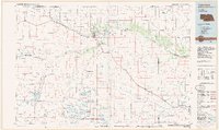
 2021 Crookston East2021 Print · USGSCherry County, Nebraska, is captured here in the early 2020s, showing the intersection of rural ranch land and the South Dakota border. Researchers can trace the path of Minnechaduza Cr or locate local landmarks like Crookston Cem and the Cowboy Trl.
 - 2021 Map of Crookston West, 2021 Print
 2021 Crookston West2021 Print · USGSCrossing the Nebraska-South Dakota border in the modern era, this survey captures the ranching and trail history of Cherry County. Researchers can trace the path of the Cowboy Trail and identify local family-named routes such as ABC Ranch Drive and German Settlement Road.
End of results
Showing maps 1-15 of 15
Top cities near Crookston
Frequently asked questions
- What are the different types of historical maps available for Crookston?
- What is the oldest map of Crookston?
- Where can I purchase historical maps of Crookston for my home or office?
- Where can I download high-res historical maps of Crookston?
- Are there historical topographic maps available for Crookston?
- Is there historical aerial imagery available for Crookston?
- Where are historical maps of Crookston sourced from?