1990s Maps of Omaha, Nebraska
Explore 4 historic maps of Omaha from the 1990s. These maps offer a rare glimpse into what life looked like during the 1990s — showing old roads, neighborhoods, homes, and landmarks that have changed or disappeared over time.
Whether you're researching your family's past, planning a metal detecting trip, or studying how Omaha's landscape evolved across the 1990s, these high-resolution maps are a powerful tool for exploring the history of this region.
- Focus on a specific era: All maps on this page are from the 1990s, giving you a focused view of this time period.
- See what’s changed: Compare century-old streets, trails, and buildings to today's modern landscape using overlays and satellite layers.
- Research with precision: Use these maps for genealogy, historical research, land use analysis, or educational projects.
- View, download, or print: Maps are fully viewable online in high resolution, and can be downloaded or printed for your own records.
Start exploring Omaha's history through authentic maps from the 1990s. This is your window into the past.
Omaha, NE maps
(4)- 1994 Map of Loveland
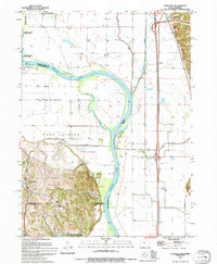 1994 Loveland1994 Print · USGSThe Missouri River floodplain north of Omaha reached a point of high stabilization in the early nineties, managed by a complex network of levees. Genealogists and local historians can trace small communities like Loveland and Nashville, or locate features like the Landing Strip and Boyer Chute.
 - 1994 Map of Council Bluffs North
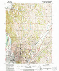 1994 Council Bluffs North1994 Print · USGSCouncil Bluffs and the Missouri River bluffs appear in the 1990s during a period of steady growth and civic development. Genealogists and historians can trace local landmarks like St Marys Cem, the Lewis & Clark Hist Mon, and the Glendale Sch.
 - 1994 Map of Omaha South, 1995 Print
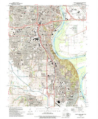 1994 Omaha South1995 Print · USGSOmaha and Bellevue thrive along the Missouri River in the mid-nineties, showing a landscape defined by military aviation and dense neighborhood history. Researchers can trace local roots through numerous sites like St Johns Cem, Rosenblatt Stadium, and the extensive grounds of Offutt Air Force Base.
 - 1994 Map of Omaha North, 1995 Print
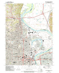 1994 Omaha North1995 Print · USGSThe northern reaches of Omaha and the Missouri River floodplains are captured here in the mid-1990s. Researchers can locate landmark institutions like Creighton University and St Cecilia Cathedral, or trace family roots in the large Forest Lawn Cemetery.
End of results
Showing maps 1-4 of 4
Top cities near Omaha
- Council Bluffs historical maps
- Bellevue historical maps
- Papillion historical maps
- La Vista historical maps
- Blair historical maps
- Ralston historical maps
See more
Top neighborhoods of Omaha
- Debolt historical maps
- Garden Valley Courts historical maps
- East Omaha historical maps
- Skyline historical maps
- Millard historical maps
- South Omaha historical maps
See more
Frequently asked questions
- What are the different types of historical maps available for Omaha?
- What is the oldest map of Omaha?
- Where can I purchase historical maps of Omaha for my home or office?
- Where can I download high-res historical maps of Omaha?
- Are there historical topographic maps available for Omaha?
- Is there historical aerial imagery available for Omaha?
- Where are historical maps of Omaha sourced from?