1940s Maps of Hyannis, Nebraska
Explore 4 historic maps of Hyannis from the 1940s. These maps offer a rare glimpse into what life looked like during the 1940s — showing old roads, neighborhoods, homes, and landmarks that have changed or disappeared over time.
Whether you're researching your family's past, planning a metal detecting trip, or studying how Hyannis's landscape evolved across the 1940s, these high-resolution maps are a powerful tool for exploring the history of this region.
- Focus on a specific era: All maps on this page are from the 1940s, giving you a focused view of this time period.
- See what’s changed: Compare century-old streets, trails, and buildings to today's modern landscape using overlays and satellite layers.
- Research with precision: Use these maps for genealogy, historical research, land use analysis, or educational projects.
- View, download, or print: Maps are fully viewable online in high resolution, and can be downloaded or printed for your own records.
Start exploring Hyannis's history through authentic maps from the 1940s. This is your window into the past.
Hyannis, NE maps
(4)- 1948 Map of Ashby, 1960 Print
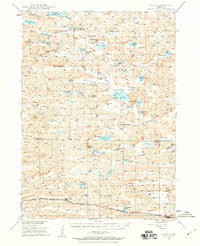 1948 Ashby1960 Print · USGSRanching life in the Nebraska Sandhills is captured here in the late 1940s, highlighting the sprawling cattle operations and alkaline lake systems of the era. Genealogists and historians can trace family holdings like the Egan Ranch or locate the Consolidated Sch and Keller Sch along the Chicago Burlington and Quincy RR.7 unique versions available
 - 1948 Map of George Lake, 1976 Print
 1948 George Lake1976 Print · USGSHyannis and the surrounding Nebraska Sandhills are captured here just after the war, showing a landscape defined by ranching and rail. Genealogists and local historians can locate early homesteads like Miner Ranch and rural landmarks such as Locust Sch and the Chicago Burlington and Quincy railroad.
 - 1948 Map of Spring Valley, 1978 Print
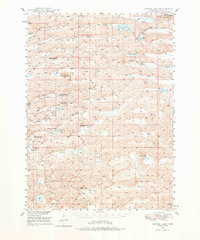
 1948 Spring Valley1978 Print · USGSGrant County ranching country is captured here in the late 1940s, showing the remote settlement patterns of the Sandhills. Researchers can locate early educational landmarks like Rose Hill Sch and School No 8, alongside numerous namesake water bodies such as Winnie Lake.
 - 1949 Map of Ashby
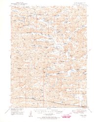 1949 Ashby1949 Print · USGSPost-war Nebraska ranching life and the Sandhills topography come alive in this survey of the Cherry and Grant county lines. Trace old homesteads and landmarks like the Diamond Bar Ranch, the Consolidated Sch, and Wolfenberger Lakes along the Chicago Burlington and Quincy line.3 unique versions available
End of results
Showing maps 1-4 of 4
Frequently asked questions
- What are the different types of historical maps available for Hyannis?
- What is the oldest map of Hyannis?
- Where can I purchase historical maps of Hyannis for my home or office?
- Where can I download high-res historical maps of Hyannis?
- Are there historical topographic maps available for Hyannis?
- Is there historical aerial imagery available for Hyannis?
- Where are historical maps of Hyannis sourced from?