1960s Maps of Hitchcock County, Nebraska
Explore 8 historic maps of Hitchcock County from the 1960s. These maps offer a rare glimpse into what life looked like during the 1960s — showing old roads, neighborhoods, homes, and landmarks that have changed or disappeared over time.
Whether you're researching your family's past, planning a metal detecting trip, or studying how Hitchcock County's landscape evolved across the 1960s, these high-resolution maps are a powerful tool for exploring the history of this region.
- Focus on a specific era: All maps on this page are from the 1960s, giving you a focused view of this time period.
- See what’s changed: Compare century-old streets, trails, and buildings to today's modern landscape using overlays and satellite layers.
- Research with precision: Use these maps for genealogy, historical research, land use analysis, or educational projects.
- View, download, or print: Maps are fully viewable online in high resolution, and can be downloaded or printed for your own records.
Start exploring Hitchcock County's history through authentic maps from the 1960s. This is your window into the past.
Hitchcock County, NE maps
(8)- 1962 Map of Trenton, 1964 Print
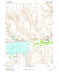 1962 Trenton1964 Print · USGSHitchcock County landscapes were undergoing significant change in the early sixties as the Missouri River Basin project shaped the local waters. Genealogists and local historians can locate St James Cemetery, trace the Chicago Burlington and Quincy rail line, and explore the rugged breaks of Massacre Canyon.
 - 1962 Map of Trenton SW, 1964 Print
 1962 Trenton SW1964 Print · USGSThe Nebraska-Kansas borderlands come into focus in the early sixties as new water management reshapes the plains. Genealogists can locate McCabe Cem and trace the rural townships of Freedom, Stratton, and Burntwood along the creek.
 - 1962 Map of Culbertson NW, 1964 Print
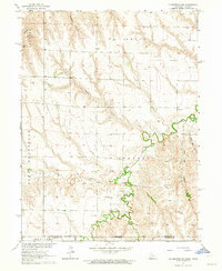
 1962 Culbertson NW1964 Print · USGSHitchcock County in the early sixties reveals a landscape of deep canyons and intricate river valleys during the height of the Missouri River Basin development. Genealogists and local historians can trace the North Riverside Sch, the Trenton Cem, and the path of the Chicago Burlington and Quincy railroad.
 - 1962 Map of Max SE, 1964 Print
 1962 Max SE1964 Print · USGSThe Nebraska-Kansas borderlands in the early sixties reveal a landscape of deep creek valleys and river-bottom rail lines. Genealogists and historians can trace local landmarks like West Union Cem and the Chicago Burlington and Quincy tracks.
 - 1962 Map of Culbertson SW, 1964 Print
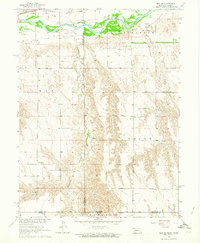
 1962 Culbertson SW1964 Print · USGSThe Nebraska-Kansas borderlands in the early sixties reveal a landscape of deep canyons and rural schoolhouses. Researchers can trace the roots of the Cornell community at Cornell Ch and Cornell Cem, or locate landmarks like Hoagland and Fairplains Sch.
 - 1962 Map of Trenton SE, 1964 Print
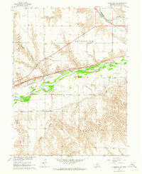
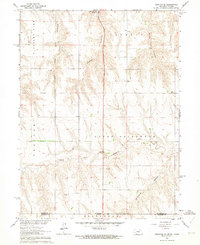 1962 Trenton SE1964 Print · USGSThe Nebraska-Kansas borderlands in the early sixties reveal a landscape of deep canyons and rural schoolhouses north of Rawlins County. Researchers can trace the Nebraska Kansas Base Line and locate historic community sites like School No 42 and Ford Sch.2 unique versions available
 - 1962 Map of Stratton, 1964 Print
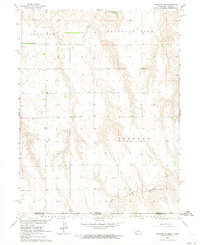
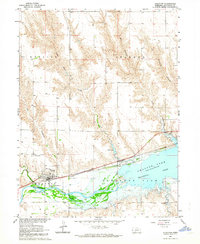 1962 Stratton1964 Print · USGSStratton flourished as a rail and river town in the early sixties, situated just west of the newly formed Swanson Lake. Researchers can trace the legacy of local families at Stratton Cem or explore the canyonlands of Hay Canyon and Macklin Canyon.
 - 1962 Map of Max NE, 1964 Print
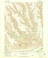 1962 Max NE1964 Print · USGSHitchcock and Dundy counties are shown in the early sixties as a landscape of deeply eroded canyons and river bottomland. Genealogists and researchers can locate the Ash Grove Cem, trace the Chicago Burlington and Quincy railroad, and find the settlement of Lingo.
End of results
Showing maps 1-8 of 8
Top cities of Hitchcock County
Frequently asked questions
- What are the different types of historical maps available for Hitchcock County?
- What is the oldest map of Hitchcock County?
- Where can I purchase historical maps of Hitchcock County for my home or office?
- Where can I download high-res historical maps of Hitchcock County?
- Are there historical topographic maps available for Hitchcock County?
- Is there historical aerial imagery available for Hitchcock County?
- Where are historical maps of Hitchcock County sourced from?