1960s Maps of Holt County, Nebraska
Explore 14 historic maps of Holt County from the 1960s. These maps offer a rare glimpse into what life looked like during the 1960s — showing old roads, neighborhoods, homes, and landmarks that have changed or disappeared over time.
Whether you're researching your family's past, planning a metal detecting trip, or studying how Holt County's landscape evolved across the 1960s, these high-resolution maps are a powerful tool for exploring the history of this region.
- Focus on a specific era: All maps on this page are from the 1960s, giving you a focused view of this time period.
- See what’s changed: Compare century-old streets, trails, and buildings to today's modern landscape using overlays and satellite layers.
- Research with precision: Use these maps for genealogy, historical research, land use analysis, or educational projects.
- View, download, or print: Maps are fully viewable online in high resolution, and can be downloaded or printed for your own records.
Start exploring Holt County's history through authentic maps from the 1960s. This is your window into the past.
Holt County, NE maps
(14)- 1963 Map of Deloit, 1964 Print
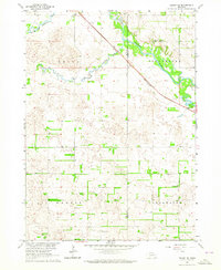
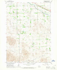
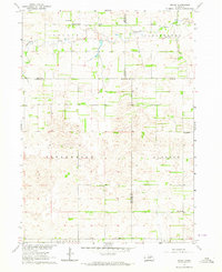 1963 Deloit1964 Print · USGSAgricultural life in the early sixties centers on the rural township of Deloit. Researchers can trace the network of country schoolhouses like School No 60, find family landmarks at Knievels Corner, or locate the Wolf Cem.2 unique versions available
 - 1963 Map of Ewing SW, 1964 Print
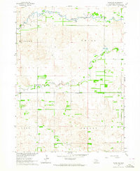
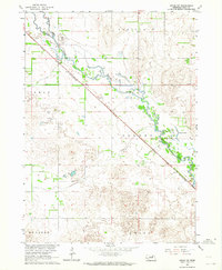 1963 Ewing SW1964 Print · USGSHolt County ranching country and the Elkhorn River valley are captured here in the early sixties. History buffs can trace the diagonal path of the Chicago and North Western railroad through Stafford and past the remote Chain Lakes.2 unique versions available
 - 1963 Map of Deloit SW, 1964 Print
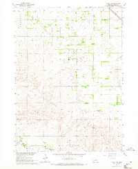
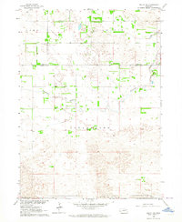 1963 Deloit SW1964 Print · USGSWheeler and Holt counties appear here in the early sixties as a landscape of remote ranching and rural township life. Genealogists and local historians can locate St Anthonys Cem, the remote School No 146, and the winding course of Clearwater Creek.2 unique versions available
 - 1963 Map of Venus, 1964 Print
 1963 Venus1964 Print · USGSNortheastern Nebraska ranchland is captured here in the early sixties at the meeting point of Holt, Knox, and Antelope counties. Genealogists can trace rural family life through features like Venus, Lambert Cem, and country schools like Cream Ridge Sch.2 unique versions available
 - 1963 Map of Ewing, 1964 Print
 1963 Ewing1964 Print · USGSEwing and the surrounding Nebraska townships thrive along the river forks during the early sixties. Genealogists and local historians can trace the paths of the Chicago and North Western railroad or locate landmarks like St Peter Cem and Emporia Sch.2 unique versions available
 - 1963 Map of Deloit NE, 1964 Print
 1963 Deloit NE1964 Print · USGSThe rural prairie of Holt and Antelope counties is captured here in the early sixties, showing the rail-and-river landscape of north-central Nebraska. Genealogists and local historians can locate early landmarks like St Patricks Cem, Riverside Ch, and the Rosedale Sch.2 unique versions available
 - 1963 Map of Deloit NW, 1964 Print
 1963 Deloit NW1964 Print · USGSHolt County, Nebraska, is seen in the early sixties as a region of winding river forks and scattered prairie townships. You can trace local family landmarks and rural infrastructure through Vandersnick Cem, Hubel Airfield, and the Cache Creek Valley Sch.2 unique versions available
 - 1964 Map of O'Neill SE, 1965 Print
 1964 O'Neill SE1965 Print · USGSHolt County's rural landscape is captured here in the mid-1960s as the Chicago and North Western rail line served the prairie. You can trace the S Fork Elkhorn R or locate local landmarks like Stafford, Willow Lake Sch, and Inman Cem.2 unique versions available
 - 1964 Map of Emmet NW, 1965 Print
 1964 Emmet NW1965 Print · USGSHolt County's rural landscape is captured here in the mid-1960s, showing the intersection of the Elkhorn River and the Chicago and North Western line. Researchers can pinpoint early educational sites like School No 35 and localized landmarks such as the Flowing Well.2 unique versions available
 - 1964 Map of Emmet SE, 1965 Print
 1964 Emmet SE1965 Print · USGSHolt County's prairie and ranching landscape is meticulously detailed here during the mid-1960s. Researchers can trace land use patterns across Emmet and Shamrock townships, locating features like Schaffer, a Claypit, and the Flowing Well.2 unique versions available
 - 1964 Map of Emmet SW, 1965 Print
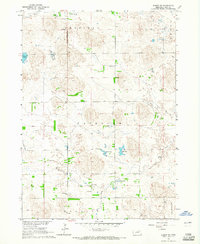 1964 Emmet SW1965 Print · USGSHolt County's sandhills are captured here in the mid-sixties, showing a landscape of remote ranching townships and vital groundwater sources. Genealogists and local historians can locate School No 231 and several Flowing Wells near Lizard Lake and Gold Lake.2 unique versions available
 - 1964 Map of O'Neill SW, 1965 Print
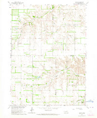
 1964 O'Neill SW1965 Print · USGSHolt County ranchlands are captured here in the mid-1960s, showing the early boundaries of local townships. Researchers can trace land divisions across Shamrock and Gratton or follow the path of the South Fork Elkhorn River.2 unique versions available
 - 1964 Map of Emmet, 1965 Print
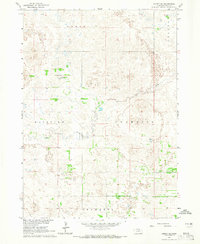
 1964 Emmet1965 Print · USGSHolt County, Nebraska, comes into focus in the mid-1960s as the rail-and-river economy centers on the village of Emmet. Researchers can trace old rural property boundaries, schoolhouses like School No 141, and the tracks of the Chicago and North Western railroad.2 unique versions available
 - 1969 Map of O'Neill
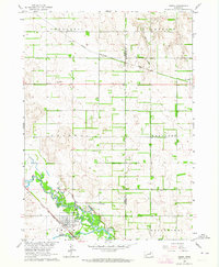
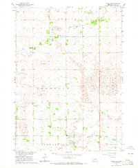
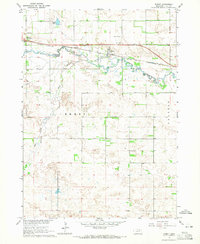
 1969 O'Neill1969 Print · USGSCentral Nebraska in the mid-fifties is defined here by the expansive Sand Hills and the winding Niobrara River. Trace the Chicago and North Western rail line through cattle towns like O'Neill and Ainsworth.
End of results
Showing maps 1-14 of 14
Top cities of Holt County
- O'Neill historical maps
- Atkinson historical maps
- Stuart historical maps
- Ewing historical maps
- Chambers historical maps
- Page historical maps
See more
Frequently asked questions
- What are the different types of historical maps available for Holt County?
- What is the oldest map of Holt County?
- Where can I purchase historical maps of Holt County for my home or office?
- Where can I download high-res historical maps of Holt County?
- Are there historical topographic maps available for Holt County?
- Is there historical aerial imagery available for Holt County?
- Where are historical maps of Holt County sourced from?