1980s Maps of Keya Paha County, Nebraska
Explore 7 historic maps of Keya Paha County from the 1980s. These maps offer a rare glimpse into what life looked like during the 1980s — showing old roads, neighborhoods, homes, and landmarks that have changed or disappeared over time.
Whether you're researching your family's past, planning a metal detecting trip, or studying how Keya Paha County's landscape evolved across the 1980s, these high-resolution maps are a powerful tool for exploring the history of this region.
- Focus on a specific era: All maps on this page are from the 1980s, giving you a focused view of this time period.
- See what’s changed: Compare century-old streets, trails, and buildings to today's modern landscape using overlays and satellite layers.
- Research with precision: Use these maps for genealogy, historical research, land use analysis, or educational projects.
- View, download, or print: Maps are fully viewable online in high resolution, and can be downloaded or printed for your own records.
Start exploring Keya Paha County's history through authentic maps from the 1980s. This is your window into the past.
Keya Paha County, NE maps
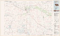
(7)- 1983 Map of Norden, 1984 Print
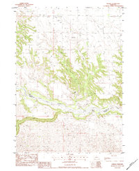 1983 Norden1984 Print · USGSNorden and the Nebraska Sandhills transition are captured here in the early eighties as a dedicated ranching landscape. Researchers can locate the Norden Cem, the County Fairground, and established family operations like the Egelhoff Ranch near the Niobrara River.
 - 1983 Map of Muleshoe Creek, 1984 Print
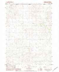
 1983 Muleshoe Creek1984 Print · USGSThe Nebraska borderlands in the early eighties were defined by the winding Niobrara River and its rugged creek systems. Researchers can trace remote ranching sites like the Owens Ranch and historic river access points such as Rocky Ford.2 unique versions available
 - 1983 Map of Hayford Lake, 1984 Print
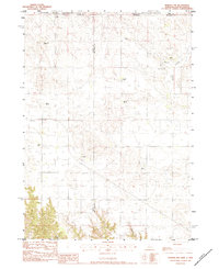
 1983 Hayford Lake1984 Print · USGSThe ranching landscape of the Nebraska-South Dakota border comes into focus in the early eighties. Genealogists and local historians can trace family-named landmarks such as Mf Ranch, Worth Ranch, and Rose Valley Ranch situated near the waters of Hayford Lake.
 - 1983 Map of Norden NW, 1984 Print
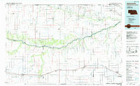
 1983 Norden NW1984 Print · USGSRanching life on the Nebraska-South Dakota border is detailed in this early 1980s survey of the High Plains. Genealogists and local historians can locate family landmarks like Lawrence Ranch, Sparks Cem, and the Shadley Creek Sch.
 - 1985 Map of Ainsworth
 1985 Ainsworth1985 Print · USGSThe Nebraska-South Dakota borderlands come into focus in the mid-1980s, documenting a landscape of river breaks and remote ranching hubs. Genealogists can trace the rural layout of Ainsworth, Bassett, and Springview or follow the Chicago and North Western rail line.2 unique versions available
 - 1985 Map of Valentine
 1985 Valentine1985 Print · USGSThe Nebraska Sandhills in the mid-1980s reveal a landscape of vast wildlife refuges and rail-linked prairie towns. Researchers can trace the Chicago and North Western corridor through Kilgore and Valentine or locate remote landmarks like Snake River Falls.2 unique versions available
 - 1989 Map of O'Neill
 1989 O'Neill1989 Print · USGSThe Nebraska-South Dakota borderlands are captured here in the late eighties, documenting the ranching and rail infrastructure of the High Plains. Genealogists and collectors can trace historic prairie towns like Monowi, Pishelville, and Santee along the Niobrara River.
End of results
Showing maps 1-7 of 7
Top cities of Keya Paha County
Frequently asked questions
- What are the different types of historical maps available for Keya Paha County?
- What is the oldest map of Keya Paha County?
- Where can I purchase historical maps of Keya Paha County for my home or office?
- Where can I download high-res historical maps of Keya Paha County?
- Are there historical topographic maps available for Keya Paha County?
- Is there historical aerial imagery available for Keya Paha County?
- Where are historical maps of Keya Paha County sourced from?