1940s Maps of Keya Paha County, Nebraska
Explore 4 historic maps of Keya Paha County from the 1940s. These maps offer a rare glimpse into what life looked like during the 1940s — showing old roads, neighborhoods, homes, and landmarks that have changed or disappeared over time.
Whether you're researching your family's past, planning a metal detecting trip, or studying how Keya Paha County's landscape evolved across the 1940s, these high-resolution maps are a powerful tool for exploring the history of this region.
- Focus on a specific era: All maps on this page are from the 1940s, giving you a focused view of this time period.
- See what’s changed: Compare century-old streets, trails, and buildings to today's modern landscape using overlays and satellite layers.
- Research with precision: Use these maps for genealogy, historical research, land use analysis, or educational projects.
- View, download, or print: Maps are fully viewable online in high resolution, and can be downloaded or printed for your own records.
Start exploring Keya Paha County's history through authentic maps from the 1940s. This is your window into the past.
Keya Paha County, NE maps
(4)- 1949 Map of Dutch Creek, 1976 Print
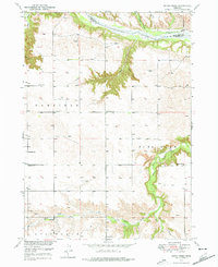 1949 Dutch Creek1976 Print · USGSBrown County's rugged Niobrara riverfront comes to life in this mid-century survey of the Garfield and Pine Glen precincts. Genealogists and historians can locate family landmarks like Lessig Cem and numerous rural schoolhouses including Jones Sch and Highland Sch.
 - 1949 Map of Jamison SW, 1976 Print
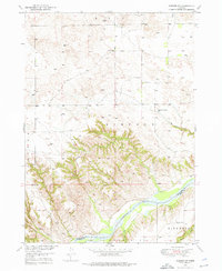 1949 Jamison SW1976 Print · USGSThe Niobrara River breaks in north-central Nebraska are captured here in the late 1940s as rural life centered on the local schoolhouse. Genealogists and local historians can trace ranching roots through landmarks like Bothwell Sch, Holton Sch, and Big Anne Spring.
 - 1949 Map of Riverview, 1977 Print
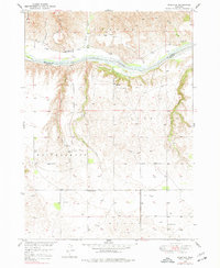 1949 Riverview1977 Print · USGSThe Niobrara River valley in the late 1940s was a remote ranching landscape of deep draws and isolated schools. Genealogists and historians can locate old rural education sites like Lamb Sch and School No 61 or the tiny settlement of Riverview.
 - 1949 Map of Carns, 1979 Print
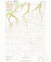 1949 Carns1979 Print · USGSThe Niobrara River valley in the late 1940s remained a landscape of dispersed ranching and localized school districts. Researchers can trace the rural community through its many one-room schoolhouses like Turkey Foot Sch, the settlement at Carns, and the quiet grounds of Willowdale Cem.
End of results
Showing maps 1-4 of 4
Top cities of Keya Paha County
Frequently asked questions
- What are the different types of historical maps available for Keya Paha County?
- What is the oldest map of Keya Paha County?
- Where can I purchase historical maps of Keya Paha County for my home or office?
- Where can I download high-res historical maps of Keya Paha County?
- Are there historical topographic maps available for Keya Paha County?
- Is there historical aerial imagery available for Keya Paha County?
- Where are historical maps of Keya Paha County sourced from?