1900s (20th Century) Maps of Battle Creek, Nebraska
Explore 10 historic maps of Battle Creek from the 1900s (20th Century). These maps offer a rare glimpse into what life looked like during the 1900s — showing old roads, neighborhoods, homes, and landmarks that have changed or disappeared over time.
Whether you're researching your family's past, planning a metal detecting trip, or studying how Battle Creek's landscape evolved across the 1900s, these high-resolution maps are a powerful tool for exploring the history of this region.
- Focus on a specific era: All maps on this page are from the 1900s, giving you a focused view of this time period.
- See what’s changed: Compare century-old streets, trails, and buildings to today's modern landscape using overlays and satellite layers.
- Research with precision: Use these maps for genealogy, historical research, land use analysis, or educational projects.
- View, download, or print: Maps are fully viewable online in high resolution, and can be downloaded or printed for your own records.
Start exploring Battle Creek's history through authentic maps from the 1900s. This is your window into the past.
Battle Creek, NE maps
(10)- 1955 Map of Sioux City, 1959 Print
 1955 Sioux City1959 Print · USGSThe Missouri River valley in the mid-fifties is captured here during a time of major engineering and social transition. Genealogists and historians can trace the foundations of Gavins Point Dam, tribal boundaries on the Santee Sioux Indian Reservation, and local landmarks like the Norfolk State Hospital.4 unique versions available
 - 1955 Map of Fremont, 1966 Print
 1955 Fremont1966 Print · USGSEastern Nebraska and the Missouri River border are captured during the mid-fifties, just as the interstate system began to emerge. Researchers can trace the development of Omaha, locate the sprawling Offutt Air Force Base, or study the river-bound ecology of the De Soto National Wildlife Refuge.3 unique versions available
 - 1957 Map of Fremont
 1957 Fremont1957 Print · USGSEastern Nebraska and western Iowa thrive along the Platte and Missouri rivers during the mid-fifties. Genealogists can locate small rural schools like Fairview School and tracing the paths of the Union Pacific through towns like Albion and Humphrey.
 - 1958 Map of Sioux City
 1958 Sioux City1958 Print · USGSThe Missouri River valley in the late fifties was a bustling intersection of tribal lands, rail corridors, and river towns. Genealogists can trace family roots through specific rural sites like Daisy Valley School, St Johns Church and School, and Yankton State Hospital.
 - 1958 Map of Fremont
 1958 Fremont1958 Print · USGSEastern Nebraska in the late fifties is captured here as a thriving corridor of river-valley commerce and rail transport. Researchers can trace the development of Omaha and Fremont or locate local landmarks like Midland College and Offutt Air Force Base.
 - 1959 Map of Sioux City
 1959 Sioux City1959 Print · USGSThe tri-state region surrounding the Missouri River is captured here in the late fifties, showing the convergence of Nebraska, South Dakota, and Iowa. Researchers can trace rural lineages through numerous country schoolhouses like Cemetery School and the many numbered Washington School districts.
 - 1963 Map of Battle Creek, 1964 Print
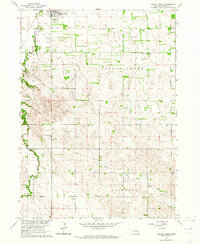 1963 Battle Creek1964 Print · USGSBattle Creek and its surrounding Madison County townships are captured in the early sixties as a thriving network of rural communities. Family researchers can trace exact locations for Allbery Cem, Fairview Ch, and several local landmarks like St Peters Sch.2 unique versions available
 - 1963 Map of Pierce SE, 1964 Print
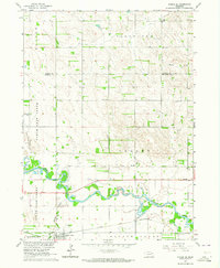 1963 Pierce SE1964 Print · USGSMadison and Pierce counties come alive in the early sixties, showing the agricultural heartland centered on the Battle Creek community. Genealogists can trace family roots through numerous rural schoolhouses like Dederman Sch and the grounds of St Patricks Cem.2 unique versions available
 - 1985 Map of Stanton
 1985 Stanton1985 Print · USGSNortheast Nebraska in the mid-eighties shows a landscape of river-valley agriculture and evolving rail networks. Genealogists can trace family footprints through Stanton and Madison, or locate historical markers like the Old Indian Treaty Boundary and Saint Bernard.2 unique versions available
 - 1985 Map of Norfolk, 1986 Print
 1985 Norfolk1986 Print · USGSNortheast Nebraska in the mid-eighties shows a landscape shaped by the Elkhorn River and established rail corridors. Trace the growth of towns like Norfolk and Wayne, locating institutional landmarks such as Wayne State College and Norfolk Regional Center.2 unique versions available
End of results
Showing maps 1-10 of 10
Top cities near Battle Creek
- Norfolk historical maps
- Madison historical maps
- Pierce historical maps
- Tilden historical maps
- Hadar historical maps
- Meadow Grove historical maps
See more
Frequently asked questions
- What are the different types of historical maps available for Battle Creek?
- What is the oldest map of Battle Creek?
- Where can I purchase historical maps of Battle Creek for my home or office?
- Where can I download high-res historical maps of Battle Creek?
- Are there historical topographic maps available for Battle Creek?
- Is there historical aerial imagery available for Battle Creek?
- Where are historical maps of Battle Creek sourced from?