1960s Maps of Battle Creek, Nebraska
Explore 2 historic maps of Battle Creek from the 1960s. These maps offer a rare glimpse into what life looked like during the 1960s — showing old roads, neighborhoods, homes, and landmarks that have changed or disappeared over time.
Whether you're researching your family's past, planning a metal detecting trip, or studying how Battle Creek's landscape evolved across the 1960s, these high-resolution maps are a powerful tool for exploring the history of this region.
- Focus on a specific era: All maps on this page are from the 1960s, giving you a focused view of this time period.
- See what’s changed: Compare century-old streets, trails, and buildings to today's modern landscape using overlays and satellite layers.
- Research with precision: Use these maps for genealogy, historical research, land use analysis, or educational projects.
- View, download, or print: Maps are fully viewable online in high resolution, and can be downloaded or printed for your own records.
Start exploring Battle Creek's history through authentic maps from the 1960s. This is your window into the past.
Battle Creek, NE maps
(2)- 1963 Map of Battle Creek, 1964 Print
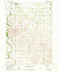 1963 Battle Creek1964 Print · USGSBattle Creek and its surrounding Madison County townships are captured in the early sixties as a thriving network of rural communities. Family researchers can trace exact locations for Allbery Cem, Fairview Ch, and several local landmarks like St Peters Sch.2 unique versions available
 - 1963 Map of Pierce SE, 1964 Print
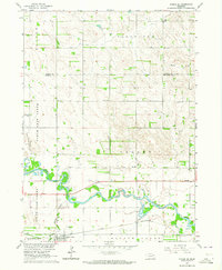 1963 Pierce SE1964 Print · USGSMadison and Pierce counties come alive in the early sixties, showing the agricultural heartland centered on the Battle Creek community. Genealogists can trace family roots through numerous rural schoolhouses like Dederman Sch and the grounds of St Patricks Cem.2 unique versions available
End of results
Showing maps 1-2 of 2
Top cities near Battle Creek
- Norfolk historical maps
- Madison historical maps
- Pierce historical maps
- Tilden historical maps
- Hadar historical maps
- Meadow Grove historical maps
See more
Frequently asked questions
- What are the different types of historical maps available for Battle Creek?
- What is the oldest map of Battle Creek?
- Where can I purchase historical maps of Battle Creek for my home or office?
- Where can I download high-res historical maps of Battle Creek?
- Are there historical topographic maps available for Battle Creek?
- Is there historical aerial imagery available for Battle Creek?
- Where are historical maps of Battle Creek sourced from?