1940s Maps of Otoe County, Nebraska
Explore 2 historic maps of Otoe County from the 1940s. These maps offer a rare glimpse into what life looked like during the 1940s — showing old roads, neighborhoods, homes, and landmarks that have changed or disappeared over time.
Whether you're researching your family's past, planning a metal detecting trip, or studying how Otoe County's landscape evolved across the 1940s, these high-resolution maps are a powerful tool for exploring the history of this region.
- Focus on a specific era: All maps on this page are from the 1940s, giving you a focused view of this time period.
- See what’s changed: Compare century-old streets, trails, and buildings to today's modern landscape using overlays and satellite layers.
- Research with precision: Use these maps for genealogy, historical research, land use analysis, or educational projects.
- View, download, or print: Maps are fully viewable online in high resolution, and can be downloaded or printed for your own records.
Start exploring Otoe County's history through authentic maps from the 1940s. This is your window into the past.
Otoe County, NE maps
(2)- 1940 Map of Nehawka
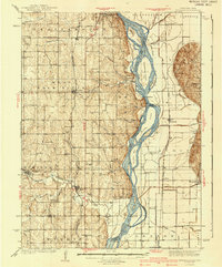 1940 Nehawka1940 Print · USGSThe Missouri River valley comes to life in this pre-war survey of Cass County and the Iowa border. Genealogists can locate family names at Youngs Cem or trace dozens of rural school sites like Cottonwood Sch and Eightmile Grove Sch.3 unique versions available
 - 1941 Map of Hamburg
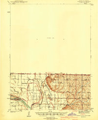 1941 Hamburg1941 Print · USGSThe Missouri-Iowa borderlands come alive in this pre-war survey of the river's winding oxbows and rural townships. Genealogists can trace family roots through a dense network of country schools and churches, from Mayflower Sch to the Stoner Cem.2 unique versions available
End of results
Showing maps 1-2 of 2
Top cities of Otoe County
- Nebraska City historical maps
- Syracuse historical maps
- Palmyra historical maps
- Unadilla historical maps
- Talmage historical maps
- Dunbar historical maps
See more
Frequently asked questions
- What are the different types of historical maps available for Otoe County?
- What is the oldest map of Otoe County?
- Where can I purchase historical maps of Otoe County for my home or office?
- Where can I download high-res historical maps of Otoe County?
- Are there historical topographic maps available for Otoe County?
- Is there historical aerial imagery available for Otoe County?
- Where are historical maps of Otoe County sourced from?