1900-1909 Maps of Otoe County, Nebraska
Explore 2 historic maps of Otoe County from 1900-1909. These maps offer a rare glimpse into what life looked like during the 1900s — showing old roads, neighborhoods, homes, and landmarks that have changed or disappeared over time.
Whether you're researching your family's past, planning a metal detecting trip, or studying how Otoe County's landscape evolved across the 1900s, these high-resolution maps are a powerful tool for exploring the history of this region.
- Focus on a specific era: All maps on this page are from the 1900s, giving you a focused view of this time period.
- See what’s changed: Compare century-old streets, trails, and buildings to today's modern landscape using overlays and satellite layers.
- Research with precision: Use these maps for genealogy, historical research, land use analysis, or educational projects.
- View, download, or print: Maps are fully viewable online in high resolution, and can be downloaded or printed for your own records.
Start exploring Otoe County's history through authentic maps from the 1900s. This is your window into the past.
Otoe County, NE maps
(2)- 1903 Map of Weeping Water
 1903 Weeping Water1903 Print · USGSSoutheast Nebraska at the start of the twentieth century was a thriving patchwork of rail-dependent prairie towns and river valleys. Genealogists and local historians can trace early property boundaries and township seats like Weeping Water, Syracuse, and the riverside town of Louisville.2 unique versions available
 - 1907 Map of Nebraska City
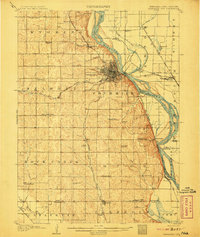 1907 Nebraska City1907 Print · USGSNebraska City and its surrounding Missouri River bluffs are captured here in the first decade of the 1900s during a period of significant rail expansion. Genealogists can locate numerous rural schoolhouses and small settlements like Minersville, Wyoming, and the historic St Lukes Church.3 unique versions available
End of results
Showing maps 1-2 of 2
Top cities of Otoe County
- Nebraska City historical maps
- Syracuse historical maps
- Palmyra historical maps
- Unadilla historical maps
- Talmage historical maps
- Dunbar historical maps
See more
Frequently asked questions
- What are the different types of historical maps available for Otoe County?
- What is the oldest map of Otoe County?
- Where can I purchase historical maps of Otoe County for my home or office?
- Where can I download high-res historical maps of Otoe County?
- Are there historical topographic maps available for Otoe County?
- Is there historical aerial imagery available for Otoe County?
- Where are historical maps of Otoe County sourced from?