1890s Maps of Phelps County, Nebraska
Explore 7 historic maps of Phelps County from the 1890s. These maps offer a rare glimpse into what life looked like during the 1890s — showing old roads, neighborhoods, homes, and landmarks that have changed or disappeared over time.
Whether you're researching your family's past, planning a metal detecting trip, or studying how Phelps County's landscape evolved across the 1890s, these high-resolution maps are a powerful tool for exploring the history of this region.
- Focus on a specific era: All maps on this page are from the 1890s, giving you a focused view of this time period.
- See what’s changed: Compare century-old streets, trails, and buildings to today's modern landscape using overlays and satellite layers.
- Research with precision: Use these maps for genealogy, historical research, land use analysis, or educational projects.
- View, download, or print: Maps are fully viewable online in high resolution, and can be downloaded or printed for your own records.
Start exploring Phelps County's history through authentic maps from the 1890s. This is your window into the past.
Phelps County, NE maps
(7)- 1894 Map of Kearney
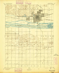 1894 Kearney1894 Print · USGSKearney and the Platte River valley are captured in the late nineteenth century as a vital railroad junction and irrigation center. Genealogists and local historians can trace early settlements like Odessa and West Kearney, or study the complex river channels around Long Island and Evarts Island.2 unique versions available
 - 1896 Map of Lexington
 1896 Lexington1896 Print · USGSDawson and Gosper Counties in the mid-1890s are defined by the convergence of the Platte River and competing railroad lines. Genealogists can trace family settlements along the Union Pacific R. R. and the Burlington and Missouri River R. R., locating early sites like Elwood and Coyote.
 - 1896 Map of Holdrege
 1896 Holdrege1896 Print · USGSSouth-central Nebraska was a burgeoning network of rail towns and river settlements in the late nineteenth century. Genealogists can trace family roots along the Republican River valley in Alma, Bloomington, and Naponee, or explore the early growth of Holdrege as a vital railroad junction.5 unique versions available
 - 1896 Map of Kearney
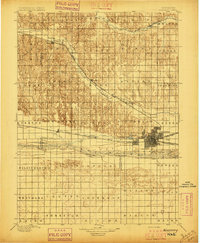 1896 Kearney1896 Print · USGSBuffalo County and the Platte River valley are captured in the late 1890s as the railroad network cemented the region's growth. Genealogists can locate family lands across townships like Williamsburg or trace the early paths of the Union Pacific R. R. and Kearney Canal.7 unique versions available
 - 1896 Map of Arapahoe
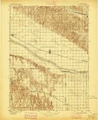
 1896 Arapahoe1896 Print · USGSThe Republican River valley thrived in the 1890s as a vital railroad corridor through south-central Nebraska and northern Kansas. Genealogists and local historians can trace the early rail stops and rural precincts like Arapahoe, Oxford, and the remote Rock Falls district.3 unique versions available
 - 1898 Map of Arapahoe, 1920 Print
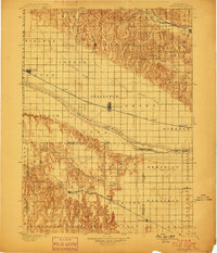
 1898 Arapahoe1920 Print · USGSSouthwestern Nebraska was rapidly developing at the turn of the century as railroads mirrored the river valleys. Genealogists can trace family roots in towns like Arapahoe, Beaver City, and Oxford or locate landmarks like Rock Falls.2 unique versions available
 - 1899 Map of Lexington
 1899 Lexington1899 Print · USGSDawson and Gosper counties are captured during a period of rapid prairie development following the arrival of the transcontinental rails. Genealogists can trace the early grids of rail towns like Lexington and Bertrand or the spans of the Lexington Bridge.7 unique versions available
End of results
Showing maps 1-7 of 7
Top cities of Phelps County
- Holdrege historical maps
- Bertrand historical maps
- Loomis historical maps
- Westmark historical maps
- Funk historical maps
- Atlanta historical maps
Frequently asked questions
- What are the different types of historical maps available for Phelps County?
- What is the oldest map of Phelps County?
- Where can I purchase historical maps of Phelps County for my home or office?
- Where can I download high-res historical maps of Phelps County?
- Are there historical topographic maps available for Phelps County?
- Is there historical aerial imagery available for Phelps County?
- Where are historical maps of Phelps County sourced from?