1960s Maps of Phelps County, Nebraska
Explore 5 historic maps of Phelps County from the 1960s. These maps offer a rare glimpse into what life looked like during the 1960s — showing old roads, neighborhoods, homes, and landmarks that have changed or disappeared over time.
Whether you're researching your family's past, planning a metal detecting trip, or studying how Phelps County's landscape evolved across the 1960s, these high-resolution maps are a powerful tool for exploring the history of this region.
- Focus on a specific era: All maps on this page are from the 1960s, giving you a focused view of this time period.
- See what’s changed: Compare century-old streets, trails, and buildings to today's modern landscape using overlays and satellite layers.
- Research with precision: Use these maps for genealogy, historical research, land use analysis, or educational projects.
- View, download, or print: Maps are fully viewable online in high resolution, and can be downloaded or printed for your own records.
Start exploring Phelps County's history through authentic maps from the 1960s. This is your window into the past.
Phelps County, NE maps
(5)- 1961 Map of Elm Creek West, 1963 Print
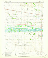 1961 Elm Creek West1963 Print · USGSCentral Nebraska's river valley and rail corridor are captured here in the early sixties, as the irrigation-fed landscape prepared for modern highway expansion. Genealogists can locate rural landmarks like Williamsburg Ch, East Twelfth Sch, and the small siding at Trued.
 - 1962 Map of Elm Creek East, 1964 Print
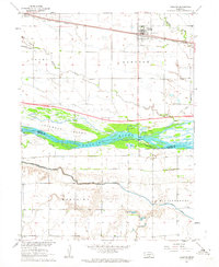
 1962 Elm Creek East1964 Print · USGSBuffalo County, Nebraska, is seen here during the transition to the interstate era in the early 1960s. Genealogists and local historians can trace the foundations of Elm Creek and Odessa or locate vanished landmarks like the Landing Field and early Gravel Pits.2 unique versions available
 - 1962 Map of Overton, 1964 Print
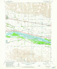
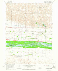
 1962 Overton1964 Print · USGSOverton and the Platte River valley are captured in the early sixties as a major new interstate highway was taking shape. Genealogists and local historians can trace rural roots at Overton Cem, Adullam Ch, and the site of West Twelfth Sch.2 unique versions available
 - 1962 Map of Bertrand NW, 1964 Print
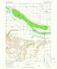 1962 Bertrand NW1964 Print · USGSThe Platte River valley in the early sixties reveals a landscape in transition as the interstate highway began to carve through Nebraska's agricultural core. Genealogists can locate family-named landmarks like Robb Cem or trace early education at School No 3 and Spring Creek Sch.2 unique versions available
 - 1962 Map of Alfalfa Center, 1964 Print
 1962 Alfalfa Center1964 Print · USGSBuffalo County is shown during the early 1960s as a landscape in transition, where new highway construction began to parallel the historic rail lines. Researchers can trace rural school districts like School No 114 and family landmarks near Dove Hill Cem and Alfalfa Center.2 unique versions available
End of results
Showing maps 1-5 of 5
Top cities of Phelps County
- Holdrege historical maps
- Bertrand historical maps
- Loomis historical maps
- Westmark historical maps
- Funk historical maps
- Atlanta historical maps
Frequently asked questions
- What are the different types of historical maps available for Phelps County?
- What is the oldest map of Phelps County?
- Where can I purchase historical maps of Phelps County for my home or office?
- Where can I download high-res historical maps of Phelps County?
- Are there historical topographic maps available for Phelps County?
- Is there historical aerial imagery available for Phelps County?
- Where are historical maps of Phelps County sourced from?