1800s (19th Century) Maps of Scotts Bluff County, Nebraska
Explore 5 historic maps of Scotts Bluff County from the 1800s (19th Century). These maps offer a rare glimpse into what life looked like during the 1800s — showing old roads, neighborhoods, homes, and landmarks that have changed or disappeared over time.
Whether you're researching your family's past, planning a metal detecting trip, or studying how Scotts Bluff County's landscape evolved across the 1800s, these high-resolution maps are a powerful tool for exploring the history of this region.
- Focus on a specific era: All maps on this page are from the 1800s, giving you a focused view of this time period.
- See what’s changed: Compare century-old streets, trails, and buildings to today's modern landscape using overlays and satellite layers.
- Research with precision: Use these maps for genealogy, historical research, land use analysis, or educational projects.
- View, download, or print: Maps are fully viewable online in high resolution, and can be downloaded or printed for your own records.
Start exploring Scotts Bluff County's history through authentic maps from the 1800s. This is your window into the past.
Scotts Bluff County, NE maps
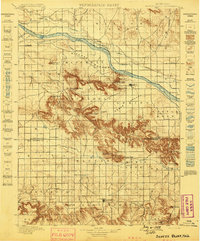
(5)- 1896 Map of Patrick
 1896 Patrick1896 Print · USGSEastern Wyoming ranching life is frozen in time during the mid-1890s, when family-run operations dominated the high plains. Genealogists can trace early homesteads like Nolan's Ranch, Sturdivant's Ranch, and the early settlement at Torrington.7 unique versions available
 - 1898 Map of Scotts Bluff
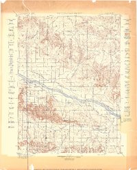
 1898 Scotts Bluff1898 Print · USGSWestern Nebraska at the end of the century was a landscape of emerging irrigation and prominent landmarks. You can trace the development of early irrigation canals along the North Platte River and locate historic sites like Gering, Roubedeau Pass, and Castle Rock.5 unique versions available
 - 1898 Map of Camp Clarke
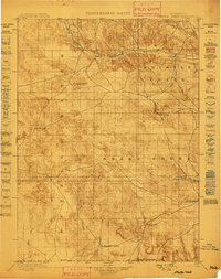
 1898 Camp Clarke1898 Print · USGSThe Nebraska panhandle in the late nineteenth century is documented here through its early irrigation canals and iconic trail landmarks. Researchers can trace early settlements like Camp Clarke and Bayard alongside famous geologic features including Chimney Rock and Courthouse Rock.5 unique versions available
 - 1899 Map of Goshen Hole
 1899 Goshen Hole1899 Print · USGSThe High Plains of the Wyoming-Nebraska borderlands come into focus at the close of the nineteenth century. Researchers can trace the early cattle ranching economy through named homesteads like Greasewood Ranch and Robb's Ranch, and locate landmarks such as Ninemile Rock.4 unique versions available
 - 1899 Map of Whistle Creek
 1899 Whistle Creek1899 Print · USGSSioux County's ranching frontier is frozen in time during the late nineteenth century, showing a landscape where water meant survival. Genealogists and historians can trace old wagon routes like the Spottedtail Trail and find early cattle outposts like Agate and Corbin's Ranch.4 unique versions available
End of results
Showing maps 1-5 of 5
Top cities of Scotts Bluff County
- Scottsbluff historical maps
- Gering historical maps
- Mitchell historical maps
- Terrytown historical maps
- Morrill historical maps
- Minatare historical maps
See more
Frequently asked questions
- What are the different types of historical maps available for Scotts Bluff County?
- What is the oldest map of Scotts Bluff County?
- Where can I purchase historical maps of Scotts Bluff County for my home or office?
- Where can I download high-res historical maps of Scotts Bluff County?
- Are there historical topographic maps available for Scotts Bluff County?
- Is there historical aerial imagery available for Scotts Bluff County?
- Where are historical maps of Scotts Bluff County sourced from?