1970s Maps of Scotts Bluff County, Nebraska
Explore 7 historic maps of Scotts Bluff County from the 1970s. These maps offer a rare glimpse into what life looked like during the 1970s — showing old roads, neighborhoods, homes, and landmarks that have changed or disappeared over time.
Whether you're researching your family's past, planning a metal detecting trip, or studying how Scotts Bluff County's landscape evolved across the 1970s, these high-resolution maps are a powerful tool for exploring the history of this region.
- Focus on a specific era: All maps on this page are from the 1970s, giving you a focused view of this time period.
- See what’s changed: Compare century-old streets, trails, and buildings to today's modern landscape using overlays and satellite layers.
- Research with precision: Use these maps for genealogy, historical research, land use analysis, or educational projects.
- View, download, or print: Maps are fully viewable online in high resolution, and can be downloaded or printed for your own records.
Start exploring Scotts Bluff County's history through authentic maps from the 1970s. This is your window into the past.
Scotts Bluff County, NE maps
(7)- 1973 Map of Scotts Bluff 4 NW, 1974 Print
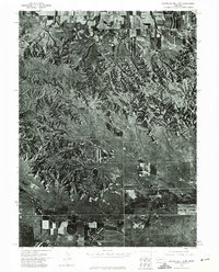 1973 Scotts Bluff 4 NW1974 Print · USGSBanner County in the early seventies is documented here through high-resolution aerial imagery rather than traditional line drawing. You can trace the path of the Fort Laramie Canal and the natural terrain around Hogback Mountain and Pumpkin Creek.
 - 1973 Map of Scotts Bluff 4 NE, 1974 Print
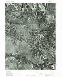 1973 Scotts Bluff 4 NE1974 Print · USGSBanner County, Nebraska, comes into sharp focus in the early 1970s through high-altitude aerial photography. Trace the winding path of Pumpkin Creek and study the detailed patterns of agricultural development across this rural landscape.
 - 1973 Map of Scotts Bluff 3 NE, 1975 Print
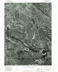 1973 Scotts Bluff 3 NE1975 Print · USGSBanner County agriculture and the rugged Nebraska panhandle terrain meet in the early seventies along the banks of Pumpkin Creek. Researchers can examine the detailed aerial layout of center-pivot irrigation fields and the natural drainage of the tablelands.
 - 1978 Map of Torrington
 1978 Torrington1978 Print · USGSSoutheast Wyoming in the late seventies reveals a landscape shaped by the North Platte River and a dense network of major rail lines. Researchers can locate the Fort Laramie National Historic Site, the Camp Guernsey Training Area, and original stops along the Union Pacific railroad.2 unique versions available
 - 1979 Map of Wright Gap
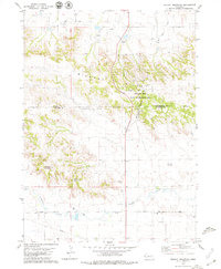
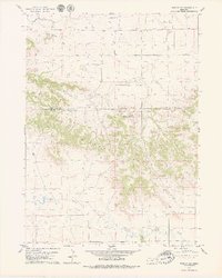 1979 Wright Gap1979 Print · USGSThe Wildcat Hills straddle the Banner and Scotts Bluff county line in the late seventies, showing a landscape defined by ranching and irrigation. Family historians and researchers can locate Creighton Cem and trace early routes like Pumpkin Creek Road near Castle Rock.
 - 1979 Map of Wildcat Mountain
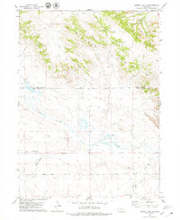
 1979 Wildcat Mountain1979 Print · USGSHigh plains ranching and energy extraction meet in the late 1970s along the Scotts Bluff and Banner County line. Trace local landmarks like Wildcat Mountain and Funnel Rock alongside the industrial footprint of the Henderson Oil Field.
 - 1979 Map of Murray Lake NE
 1979 Murray Lake NE1979 Print · USGSThe Nebraska Panhandle's cattle country and energy landscape are captured here in the late seventies. Genealogists and local historians can trace the paths of Pumpkin Creek, locate early oil exploration sites like the Oil Well, and identify landmarks such as Clay Springs.
End of results
Showing maps 1-7 of 7
Top cities of Scotts Bluff County
- Scottsbluff historical maps
- Gering historical maps
- Mitchell historical maps
- Terrytown historical maps
- Morrill historical maps
- Minatare historical maps
See more
Frequently asked questions
- What are the different types of historical maps available for Scotts Bluff County?
- What is the oldest map of Scotts Bluff County?
- Where can I purchase historical maps of Scotts Bluff County for my home or office?
- Where can I download high-res historical maps of Scotts Bluff County?
- Are there historical topographic maps available for Scotts Bluff County?
- Is there historical aerial imagery available for Scotts Bluff County?
- Where are historical maps of Scotts Bluff County sourced from?