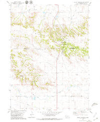
1979 Map of Wildcat Mountain
USGS Topo · Published 1979About this map
The rugged topography of the Wildcat Hills dominates this western Nebraska landscape, where the Scotts Bluff and Banner County line divides a terrain defined by steep ridges and dry canyons. Land use in the late 1970s shows a clear contrast between preservation and extraction, as the Wildcat Hills State Recreation Area sits adjacent to the active Henderson Oil Field. This juxtaposition highlights the region's dual identity as both a recreational landmark and an energy-producing zone, with numerous Oil Wells and a Pipeline cutting through the valleys.
Find a feature on this map
22 named features on this map. Tap any name to fly to it.
Don’t see what you’re looking for? This feature index may not catch every label — zoom into the map to look around manually.
Map Details
Editions of this 1979 Wildcat Mountain Map
This is the sole edition of this map. No revisions or reprints were ever made.
Other maps of this area

1898 · Scotts Bluff
USGS Topo · 1:125,000

1954 · Scottsbluff
USGS Topo · 1:250,000

1958 · Scottsbluff
USGS Topo · 1:250,000

1963 · Scottsbluff South
USGS Topo · 1:24,000

1963 · Roubadeau Pass
USGS Topo · 1:24,000

1965 · Minatare
USGS Topo · 1:24,000

1973 · Scotts Bluff 4 NW
USGS Topo · 1:24,000

1973 · Scotts Bluff 4 SE
USGS Topo · 1:24,000

1973 · Scotts Bluff 4 NE
USGS Topo · 1:24,000

1973 · Scotts Bluff 4 SW
USGS Topo · 1:24,000