1980s Maps of York County, Nebraska
Explore 2 historic maps of York County from the 1980s. These maps offer a rare glimpse into what life looked like during the 1980s — showing old roads, neighborhoods, homes, and landmarks that have changed or disappeared over time.
Whether you're researching your family's past, planning a metal detecting trip, or studying how York County's landscape evolved across the 1980s, these high-resolution maps are a powerful tool for exploring the history of this region.
- Focus on a specific era: All maps on this page are from the 1980s, giving you a focused view of this time period.
- See what’s changed: Compare century-old streets, trails, and buildings to today's modern landscape using overlays and satellite layers.
- Research with precision: Use these maps for genealogy, historical research, land use analysis, or educational projects.
- View, download, or print: Maps are fully viewable online in high resolution, and can be downloaded or printed for your own records.
Start exploring York County's history through authentic maps from the 1980s. This is your window into the past.
York County, NE maps
(2)- 1985 Map of David City
 1985 David City1985 Print · USGSCentral Nebraska in the mid-eighties centers on the convergence of the Platte River and Loup River. Trace the rail-and-river economy through towns like Columbus, David City, and Stromsburg, or locate family sites near Swedehome and Surprise.2 unique versions available
 - 1985 Map of York
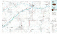
 1985 York1985 Print · USGSSoutheast Nebraska in the mid-1980s shows a landscape of productive plains and vital transport corridors along the Burlington Northern line. Trace the history of local institutions like Concordia Teachers College and find family sites at Greenwood Cem or Thayer Cem.2 unique versions available
End of results
Showing maps 1-2 of 2
Top cities of York County
- York historical maps
- Henderson historical maps
- McCool Junction historical maps
- Bradshaw historical maps
- Benedict historical maps
- Waco historical maps
See more
Frequently asked questions
- What are the different types of historical maps available for York County?
- What is the oldest map of York County?
- Where can I purchase historical maps of York County for my home or office?
- Where can I download high-res historical maps of York County?
- Are there historical topographic maps available for York County?
- Is there historical aerial imagery available for York County?
- Where are historical maps of York County sourced from?