1950s Maps of Enterprise, Clark County
Explore 8 historic maps of Enterprise from the 1950s. These maps offer a rare glimpse into what life looked like during the 1950s — showing old roads, neighborhoods, homes, and landmarks that have changed or disappeared over time.
Whether you're researching your family's past, planning a metal detecting trip, or studying how Enterprise's landscape evolved across the 1950s, these high-resolution maps are a powerful tool for exploring the history of this region.
- Focus on a specific era: All maps on this page are from the 1950s, giving you a focused view of this time period.
- See what’s changed: Compare century-old streets, trails, and buildings to today's modern landscape using overlays and satellite layers.
- Research with precision: Use these maps for genealogy, historical research, land use analysis, or educational projects.
- View, download, or print: Maps are fully viewable online in high resolution, and can be downloaded or printed for your own records.
Start exploring Enterprise's history through authentic maps from the 1950s. This is your window into the past.
Enterprise, Clark County maps
(8)- 1952 Map of Blue Diamond, 1953 Print
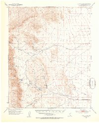 1952 Blue Diamond1953 Print · USGSBlue Diamond and the surrounding Nevada desert appear here in the early fifties during a period of active quarrying and ranching. Genealogists and historians can trace family-named outposts like Bar Nothing Ranch or Oliver Ranch and locate early industry at the Blue Diamond Mine.5 unique versions available
 - 1952 Map of Las Vegas, 1956 Print
 1952 Las Vegas1956 Print · USGSLas Vegas and its early suburbs are captured here in the early fifties during a period of rapid post-war aviation and industrial expansion. Researchers can trace family-named sites like Warm Springs Ranch and vanished landmarks like the Las Vegas Race Track or Mc Carran Field.
 - 1954 Map of Las Vegas
 1954 Las Vegas1954 Print · USGSLas Vegas and the Mojave Desert are shown in the early fifties as the region's military and recreational footprint expanded. Genealogists and historians can trace the early layout of North Las Vegas, the sites of Indian Springs Air Force Base, and long-established towns like Bunkerville.5 unique versions available
 - 1954 Map of Kingman, 1964 Print
 1954 Kingman1964 Print · USGSThe High Desert borderlands come to life in the mid-fifties, showing the intersection of mining legacies and massive river projects. Researchers can trace old rail stops like Roach Station, mining sites such as Chloride, and river landmarks like Searchlight Ferry.4 unique versions available
 - 1955 Map of Kingman
 1955 Kingman1955 Print · USGSThe Mojave Desert and Colorado River corridor come alive in the mid-fifties, showing a landscape of mining camps and rail junctions. Trace the river to the Searchlight Ferry or locate old desert mining sites like Goldroad and the Great Monster Mine.
 - 1957 Map of Las Vegas
 1957 Las Vegas1957 Print · USGSSouthern Nevada in the mid-fifties is a landscape of massive federal ranges and the early growth of Las Vegas. Researchers can trace the development of McCarran Field, the expansive Lake Mead National Recreation Area, and the industrial footprint of Henderson.
 - 1958 Map of Kingman
 1958 Kingman1958 Print · USGSThe tri-state desert borders of Arizona, Nevada, and California are shown in the late fifties as a network of mining camps and river crossings. Genealogists and historians can trace the legacy of remote outposts like Oatman, Chloride, and the Searchlight Ferry along the Colorado River.2 unique versions available
 - 1959 Map of Las Vegas
 1959 Las Vegas1959 Print · USGSSouthern Nevada in the late fifties was a landscape of rapid suburban growth and massive federal installations. Genealogists and historians can trace early housing at Victory Village, the grounds of Camp Desert Rock, and the remote Tule Springs Ranch.
End of results
Showing maps 1-8 of 8
Frequently asked questions
- What are the different types of historical maps available for Enterprise?
- What is the oldest map of Enterprise?
- Where can I purchase historical maps of Enterprise for my home or office?
- Where can I download high-res historical maps of Enterprise?
- Are there historical topographic maps available for Enterprise?
- Is there historical aerial imagery available for Enterprise?
- Where are historical maps of Enterprise sourced from?