1960s Maps of Enterprise, Clark County
Explore 5 historic maps of Enterprise from the 1960s. These maps offer a rare glimpse into what life looked like during the 1960s — showing old roads, neighborhoods, homes, and landmarks that have changed or disappeared over time.
Whether you're researching your family's past, planning a metal detecting trip, or studying how Enterprise's landscape evolved across the 1960s, these high-resolution maps are a powerful tool for exploring the history of this region.
- Focus on a specific era: All maps on this page are from the 1960s, giving you a focused view of this time period.
- See what’s changed: Compare century-old streets, trails, and buildings to today's modern landscape using overlays and satellite layers.
- Research with precision: Use these maps for genealogy, historical research, land use analysis, or educational projects.
- View, download, or print: Maps are fully viewable online in high resolution, and can be downloaded or printed for your own records.
Start exploring Enterprise's history through authentic maps from the 1960s. This is your window into the past.
Enterprise, Clark County maps
(5)- 1960 Map of Kingman
 1960 Kingman1960 Print · USGSThe high desert landscape of the Arizona-Nevada border comes alive in the mid-twentieth century, showcasing the rise of recreation alongside deep-rooted mining history. Genealogists and historians can trace the roots of towns like Kingman and Oatman, or locate remote sites like the Lucky Dutchman Mine and Santa Claus.3 unique versions available
 - 1960 Map of Goodsprings, 1961 Print
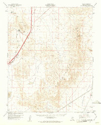
 1960 Goodsprings1961 Print · USGSIn the arid desert of southern Nevada during the early sixties, the mining district around Goodsprings remains a prominent fixture of the landscape. Researchers can trace dozens of specific claims like the Yellow Pine Mine and Bluejay Mine, or locate the isolated settlement of Jean near the Union Pacific tracks.2 unique versions available
 - 1960 Map of Sloan, 1961 Print
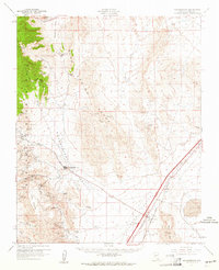
 1960 Sloan1961 Print · USGSThe Clark County desert comes into focus in the early 1960s as a corridor of rail industry and mountain terrain. Trace the Union Pacific line through Sloan and Erie, or locate industrial landmarks like the Quarries and the Bard (Site).3 unique versions available
 - 1962 Map of Las Vegas
 1962 Las Vegas1962 Print · USGSSouthern Nevada is captured here during a period of significant military and industrial growth in the early sixties. Researchers can trace the development of Las Vegas alongside the Magnesium Plant in Henderson and the expansive Nellis Air Force Base.
 - 1967 Map of Las Vegas SW, 1968 Print
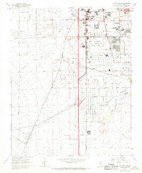 1967 Las Vegas SW1968 Print · USGSThe southern Las Vegas valley in the mid-1960s was a desert landscape undergoing a dramatic industrial and recreational transformation. Local historians can trace early landmarks like the Stardust International Raceway and the Union Pacific Railroad stops at Arden and Bracken.5 unique versions available
End of results
Showing maps 1-5 of 5
Frequently asked questions
- What are the different types of historical maps available for Enterprise?
- What is the oldest map of Enterprise?
- Where can I purchase historical maps of Enterprise for my home or office?
- Where can I download high-res historical maps of Enterprise?
- Are there historical topographic maps available for Enterprise?
- Is there historical aerial imagery available for Enterprise?
- Where are historical maps of Enterprise sourced from?