1900s (20th Century) Maps of Mesquite, Nevada
Explore 10 historic maps of Mesquite from the 1900s (20th Century). These maps offer a rare glimpse into what life looked like during the 1900s — showing old roads, neighborhoods, homes, and landmarks that have changed or disappeared over time.
Whether you're researching your family's past, planning a metal detecting trip, or studying how Mesquite's landscape evolved across the 1900s, these high-resolution maps are a powerful tool for exploring the history of this region.
- Focus on a specific era: All maps on this page are from the 1900s, giving you a focused view of this time period.
- See what’s changed: Compare century-old streets, trails, and buildings to today's modern landscape using overlays and satellite layers.
- Research with precision: Use these maps for genealogy, historical research, land use analysis, or educational projects.
- View, download, or print: Maps are fully viewable online in high resolution, and can be downloaded or printed for your own records.
Start exploring Mesquite's history through authentic maps from the 1900s. This is your window into the past.
Mesquite, NV maps
(10)- 1954 Map of Las Vegas
 1954 Las Vegas1954 Print · USGSLas Vegas and the Mojave Desert are shown in the early fifties as the region's military and recreational footprint expanded. Genealogists and historians can trace the early layout of North Las Vegas, the sites of Indian Springs Air Force Base, and long-established towns like Bunkerville.5 unique versions available
 - 1957 Map of Las Vegas
 1957 Las Vegas1957 Print · USGSSouthern Nevada in the mid-fifties is a landscape of massive federal ranges and the early growth of Las Vegas. Researchers can trace the development of McCarran Field, the expansive Lake Mead National Recreation Area, and the industrial footprint of Henderson.
 - 1957 Map of Mesquite, 1959 Print
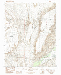
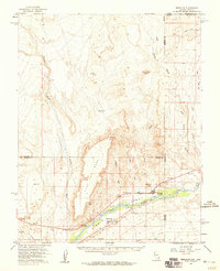 1957 Mesquite1959 Print · USGSMesquite and the Virgin River valley appear here in the late fifties, during a period of steady growth along the old highway corridors. Researchers can trace the layout of early Bunkerville and Mesquite, locating the cemetery, local Airport, and various water controls along the Virgin River.2 unique versions available
 - 1958 Map of Virgin Peak, 1960 Print
 1958 Virgin Peak1960 Print · USGSThe Nevada-Arizona border country comes to life in the late fifties, showing the high ridges of the Virgin Mountains. Researchers can trace old desert outposts like Juanita Springs Ranch and Whitney Ranch, or locate historic Petroglyphs and the Great Western Mine.2 unique versions available
 - 1959 Map of Las Vegas
 1959 Las Vegas1959 Print · USGSSouthern Nevada in the late fifties was a landscape of rapid suburban growth and massive federal installations. Genealogists and historians can trace early housing at Victory Village, the grounds of Camp Desert Rock, and the remote Tule Springs Ranch.
 - 1962 Map of Las Vegas
 1962 Las Vegas1962 Print · USGSSouthern Nevada is captured here during a period of significant military and industrial growth in the early sixties. Researchers can trace the development of Las Vegas alongside the Magnesium Plant in Henderson and the expansive Nellis Air Force Base.
 - 1983 Map of Riverside, 1984 Print
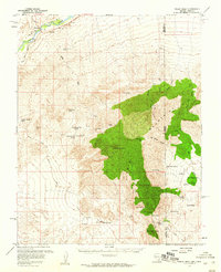
 1983 Riverside1984 Print · USGSNortheastern Clark County was still a land of remote ranching and mining outposts in the early eighties. Researchers can trace the legacy of early desert life through landmarks like Juanita Springs Ranch, the Great Eastern Mine, and the waters of North Key West Spring.
 - 1985 Map of Mesquite
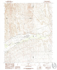 1985 Mesquite1985 Print · USGSThe Virgin River valley at the Nevada-Arizona border shows its agricultural roots and desert landscape in the mid-eighties. Genealogists and researchers can trace local infrastructure through the Mesquite Flume Ditch and locations like the Cem and Bunkerville.
 - 1985 Map of Flat Top Mesa
 1985 Flat Top Mesa1985 Print · USGSBunkerville and the Virgin River valley are captured in the mid-1980s as agricultural life persisted between towering desert plateaus. Researchers can trace the path of the Bunkerville Ditch and explore the rugged borders of Flat Top Mesa and Mormon Mesa.
 - 1987 Map of Overton, 1988 Print
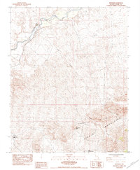
 1987 Overton1988 Print · USGSSoutheastern Nevada at the end of the 1980s reveals a desert landscape of river-valley settlements and vast public lands. Trace the Union Pacific line through Moapa or locate family sites in Logandale and Bunkerville along the Virgin River.2 unique versions available
End of results
Showing maps 1-10 of 10
Top cities near Mesquite
Top neighborhoods of Mesquite
- Chardonnay Townhomes historical maps
- Coronado historical maps
- Santa Fe Vistas historical maps
- Crestview Townhomes historical maps
- Scenic View Townhomes historical maps
- Desert Shade Apartments historical maps
See more
Frequently asked questions
- What are the different types of historical maps available for Mesquite?
- What is the oldest map of Mesquite?
- Where can I purchase historical maps of Mesquite for my home or office?
- Where can I download high-res historical maps of Mesquite?
- Are there historical topographic maps available for Mesquite?
- Is there historical aerial imagery available for Mesquite?
- Where are historical maps of Mesquite sourced from?