1970s Maps of North Las Vegas, Nevada
Explore 4 historic maps of North Las Vegas from the 1970s. These maps offer a rare glimpse into what life looked like during the 1970s — showing old roads, neighborhoods, homes, and landmarks that have changed or disappeared over time.
Whether you're researching your family's past, planning a metal detecting trip, or studying how North Las Vegas's landscape evolved across the 1970s, these high-resolution maps are a powerful tool for exploring the history of this region.
- Focus on a specific era: All maps on this page are from the 1970s, giving you a focused view of this time period.
- See what’s changed: Compare century-old streets, trails, and buildings to today's modern landscape using overlays and satellite layers.
- Research with precision: Use these maps for genealogy, historical research, land use analysis, or educational projects.
- View, download, or print: Maps are fully viewable online in high resolution, and can be downloaded or printed for your own records.
Start exploring North Las Vegas's history through authentic maps from the 1970s. This is your window into the past.
North Las Vegas, NV maps
(4)- 1973 Map of Las Vegas NE, 1977 Print
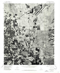 1973 Las Vegas NE1977 Print · USGSThe Mojave Desert meets rapid urban growth in the early 1970s as the Las Vegas valley expands toward the northeast. Trace the early development of North Las Vegas and the sprawling footprint of Nellis Air Force Base before the modern housing boom.
 - 1973 Map of Las Vegas NW, 1978 Print
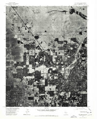 1973 Las Vegas NW1978 Print · USGSThe Nevada desert meets rapid suburban expansion in the early 1970s as residential grids push across the valley floor. Trace the development of Las Vegas and North Las Vegas, including the runways of the North Las Vegas Air Terminal.
 - 1974 Map of Gass Peak SW, 1977 Print
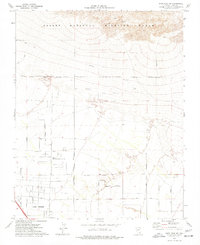 1974 Gass Peak SW1977 Print · USGSLas Vegas began its northward expansion into the high desert during the 1970s, as shown in this detailed survey. Researchers can trace the early city grid along Rainbow Blvd or locate local landmarks like the Home of the Good Shepherd and the June Bug Mine.3 unique versions available
 - 1974 Map of Valley, 1977 Print
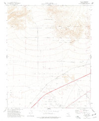 1974 Valley1977 Print · USGSSouthern Nevada in the mid-seventies shows a landscape defined by federal land use and early infrastructure. Researchers can trace the intersection of the Union Pacific railroad with military outposts like Nellis AFB and the small settlements of Valley and Lovell.2 unique versions available
End of results
Showing maps 1-4 of 4
Top cities near North Las Vegas
- Las Vegas historical maps
- Henderson historical maps
- Enterprise historical maps
- Spring Valley historical maps
- Sunrise Manor historical maps
- Paradise historical maps
See more
Top neighborhoods of North Las Vegas
- Craig Ranch historical maps
- Aliante historical maps
- Villages at Tule Springs historical maps
- Heartland historical maps
Frequently asked questions
- What are the different types of historical maps available for North Las Vegas?
- What is the oldest map of North Las Vegas?
- Where can I purchase historical maps of North Las Vegas for my home or office?
- Where can I download high-res historical maps of North Las Vegas?
- Are there historical topographic maps available for North Las Vegas?
- Is there historical aerial imagery available for North Las Vegas?
- Where are historical maps of North Las Vegas sourced from?