1940s Maps of Eureka County, Nevada
Explore 5 historic maps of Eureka County from the 1940s. These maps offer a rare glimpse into what life looked like during the 1940s — showing old roads, neighborhoods, homes, and landmarks that have changed or disappeared over time.
Whether you're researching your family's past, planning a metal detecting trip, or studying how Eureka County's landscape evolved across the 1940s, these high-resolution maps are a powerful tool for exploring the history of this region.
- Focus on a specific era: All maps on this page are from the 1940s, giving you a focused view of this time period.
- See what’s changed: Compare century-old streets, trails, and buildings to today's modern landscape using overlays and satellite layers.
- Research with precision: Use these maps for genealogy, historical research, land use analysis, or educational projects.
- View, download, or print: Maps are fully viewable online in high resolution, and can be downloaded or printed for your own records.
Start exploring Eureka County's history through authentic maps from the 1940s. This is your window into the past.
Eureka County, NV maps
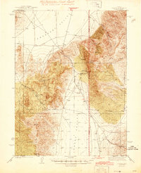
(5)- 1943 Map of Mineral Hill
 1943 Mineral Hill1943 Print · USGSCentral Nevada's mining and ranching corridor is documented here during the late 1930s as the rail era transitioned into memory. Researchers can trace the Nevada Eureka (Abandoned) rail line past Alpha Ranch and locate early sites like Mineral Hill and the Bell Mine.2 unique versions available
 - 1944 Map of Cortez
 1944 Cortez1944 Print · USGSLander and Eureka counties are documented here in the early 1940s, highlighting the mining and ranching outposts of the Great Basin. Genealogists and historians can trace family locations at Caetano Ranch or explore industrial sites like the Cortez Mine and the Mill Canyon Sch.2 unique versions available
 - 1949 Map of Garden Valley, 1958 Print
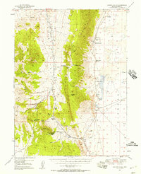 1949 Garden Valley1958 Print · USGSGarden Valley and the surrounding peaks are shown here in the late 1940s as a landscape of isolated Nevada ranches and mining prospects. Genealogists and historians can trace family operations like Bailey Ranch or locate the remote Diamond Valley School and the Mt Hope Mine.3 unique versions available
 - 1949 Map of Crescent Valley, 1958 Print
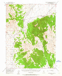
 1949 Crescent Valley1958 Print · USGSCrescent Valley and the surrounding ranges are shown here in the late 1940s as a landscape of mining and ranching. Trace old mining operations at the Gold Acres Mine, find the Lander (Site), or locate the Dean Ranch.2 unique versions available
 - 1949 Map of Roberts Creek Mtn, 1963 Print
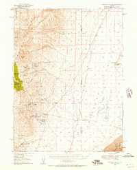
 1949 Roberts Creek Mtn1963 Print · USGSThe high Nevada rangelands of Eureka County are captured here in the late 1940s, showing a world of remote cattle ranches and mountain passes. Genealogists and historians can trace family-named outposts like Roberts Creek Ranch and Willow Creek Ranch or locate the old Prospect near Jackass Creek Canyon.3 unique versions available
End of results
Showing maps 1-5 of 5
Top cities of Eureka County
Frequently asked questions
- What are the different types of historical maps available for Eureka County?
- What is the oldest map of Eureka County?
- Where can I purchase historical maps of Eureka County for my home or office?
- Where can I download high-res historical maps of Eureka County?
- Are there historical topographic maps available for Eureka County?
- Is there historical aerial imagery available for Eureka County?
- Where are historical maps of Eureka County sourced from?