1900s (20th Century) Maps of Eureka County, Nevada
Explore 150 historic maps of Eureka County from the 1900s (20th Century). These maps offer a rare glimpse into what life looked like during the 1900s — showing old roads, neighborhoods, homes, and landmarks that have changed or disappeared over time.
Whether you're researching your family's past, planning a metal detecting trip, or studying how Eureka County's landscape evolved across the 1900s, these high-resolution maps are a powerful tool for exploring the history of this region.
- Focus on a specific era: All maps on this page are from the 1900s, giving you a focused view of this time period.
- See what’s changed: Compare century-old streets, trails, and buildings to today's modern landscape using overlays and satellite layers.
- Research with precision: Use these maps for genealogy, historical research, land use analysis, or educational projects.
- View, download, or print: Maps are fully viewable online in high resolution, and can be downloaded or printed for your own records.
Start exploring Eureka County's history through authentic maps from the 1900s. This is your window into the past.
Eureka County, NV maps
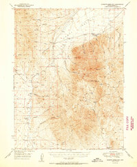
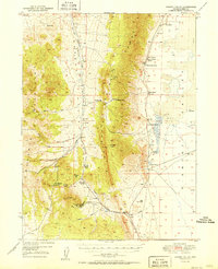
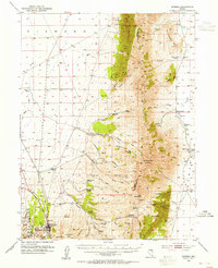
(150)- 1926 Map of Roberts Mountains, 1955 Print
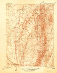
 1926 Roberts Mountains1955 Print · USGSCentral Nevada in the mid-1920s is a landscape of remote mountain ranges and isolated valley ranching. Genealogists and historians can trace family-named locations like Hall Creek Ranch, Sadler Sch, and the Keystone Mine across the high desert.
 - 1929 Map of Roberts Mountains
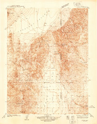
 1929 Roberts Mountains1929 Print · USGSCentral Nevada in the late 1920s reveals a vast ranching and mining landscape organized around vital water sources. Researchers can trace early family outposts like Roberts Creek Ranch and Grubbs Ranch or locate remote schools such as Simpson Park Sch.4 unique versions available
 - 1934 Map of Jiggs, 1955 Print
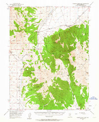
 1934 Jiggs1955 Print · USGSElko County ranching life in the 1930s is preserved here, centered on the small hub of Jiggs and the high peaks of the Ruby Mountains. Researchers can locate dozens of family-named sites, from Zunino Ranch to the Davis Ranch Hobson Post Office and the remote Johnson Cabin.
 - 1937 Map of Mineral Hill
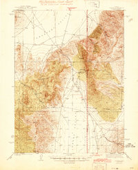
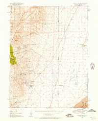
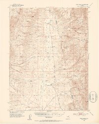
 1937 Mineral Hill1937 Print · USGSEureka County mining and ranching operations are documented here in the late 1930s as the Eureka Nevada RR served the high desert. Researchers can trace historic family-named sites like Bruffey Ranch and the workings at the Old Whalen Mine.4 unique versions available
 - 1937 Map of Jiggs
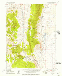
 1937 Jiggs1937 Print · USGSElko County ranching life is preserved here during the 1930s, when isolated family homesteads were the primary anchors of the high desert landscape. Genealogists and historians can trace the locations of the Davis Ranch Hobson PO, the Smith Creek Sch, and the Harrison Pass Ranger Sta.2 unique versions available
 - 1938 Map of Cortez
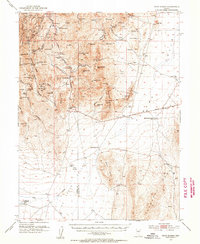
 1938 Cortez1938 Print · USGSThe high-desert mining district of Lander and Eureka counties is captured here in the late 1930s. Researchers can locate remote mountain infrastructure like the Cortez Mine, Mill Canyon Sch, and several family-named outposts including Caetano Ranch.4 unique versions available
 - 1943 Map of Mineral Hill
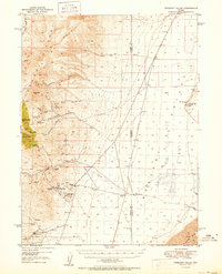
 1943 Mineral Hill1943 Print · USGSCentral Nevada's mining and ranching corridor is documented here during the late 1930s as the rail era transitioned into memory. Researchers can trace the Nevada Eureka (Abandoned) rail line past Alpha Ranch and locate early sites like Mineral Hill and the Bell Mine.2 unique versions available
 - 1944 Map of Cortez
 1944 Cortez1944 Print · USGSLander and Eureka counties are documented here in the early 1940s, highlighting the mining and ranching outposts of the Great Basin. Genealogists and historians can trace family locations at Caetano Ranch or explore industrial sites like the Cortez Mine and the Mill Canyon Sch.2 unique versions available
 - 1949 Map of Garden Valley, 1958 Print
 1949 Garden Valley1958 Print · USGSGarden Valley and the surrounding peaks are shown here in the late 1940s as a landscape of isolated Nevada ranches and mining prospects. Genealogists and historians can trace family operations like Bailey Ranch or locate the remote Diamond Valley School and the Mt Hope Mine.3 unique versions available
 - 1949 Map of Crescent Valley, 1958 Print
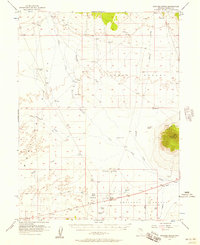
 1949 Crescent Valley1958 Print · USGSCrescent Valley and the surrounding ranges are shown here in the late 1940s as a landscape of mining and ranching. Trace old mining operations at the Gold Acres Mine, find the Lander (Site), or locate the Dean Ranch.2 unique versions available
 - 1949 Map of Roberts Creek Mtn, 1963 Print
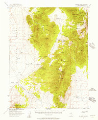
 1949 Roberts Creek Mtn1963 Print · USGSThe high Nevada rangelands of Eureka County are captured here in the late 1940s, showing a world of remote cattle ranches and mountain passes. Genealogists and historians can trace family-named outposts like Roberts Creek Ranch and Willow Creek Ranch or locate the old Prospect near Jackass Creek Canyon.3 unique versions available
 - 1950 Map of Crescent Valley
 1950 Crescent Valley1950 Print · USGSCrescent Valley at the mid-century reveals a landscape of active gold mining and earlier silver-era relics. Researchers can trace the lineage of local mining at the Gold Acres Mine or locate the historic town of Tenabo and the Lander (Site).2 unique versions available
 - 1951 Map of Roberts Creek Mtn
 1951 Roberts Creek Mtn1951 Print · USGSIn the early fifties, the remote ranching country of Eureka County was a land of high peaks and vital water holes. Researchers can trace the heritage of local landholdings at Indian Ranch and Roberts Creek Ranch or find mineral history near the Prospect by Jackass Creek.2 unique versions available
 - 1951 Map of Garden Valley
 1951 Garden Valley1951 Print · USGSCentral Nevada's high desert ranching and mining life are documented here during the mid-century. Researchers can trace ancestral property lines and mineral ventures at Siri Ranch, the Diamond Valley School, and the Mt Hope Mine.2 unique versions available
 - 1952 Map of Pine Valley, 1954 Print
 1952 Pine Valley1954 Print · USGSPine Valley and the surrounding mountains are documented here in the early fifties, showing the high-desert ranching life of the Great Basin. Genealogists and historians can trace family properties like Slagowski Ranch or locate the Indian Campground and Dismantled Railroad.4 unique versions available
 - 1952 Map of Carlin, 1954 Print
 1952 Carlin1954 Print · USGSThe Nevada high desert meets the iron rail in the early 1950s as the Southern Pacific and Western Pacific navigate the Humboldt River corridor. Researchers can trace historic routes like the California Trail or locate family sites like Raine Ranch and Thomas Place.5 unique versions available
 - 1953 Map of Pinto Summit, 1955 Print
 1953 Pinto Summit1955 Print · USGSThe high desert of Eureka and White Pine Counties is shown here in the 1950s as a landscape of deep mines and remote outposts. Researchers can trace the legacy of mining at the Windfall Mine or find historical locations like Eighteenmile House (Site) and Schaefer Ranch.4 unique versions available
 - 1953 Map of Eureka, 1955 Print
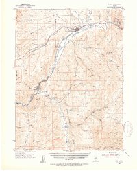
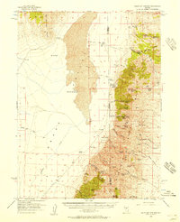
 1953 Eureka1955 Print · USGSThe Nevada mining town of Eureka is shown at mid-century during a period of transition for the high desert silver-lead district. Genealogists and historians can locate numerous family holdings such as Palmer Ranch and trace the path of the Eureka Nevada RR past the historic Charcoal Kiln.3 unique versions available
 - 1955 Map of McDermitt
 1955 McDermitt1955 Print · USGSNorthern Nevada in the mid-fifties shows a landscape of mining camps and vast cattle ranges. Trace the early footprints of Tuscarora or the remote Cordero Mine and National Mine tucked into the high desert peaks.3 unique versions available
 - 1955 Map of Millett, 1963 Print
 1955 Millett1963 Print · USGSCentral Nevada in the mid-fifties is a landscape of high-desert basins and remote outposts. Researchers can trace historic ranching sites like Petersons Mill and Grass Valley Ranch or locate the McCoy Mining Camp.4 unique versions available
 - 1955 Map of Winnemucca, 1968 Print
 1955 Winnemucca1968 Print · USGSNorthern Nevada's high desert corridor is captured here in the mid-fifties, centered on the river-and-rail hub of Winnemucca. Researchers can trace the dual tracks of the Southern Pacific and Western Pacific railroads through towns like Golconda and Valmy.3 unique versions available
 - 1955 Map of Elko, 1974 Print
 1955 Elko1974 Print · USGSNortheastern Nevada in the mid-fifties is captured here as a crossroads of transcontinental rail and high desert ranching. Trace old rail stops from Wells to Elko or find remote landmarks like Shanty Town and Medicine Spring.3 unique versions available
 - 1956 Map of Bellevue Peak, 1957 Print
 1956 Bellevue Peak1957 Print · USGSThe Nevada high desert in the mid-1950s was a landscape defined by isolated mines and vital springs. Researchers can find historical landmarks like the Fenstermaker Grave and old workings at the Mountain Boy Mine or Angelo Belli Mine.3 unique versions available
 - 1956 Map of Bartine Ranch, 1957 Print
 1956 Bartine Ranch1957 Print · USGSEureka County ranching and mining operations are captured in the mid-1950s across the expanse of the Kobe and Antelope Valleys. Researchers can trace historic property locations like Bartine Ranch or locate early mineral activity at Lone Mtn Mine and Prospects.3 unique versions available
 - 1956 Map of Walti Hot Springs, 1957 Print
 1956 Walti Hot Springs1957 Print · USGSThe high desert of central Nevada is captured here in the mid-1950s, showing the remote ranching outposts along the Simpson Park Range. You can trace early jeep trails and family landmarks like Walti Ranch, Keystone Mine, and the thermal Hot Springs.2 unique versions available
Showing maps 1-25 of 150
Top cities of Eureka County
Frequently asked questions
- What are the different types of historical maps available for Eureka County?
- What is the oldest map of Eureka County?
- Where can I purchase historical maps of Eureka County for my home or office?
- Where can I download high-res historical maps of Eureka County?
- Are there historical topographic maps available for Eureka County?
- Is there historical aerial imagery available for Eureka County?
- Where are historical maps of Eureka County sourced from?