1950s Maps of Winnemucca, Nevada
Explore 4 historic maps of Winnemucca from the 1950s. These maps offer a rare glimpse into what life looked like during the 1950s — showing old roads, neighborhoods, homes, and landmarks that have changed or disappeared over time.
Whether you're researching your family's past, planning a metal detecting trip, or studying how Winnemucca's landscape evolved across the 1950s, these high-resolution maps are a powerful tool for exploring the history of this region.
- Focus on a specific era: All maps on this page are from the 1950s, giving you a focused view of this time period.
- See what’s changed: Compare century-old streets, trails, and buildings to today's modern landscape using overlays and satellite layers.
- Research with precision: Use these maps for genealogy, historical research, land use analysis, or educational projects.
- View, download, or print: Maps are fully viewable online in high resolution, and can be downloaded or printed for your own records.
Start exploring Winnemucca's history through authentic maps from the 1950s. This is your window into the past.
Winnemucca, NV maps
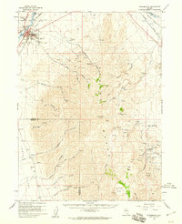
(4)- 1955 Map of Winnemucca, 1968 Print
 1955 Winnemucca1968 Print · USGSNorthern Nevada's high desert corridor is captured here in the mid-fifties, centered on the river-and-rail hub of Winnemucca. Researchers can trace the dual tracks of the Southern Pacific and Western Pacific railroads through towns like Golconda and Valmy.3 unique versions available
 - 1958 Map of Winnemucca
 1958 Winnemucca1958 Print · USGSNorthern Nevada in the late fifties was defined by the parallel rhythms of the great transcontinental railroads and a resilient mining industry. Genealogists and historians can trace old mining camps and remote rail sidings from Gold Acres and Palisade to the Adelaide district.2 unique versions available
 - 1958 Map of Winnemucca, 1960 Print
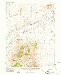
 1958 Winnemucca1960 Print · USGSWinnemucca and the high peaks of the Sonoma Range are captured here in the late fifties, during a period of steady growth for this railroad crossroads. Researchers can trace the dual tracks of the Southern Pacific and Western Pacific or locate historic mining sites like Adelaide and the Harmony Mine.3 unique versions available
 - 1958 Map of Rose Creek, 1960 Print
 1958 Rose Creek1960 Print · USGSThe Humboldt River corridor and the Sonoma Range meet here during the late 1950s, a period defined by rail traffic and high-desert mining. Researchers can trace the dual lines of the Southern Pacific and Western Pacific, find the Auburn Mine, and locate the old settlement of Rose Creek.2 unique versions available
End of results
Showing maps 1-4 of 4
Top cities near Winnemucca
Top neighborhoods of Winnemucca
Frequently asked questions
- What are the different types of historical maps available for Winnemucca?
- What is the oldest map of Winnemucca?
- Where can I purchase historical maps of Winnemucca for my home or office?
- Where can I download high-res historical maps of Winnemucca?
- Are there historical topographic maps available for Winnemucca?
- Is there historical aerial imagery available for Winnemucca?
- Where are historical maps of Winnemucca sourced from?