1980s Maps of Tonopah, Nevada
Explore 3 historic maps of Tonopah from the 1980s. These maps offer a rare glimpse into what life looked like during the 1980s — showing old roads, neighborhoods, homes, and landmarks that have changed or disappeared over time.
Whether you're researching your family's past, planning a metal detecting trip, or studying how Tonopah's landscape evolved across the 1980s, these high-resolution maps are a powerful tool for exploring the history of this region.
- Focus on a specific era: All maps on this page are from the 1980s, giving you a focused view of this time period.
- See what’s changed: Compare century-old streets, trails, and buildings to today's modern landscape using overlays and satellite layers.
- Research with precision: Use these maps for genealogy, historical research, land use analysis, or educational projects.
- View, download, or print: Maps are fully viewable online in high resolution, and can be downloaded or printed for your own records.
Start exploring Tonopah's history through authentic maps from the 1980s. This is your window into the past.
Tonopah, NV maps
(3)- 1987 Map of Crescent Dunes
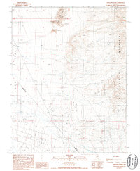 1987 Crescent Dunes1987 Print · USGSThe arid basins of Nye and Esmeralda counties are captured here in the late 1980s during a period of mineral exploration. Trace 4WD tracks to find numerous Prospects, a Corral, and the shifting Sand Dunes at the base of the San Antonio Mountains.
 - 1987 Map of Mt. Butte
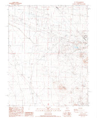 1987 Mt. Butte1987 Print · USGSMining activity and high-desert terrain define the border of Esmeralda and Nye counties during the late 1980s. Historians and mineral collectors can trace the location of the Hill of Gold Mine, an Old Railroad Grade, and numerous Prospects scattered near Siebert Mtn.
 - 1987 Map of Tonopah
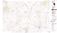 1987 Tonopah1987 Print · USGSThe mining heart of central Nevada is surveyed here in the late eighties, showing the specialized industrial landscape surrounding Tonopah. Researchers can trace early extraction sites like the Cinnabar Mine and defunct transportation routes along the Old Railroad Grade.2 unique versions available
End of results
Showing maps 1-3 of 3
Top neighborhoods of Tonopah
Frequently asked questions
- What are the different types of historical maps available for Tonopah?
- What is the oldest map of Tonopah?
- Where can I purchase historical maps of Tonopah for my home or office?
- Where can I download high-res historical maps of Tonopah?
- Are there historical topographic maps available for Tonopah?
- Is there historical aerial imagery available for Tonopah?
- Where are historical maps of Tonopah sourced from?