1900s (20th Century) Maps of Tybo, Nevada
Explore 6 historic maps of Tybo from the 1900s (20th Century). These maps offer a rare glimpse into what life looked like during the 1900s — showing old roads, neighborhoods, homes, and landmarks that have changed or disappeared over time.
Whether you're researching your family's past, planning a metal detecting trip, or studying how Tybo's landscape evolved across the 1900s, these high-resolution maps are a powerful tool for exploring the history of this region.
- Focus on a specific era: All maps on this page are from the 1900s, giving you a focused view of this time period.
- See what’s changed: Compare century-old streets, trails, and buildings to today's modern landscape using overlays and satellite layers.
- Research with precision: Use these maps for genealogy, historical research, land use analysis, or educational projects.
- View, download, or print: Maps are fully viewable online in high resolution, and can be downloaded or printed for your own records.
Start exploring Tybo's history through authentic maps from the 1900s. This is your window into the past.
Tybo, NV maps
(6)- 1956 Map of Tonopah, 1974 Print
 1956 Tonopah1974 Print · USGSCentral Nevada in the mid-fifties reveals a landscape shaped by mining and military footprints. Trace old silver districts near Tonopah and Manhattan, or locate early industrial sites like the Borax works at Columbus Salt Marsh.2 unique versions available
 - 1959 Map of Tonopah
 1959 Tonopah1959 Print · USGSCentral Nevada in the late fifties is a landscape of high desert ranges and mining history. Trace the remnants of old boomtowns and industrial sites like Berlin, the Gold Hill Mill, and the Victory Tungsten Mine.2 unique versions available
 - 1962 Map of Tonopah
 1962 Tonopah1962 Print · USGSCentral Nevada's high desert mining country is captured here during the early sixties, showing the enduring footprint of the silver and gold rushes. Researchers can trace the decline of historic camps and locate industrial sites like the Tybo Mine, Victory Tungsten Mine, and the Mt. Moriah Cemetery.2 unique versions available
 - 1968 Map of Tybo, 1970 Print
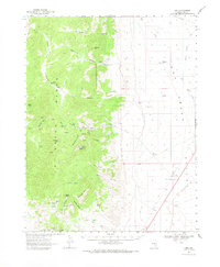 1968 Tybo1970 Print · USGSCentral Nevada in the late sixties reveals a landscape of high desert canyons and specialized mining. Trace the remnants of silver-era camps at Tybo and Keystone (Site), or locate the Central Nevada Test Site Base Camp and Charcoal Kilns.
 - 1968 Map of Tybo, 1973 Print
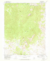 1968 Tybo1973 Print · USGSThe mining camp of Tybo and the surrounding peaks of the Hot Creek Range are captured here during the late 1960s. Researchers can trace historic industrial sites from the A & B Mine to the Charcoal Kilns used for processing local ore.2 unique versions available
 - 1987 Map of Warm Springs
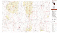 1987 Warm Springs1987 Print · USGSCentral Nevada in the late eighties remained a landscape of isolated mining camps and volcanic wonders. Genealogists and historians can trace the roads between Warm Springs and Tybo, or locate old workings like Ajax Mine and Clifford Mine.2 unique versions available
End of results
Showing maps 1-6 of 6
Frequently asked questions
- What are the different types of historical maps available for Tybo?
- What is the oldest map of Tybo?
- Where can I purchase historical maps of Tybo for my home or office?
- Where can I download high-res historical maps of Tybo?
- Are there historical topographic maps available for Tybo?
- Is there historical aerial imagery available for Tybo?
- Where are historical maps of Tybo sourced from?