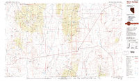
1987 Map of Warm Springs
USGS Topo · Published 1987About this map
Warm Springs serves as a central junction in this high-desert landscape of central Nevada, where the roads of Nye County converge amidst a series of north-south mountain ranges. This 1987 survey details a region defined by its mining legacy and geological curiosities, notably the volcanic features of the Pancake Range including the Lunar Crater, Lunar Cuesta, and The Wall. The map documents the scattered remnants of the area's mineral industry, from Kellys Mine in the Monitor Range to the Old Dominion and Empire workings further east. The vast basins of Stone Cabin Valley and Ralston Valley separate these highlands, while the Reveille Range features distinctive landmarks like the Goblin Knobs. Researchers will find a mix of high-altitude forest within the Toiyabe National Forest and arid lowlands such as Chuck Wagon Flat and Twin Springs Slough.
Find a feature on this map
48 named features on this map. Tap any name to fly to it.
Don’t see what you’re looking for? This feature index may not catch every label — zoom into the map to look around manually.
Map Details
Editions of this 1987 Warm Springs Map
2 editions found
Other maps of this area

1907 · Tonopah
USGS Topo · 1:250,000

1908 · Kawich
USGS Topo · 1:250,000

1908 · Lida
USGS Topo · 1:250,000

1908 · Tonopah
USGS Topo · 1:250,000

1913 · Lida
USGS Topo · 1:250,000

1942 · Cactus Range
USGS Topo · 1:125,000

1942 · Reveille Peak
USGS Topo · 1:125,000

1942 · Penoyer Valley
USGS Topo · 1:125,000

1945 · Goldfield
USGS Topo · 1:125,000

1952 · Stinking Spring
USGS Topo · 1:62,500