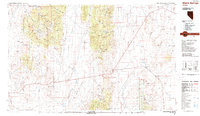
1987 Map of Warm Springs
USGS Topo · Published 1987About this map
Warm Springs serves as the central junction for this high-desert expanse of Nye County, situated where several valley systems and mountain ranges converge. The landscape is defined by the massive north-south corridors of West Stone Cabin Valley, East Stone Cabin Valley, and the Reveille Valley, bounded by the peaks of the Monitor Range and the Hot Creek Range. Evidence of Nevada's volcanic and mineral history is prominent, featuring geological landmarks like Lunar Crater and the curiously named Goblin Knobs. To the west, a portion of the Toiyabe National Forest covers the McKinney Mountains. Economic activity in the late twentieth century is represented by several distinct mining sites, including the Kellys Mine, Ajax Mine, and Clifford Mine, which are scattered throughout the hills and basins along the regional highway network.
Find a feature on this map
34 named features on this map. Tap any name to fly to it.
Don’t see what you’re looking for? This feature index may not catch every label — zoom into the map to look around manually.
Map Details
Editions of this 1987 Warm Springs Map
2 editions found
Other maps of this area

1907 · Tonopah
USGS Topo · 1:250,000

1908 · Kawich
USGS Topo · 1:250,000

1908 · Lida
USGS Topo · 1:250,000

1908 · Tonopah
USGS Topo · 1:250,000

1913 · Lida
USGS Topo · 1:250,000

1942 · Cactus Range
USGS Topo · 1:125,000

1942 · Reveille Peak
USGS Topo · 1:125,000

1942 · Penoyer Valley
USGS Topo · 1:125,000

1945 · Goldfield
USGS Topo · 1:125,000

1952 · Stinking Spring
USGS Topo · 1:62,500