1950s Maps of Warner, New Hampshire
Explore 5 historic maps of Warner from the 1950s. These maps offer a rare glimpse into what life looked like during the 1950s — showing old roads, neighborhoods, homes, and landmarks that have changed or disappeared over time.
Whether you're researching your family's past, planning a metal detecting trip, or studying how Warner's landscape evolved across the 1950s, these high-resolution maps are a powerful tool for exploring the history of this region.
- Focus on a specific era: All maps on this page are from the 1950s, giving you a focused view of this time period.
- See what’s changed: Compare century-old streets, trails, and buildings to today's modern landscape using overlays and satellite layers.
- Research with precision: Use these maps for genealogy, historical research, land use analysis, or educational projects.
- View, download, or print: Maps are fully viewable online in high resolution, and can be downloaded or printed for your own records.
Start exploring Warner's history through authentic maps from the 1950s. This is your window into the past.
Warner, NH maps
(5)- 1956 Map of Penacook, 1959 Print
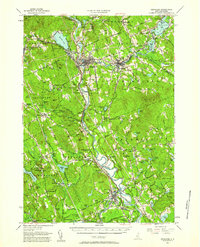 1956 Penacook1959 Print · USGSMerrimack County’s river valleys and rail lines are captured here in the mid-fifties, showing the industrial and civic hubs of Franklin and Penacook. Genealogists can locate family landmarks like Snyders Mill and Gerrish Corner or historic sites like the Daniel Webster Birthplace.3 unique versions available
 - 1956 Map of Mt. Kearsarge, 1959 Print
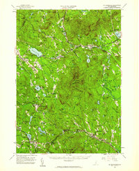 1956 Mt. Kearsarge1959 Print · USGSMerrimack County’s upland terrain and valley settlements are captured in the mid-1950s, showing the height of the region’s rail-and-resort character. Researchers can trace the Boston & Maine RR line through Potter Place and locate historic markers like Colby Jr College and Lake Massasecum.4 unique versions available
 - 1956 Map of Portland, 1963 Print
 1956 Portland1963 Print · USGSSouthern Maine and eastern New Hampshire are captured here in the mid-fifties, during a time of major highway expansion and military growth. You can trace the path of the Maine Turnpike and locate landmarks like the Portsmouth Naval Shipyard and Sebago Lake.4 unique versions available
 - 1957 Map of Hillsboro, 1960 Print
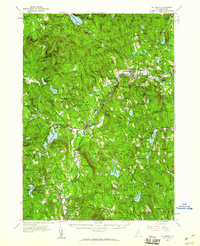 1957 Hillsboro1960 Print · USGSHillsborough County in the mid-fifties remains a landscape of river-powered mill towns and mountain forests. Researchers can trace the Boston and Maine rail corridor through Henniker and Hillsboro, or locate family sites near Donkey School and Maple Avenue Cemetery.3 unique versions available
 - 1959 Map of Portland
 1959 Portland1959 Print · USGSThe Maine and New Hampshire coastlines meet in this mid-century portrait of maritime commerce and inland rail networks. Researchers can trace the legacy of coastal defense at Fort Williams and follow the historic path of the Maine Central RR through the White Mountain National Forest.2 unique versions available
End of results
Showing maps 1-5 of 5
Top cities near Warner
- Concord historical maps
- Weare historical maps
- Franklin historical maps
- Bow historical maps
- Hopkinton historical maps
- Northfield historical maps
See more
Top neighborhoods of Warner
- Melvin Mills historical maps
- Roby historical maps
- Waterloo historical maps
- Davisville historical maps
- Bagley historical maps
- Dimond historical maps
See more
Frequently asked questions
- What are the different types of historical maps available for Warner?
- What is the oldest map of Warner?
- Where can I purchase historical maps of Warner for my home or office?
- Where can I download high-res historical maps of Warner?
- Are there historical topographic maps available for Warner?
- Is there historical aerial imagery available for Warner?
- Where are historical maps of Warner sourced from?