1960s Maps of Gloucester County, New Jersey
Explore 11 historic maps of Gloucester County from the 1960s. These maps offer a rare glimpse into what life looked like during the 1960s — showing old roads, neighborhoods, homes, and landmarks that have changed or disappeared over time.
Whether you're researching your family's past, planning a metal detecting trip, or studying how Gloucester County's landscape evolved across the 1960s, these high-resolution maps are a powerful tool for exploring the history of this region.
- Focus on a specific era: All maps on this page are from the 1960s, giving you a focused view of this time period.
- See what’s changed: Compare century-old streets, trails, and buildings to today's modern landscape using overlays and satellite layers.
- Research with precision: Use these maps for genealogy, historical research, land use analysis, or educational projects.
- View, download, or print: Maps are fully viewable online in high resolution, and can be downloaded or printed for your own records.
Start exploring Gloucester County's history through authentic maps from the 1960s. This is your window into the past.
Gloucester County, NJ maps
(11)- 1966 Map of Williamstown, 1968 Print
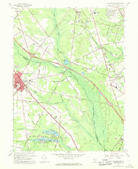 1966 Williamstown1968 Print · USGSSouth Jersey's shifting landscape is evident in the 1960s as major new arteries bisect traditional farming and rail communities. Genealogists and local historians can trace the footprint of Williamstown, Chesilhurst, and Sicklerville alongside landmarks like Hopewell Cem and St Johns Ch.3 unique versions available
 - 1966 Map of Pitman East, 1968 Print
 1966 Pitman East1968 Print · USGSMid-century Gloucester County comes into focus as the growth of Glassboro and its college meets the rural reaches of Monroe and Franklin. Researchers can trace the Pennsylvania-Reading Seashore Lines or locate family sites like Fries Mill and Hill Crest Memorial Park.3 unique versions available
 - 1966 Map of Wilmington, 1968 Print
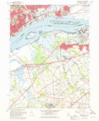
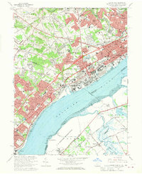
 1966 Wilmington1968 Print · USGSThe Delaware Valley and Jersey Shore are seen here in the mid-1960s, documenting a landscape of dense industrial cities and emerging coastal resorts. Researchers can trace the sprawling rail networks of the Pennsylvania Railroad or locate landmarks like Fort Dix Military Reservation and Elk Neck State Park.4 unique versions available
 - 1967 Map of Woodstown, 1968 Print
 1967 Woodstown1968 Print · USGSSalem and Gloucester counties were characterized by thriving rural townships and mill-based economies in the late sixties. Genealogists and historians can trace family locations near Mt Salem Ch, Porches Mill, and the early rail stops along the Pennsylvania-Reading Seashore Lines.2 unique versions available
 - 1967 Map of Runnemede, 1969 Print
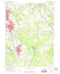
 1967 Runnemede1969 Print · USGSCamden and Gloucester Counties are shown in a phase of rapid postwar growth, where new expressways began to define the local landscape. Researchers can trace the development of suburban boroughs like Hi-Nella and Lawnside or locate the sprawling Lakeland General Hospital complex.4 unique versions available
 - 1967 Map of Bridgeport, 1969 Print
 1967 Bridgeport1969 Print · USGSIndustrial Pennsylvania meets rural New Jersey across the Delaware River in the late sixties. Genealogists and local historians can trace legacy sites like Crozer Seminary, St Josephs Cem, and the old Repaupo Station.4 unique versions available
 - 1967 Map of Woodbury, 1969 Print
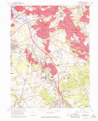
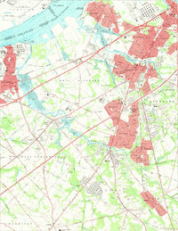 1967 Woodbury1969 Print · USGSGloucester County during the late sixties shows a landscape of growing suburbs and riverfront industry tied together by the Pennsylvania Reading Seashore Lines. Genealogists can locate family landmarks like Eglington Cemetery, Underwood Hospital, and the County Institution.4 unique versions available
 - 1967 Map of Penns Grove, 1969 Print
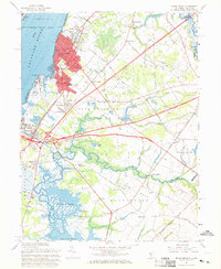 1967 Penns Grove1969 Print · USGSThe riverfront of Salem County is captured here in the late sixties as industrial hubs and suburban manors expanded alongside the historic Delaware. Trace family roots at Perkintown Cem, the St James Ch, or the small settlement of Marshalltown.2 unique versions available
 - 1967 Map of Pitman West, 1969 Print
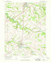
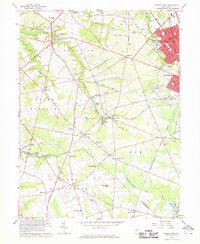 1967 Pitman West1969 Print · USGSGloucester County was a landscape of orchard-rich townships and growing rail-connected boroughs during the late sixties. Genealogists can trace family roots through historic landmarks like Wrights Mill, Siloam Ch, and the many hamlets from Mullica Hill to Monroeville.3 unique versions available
 - 1967 Map of Marcus Hook, 1970 Print
 1967 Marcus Hook1970 Print · USGSThe industrial corridor of the Delaware River transitions into the established suburbs of Pennsylvania and Delaware during the late sixties. Researchers can trace historic landmarks like the St Patricks Monastery, the grounds of Archmere Prep Sch, and the rail junctions of the Baltimore and Ohio.3 unique versions available
 - 1967 Map of Philadelphia, 1970 Print
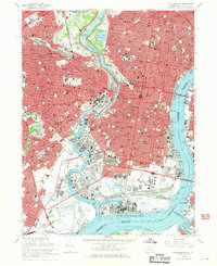 1967 Philadelphia1970 Print · USGSPhiladelphia's mid-century urban landscape is preserved here as the city adapted to new expressways and industrial shifts. Researchers can trace historic parish boundaries and landmarks like Girard College, Mt Moriah Cemetery, and the State Hospital for the Insane.6 unique versions available
End of results
Showing maps 1-11 of 11
Top cities of Gloucester County
- Washington Township historical maps
- Monroe Township historical maps
- Deptford Township historical maps
- West Deptford Township historical maps
- Glassboro historical maps
- Mantua Township historical maps
See more
Frequently asked questions
- What are the different types of historical maps available for Gloucester County?
- What is the oldest map of Gloucester County?
- Where can I purchase historical maps of Gloucester County for my home or office?
- Where can I download high-res historical maps of Gloucester County?
- Are there historical topographic maps available for Gloucester County?
- Is there historical aerial imagery available for Gloucester County?
- Where are historical maps of Gloucester County sourced from?