Old Maps of Gloucester County, New Jersey for Hiking & Exploration
Hike through history with 136 historic maps of Gloucester County. Explore old trails, ghost towns, and forgotten backroads — perfect for outdoor adventurers and local explorers.
- Rediscover forgotten places: Map out old mining camps, roads, and footpaths that no longer exist on modern maps.
- Layer with modern tools: Combine with LiDAR or satellite views to plan hikes through historical terrain.
- Made for exploration: Popular among hikers, overlanders, and local history lovers.
Use these maps to find adventure and explore the hidden past of Gloucester County.
Gloucester County, NJ maps
(136)- 1890 Map of Hammonton
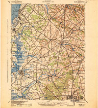
 1890 Hammonton1890 Print · USGSThe South Jersey Pine Barrens emerge in the late nineteenth century as a complex network of rail lines and agrarian outposts. Genealogists and local historians can trace the foundations of Hammonton, Williamstown, and vanished stops like Banzard Station and New Germany.
 - 1890 Map of Salem
 1890 Salem1890 Print · USGSSouth Jersey at the height of the Victorian era is captured here, showing the dense network of rail lines and creek-side landings. Genealogists and historians can trace family-named sites like Avis Mills, Hancock's Bridge, and Sharptown.2 unique versions available
 - 1890 Map of Glassboro
 1890 Glassboro1890 Print · USGSSouth Jersey was a thriving network of rail-side towns and mills in the late nineteenth century. Genealogists and historians can trace family roots through settlements like Pitman Grove or locate long-standing industry at Ewan's Mills and Frie's Mill.2 unique versions available
 - 1891 Map of Philadelphia
 1891 Philadelphia1891 Print · USGSPhiladelphia and its New Jersey neighbors are captured in the late Victorian era as rail and river commerce defined the region. Genealogists and historians can trace family-named sites and vanished river features like Windmill Island, Haddonfield, and the U.S. Navy Yard.
 - 1894 Map of Hammonton
 1894 Hammonton1894 Print · USGSHammonton and the surrounding Pine Barrens appear here in the late nineteenth century as a thriving agricultural and railroad crossroads. Genealogists and historians can trace early property hubs like the Fruit Growers Union, industrial sites such as Pancoast Mill, and the rail junctions at Winslow Junction.
 - 1894 Map of Chester, 1954 Print
 1894 Chester1954 Print · USGSThe Delaware River corridor near Chester was a hive of rail activity and water-powered industry at the close of the century. Genealogists and historians can trace family-named mills such as Llewellyn Mills or visit the campus of the Williamson School and the borough of Media.2 unique versions available
 - 1894 Map of Philadelphia, 1958 Print
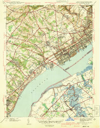
 1894 Philadelphia1958 Print · USGSPhiladelphia and Camden are shown at the height of the Victorian era, characterized by dense rail corridors and a bustling maritime waterfront. Genealogists and researchers can trace 19th-century neighborhoods and landmarks like Fort Mifflin, Paschallville, and the Alms House.
 - 1896 Map of Philadelphia
 1896 Philadelphia1896 Print · USGSPhiladelphia and its South Jersey neighbors appear at a peak of late-nineteenth-century industrial and maritime expansion. Genealogists and historians can trace the early layouts of Woodbury and Gloucester, or locate landmarks like Fort Mifflin and the U.S. Navy Yard along the riverfront.
 - 1896 Map of Chester
 1896 Chester1896 Print · USGSThe industrial corridor along the Delaware River thrives at the close of the nineteenth century as railroads and mills reshape the landscape. Genealogists can trace early homesteads and institutions like the Williamson School, Sharon Academy, and Sycamore Mills.
 - 1898 Map of Salem
 1898 Salem1898 Print · USGSSouthwestern New Jersey at the close of the nineteenth century shows a complex web of rural river settlements and early rail junctions. Trace the paths of the West Jersey and Seashore railroad and locate historical sites like Berry Chapel or Avis Mills.4 unique versions available
 - 1898 Map of Glassboro
 1898 Glassboro1898 Print · USGSSouthern New Jersey's rail-and-river network is frozen in time just before the turn of the century. Trace family roots and vanished depots through Glassboro, the crossroads at Elmer, and the winding Maurice River during this era of rapid growth.6 unique versions available
 - 1898 Map of Chester
 1898 Chester1898 Print · USGSThe Delaware River shoreline at the end of the nineteenth century reveals a landscape of industrial riverfronts and emerging mill towns. Genealogists and historians can trace family roots through numerous small settlements and institutions like Village Green, Booth Corner, and the Williamson School.10 unique versions available
 - 1898 Map of Philadelphia
 1898 Philadelphia1898 Print · USGSPhiladelphia and Camden emerge as a Victorian-era industrial powerhouse at the turn of the century, knit together by ferry and rail. Researchers can trace ancestral roots in vanished neighborhoods like Paschallville or locate landmarks like the Alms House and Fort Mifflin.9 unique versions available
 - 1898 Map of Hammonton
 1898 Hammonton1898 Print · USGSAtlantic and Camden counties are captured here in the late nineteenth century as the Pine Barrens were transformed by fruit farming and a massive rail network. Researchers can trace the legacy of early industry and transport at Fruit Growers Union, Winslow Junction, and the historic Waterford Works.3 unique versions available
 - 1900 Map of Rancocas
 1900 Rancocas1900 Print · USGSSouthern New Jersey at the turn of the century reveals a land of timber, mills, and emerging rail junctions. Genealogists and historians can trace the locations of family-owned landmarks like Jennings Mill, Ballingers Mill, and early settlements such as Colemantown and Fellowship.2 unique versions available
 - 1901 Map of Camden
 1901 Camden1901 Print · USGSThe Delaware River valley at the turn of the century shows a bustling corridor of early industrial growth and established mill towns. Researchers can trace the heritage of local industry at Sycamore Mills or locate early settlements like Penns Grove and Village Green.3 unique versions available
 - 1919 Map of Hammonton
 1919 Hammonton1919 Print · USGSThe Pine Barrens of the early twentieth century are defined here by a massive web of competing railroads and small mill settlements. Researchers can trace historic family landmarks and transit hubs like Winslow Junction, Iron Mills, and Pestletown during the region's peak agricultural era.
 - 1920 Map of Philadelphia
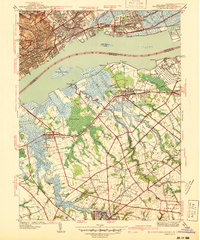
 1920 Philadelphia1920 Print · USGSPhiladelphia and its New Jersey neighbors are captured here just after the Great War, showing a landscape defined by massive riverfront industry and a dense rail network. Genealogists can trace family footprints through numerous small communities and stations like Blenheim Station, Woodbury Heights, and the grounds of the Alms House.
 - 1940 Map of Bridgeport
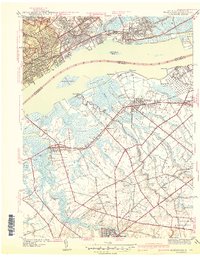
 1940 Bridgeport1940 Print · USGSThe industrial Delaware River waterfront and the rural truck farms of Gloucester County meet at the start of the 1940s. Researchers can trace family sites at Oaklawn Cem, follow the rail lines to Repaupo Sta, and see the footprint of the Locomotive Works.
 - 1941 Map of Marcus Hook
 1941 Marcus Hook1941 Print · USGSThe industrial and maritime riverfront at the start of the 1940s is captured here, showing the dense rail networks of the Marcus Hook area. Researchers can trace ancestral property near Hambys Corner, Siloam Ch, or the U S Military Reservation.
 - 1941 Map of Salem
 1941 Salem1941 Print · USGSSalem County and the Delaware River waterfront appear here in the early 1940s, just as industrial and wartime infrastructure began to reshape the landscape. Genealogists and local historians can trace family roots through old landmarks like Porches Mill, Yorktown PO, and the Wilmington Ferry route.
 - 1941 Map of Bridgeport
 1941 Bridgeport1941 Print · USGSThe Delaware River waterfront near Chester and Bridgeport was a hub of transit and industry in the early 1940s. Genealogists and historians can trace family locations through St Michael Cem, Oak Grove Sch, and the residential blocks of Westinghouse Village.
 - 1942 Map of Camden
 1942 Camden1942 Print · USGSThe Philadelphia and Camden metropolitan corridor is captured here at the height of the Second World War. Genealogists and historians can trace rail networks like the Reading R.R. and locate communities from Swedesboro to Merchantville.
 - 1942 Map of Hammonton
 1942 Hammonton1942 Print · USGSAtlantic and Camden counties come alive in the early 1940s, showing the South Jersey Pinelands just as the modern highway system began to overlap the old rail networks. Trace historical property lines and local hubs like Winslow Junction, Blue Anchor, and the waters of Hammonton Lake.
 - 1943 Map of Philadelphia
 1943 Philadelphia1943 Print · USGSPhiladelphia and Camden are shown at their wartime peak, anchored by the industrial activity of the Delaware River waterfront. Genealogists and historians can trace rail-connected neighborhoods and landmarks like the U. S. Navy Yard, Fort Mifflin, and the Alms House.
Showing maps 1-25 of 136
Top cities of Gloucester County
- Washington Township historical maps
- Monroe Township historical maps
- Deptford Township historical maps
- West Deptford Township historical maps
- Glassboro historical maps
- Mantua Township historical maps
See more
Frequently asked questions
- What are the different types of historical maps available for Gloucester County?
- What is the oldest map of Gloucester County?
- Where can I purchase historical maps of Gloucester County for my home or office?
- Where can I download high-res historical maps of Gloucester County?
- Are there historical topographic maps available for Gloucester County?
- Is there historical aerial imagery available for Gloucester County?
- Where are historical maps of Gloucester County sourced from?