1990s Maps of Gloucester County, New Jersey
Explore 9 historic maps of Gloucester County from the 1990s. These maps offer a rare glimpse into what life looked like during the 1990s — showing old roads, neighborhoods, homes, and landmarks that have changed or disappeared over time.
Whether you're researching your family's past, planning a metal detecting trip, or studying how Gloucester County's landscape evolved across the 1990s, these high-resolution maps are a powerful tool for exploring the history of this region.
- Focus on a specific era: All maps on this page are from the 1990s, giving you a focused view of this time period.
- See what’s changed: Compare century-old streets, trails, and buildings to today's modern landscape using overlays and satellite layers.
- Research with precision: Use these maps for genealogy, historical research, land use analysis, or educational projects.
- View, download, or print: Maps are fully viewable online in high resolution, and can be downloaded or printed for your own records.
Start exploring Gloucester County's history through authentic maps from the 1990s. This is your window into the past.
Gloucester County, NJ maps
(9)- 1993 Map of Marcus Hook
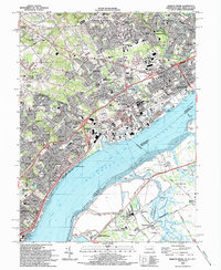 1993 Marcus Hook1993 Print · USGSThe Delaware River shoreline at Marcus Hook and Chester is captured here in the early nineties during its peak industrial era. Researchers can trace neighborhood growth near Archmere Academy and locate family landmarks like Immaculate Heart Ch & Cem.2 unique versions available
 - 1993 Map of Penns Grove
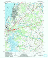 1993 Penns Grove1993 Print · USGSThe Delaware River shoreline at Penns Grove and Carneys Point is captured here in the early nineties. Genealogists can locate family landmarks like Bethel Ch and Marshalltown or trace the Wilmington & Northern Branch rail line.
 - 1995 Map of Woodbury, 1999 Print
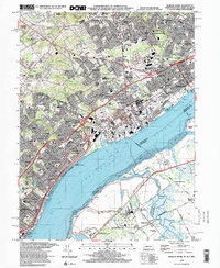
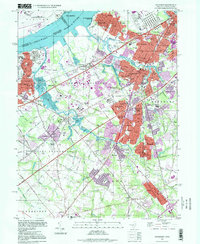 1995 Woodbury1999 Print · USGSGloucester County at the close of the twentieth century shows a landscape of established suburban boroughs and major riverfront industry. You can trace family roots through numerous local landmarks, including Eglington Cemetery, the County Institution, and Gateway Regional High School.
 - 1995 Map of Pitman West, 1999 Print
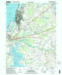
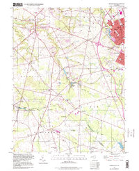 1995 Pitman West1999 Print · USGSGloucester County in the mid-nineties shows a mix of growing suburban centers and traditional rural crossroads. Researchers can trace historic family locations near Wrights Mill and Jessups Mill or locate old community landmarks like Mt Calvary Ch and Rodgers Sch.
 - 1995 Map of Philadelphia, 1999 Print
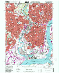 1995 Philadelphia1999 Print · USGSPhiladelphia at the close of the twentieth century remains a dense landscape of historic neighborhoods and industrial riverfronts. Genealogists and historians can trace parish boundaries and burial grounds like Old Cathedral Cemetery or locate landmarks such as Independence Hall and the U S Naval Shipyard.
 - 1995 Map of Bridgeport, 1999 Print
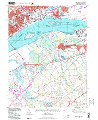 1995 Bridgeport1999 Print · USGSThe Delaware River waterfront near the turn of the millennium shows a landscape defined by heavy industry and critical transportation links. Researchers can trace historic local sites like Solomons Graveyard, the Seaplane Base, and the Bridgeport Airport during a period of significant regional change.
 - 1995 Map of Penns Grove, 1999 Print
 1995 Penns Grove1999 Print · USGSThe riverfront and rail corridors of Salem County are captured here in the mid-1990s, showcasing the transition from industrial Penns Grove to tidal marshlands. Genealogists and local historians can trace family sites at Perkintown Cem, Marshalltown, and Biddles Landing.
 - 1995 Map of Runnemede, 2000 Print
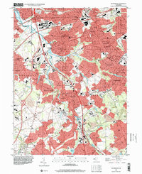 1995 Runnemede2000 Print · USGSCamden and Gloucester counties are shown here in the mid-nineties as the suburban landscape fully integrated with major regional thoroughfares. Researchers can trace historic neighborhoods and community anchors like Blackwood Terrace, St Johns Ch, and the Pennsylvania-Reading Seashore Lines.
 - 1995 Map of Marcus Hook, 2000 Print
 1995 Marcus Hook2000 Print · USGSThe industrial corridor and riverside towns of the tri-state border area appear in high detail during the late twentieth century. Genealogists and local historians can trace family roots through numerous sites like Greenlawn Cem, Archmere Academy, and the historic waterfront at Grubbs Landing.
End of results
Showing maps 1-9 of 9
Top cities of Gloucester County
- Washington Township historical maps
- Monroe Township historical maps
- Deptford Township historical maps
- West Deptford Township historical maps
- Glassboro historical maps
- Mantua Township historical maps
See more
Frequently asked questions
- What are the different types of historical maps available for Gloucester County?
- What is the oldest map of Gloucester County?
- Where can I purchase historical maps of Gloucester County for my home or office?
- Where can I download high-res historical maps of Gloucester County?
- Are there historical topographic maps available for Gloucester County?
- Is there historical aerial imagery available for Gloucester County?
- Where are historical maps of Gloucester County sourced from?