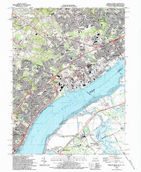
1993 Map of Marcus Hook
USGS Topo · Published 1993About this map
Marcus Hook stands as a focal point of industrial and maritime activity on the Delaware River during the early 1990s, where the Marcus Hook Range and Bellevue Range channels guide shipping traffic past the borough's shoreline seawall. The landscape reflects a dense intersection of residential life and heavy industry, with the Conrail rail lines and industrial waste ponds situated alongside established neighborhoods like Linwood and Trainer. This era shows a complex boundary of state and county lines, where Pennsylvania and Delaware meet near the Claymont station.
Find a feature on this map
155 named features on this map. Tap any name to fly to it.
Don’t see what you’re looking for? This feature index may not catch every label — zoom into the map to look around manually.
Map Details
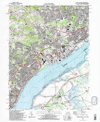
Editions of this 1993 Marcus Hook Map
2 editions found
Other maps of this area

1890 · Salem
USGS Topo · 1:62,500

1894 · Chester
USGS Topo · 1:62,500

1896 · Chester
USGS Topo · 1:62,500

1898 · Salem
USGS Topo · 1:62,500

1898 · Chester
USGS Topo · 1:62,500

1901 · Camden
USGS Topo · 1:125,000

1901 · West Chester
USGS Topo · 1:62,500

1904 · West Chester
USGS Topo · 1:62,500

1904 · Wilmington
USGS Topo · 1:62,500

1906 · Wilmington
USGS Topo · 1:62,500