1940s Maps of Kingwood Township, New Jersey
Explore 8 historic maps of Kingwood Township from the 1940s. These maps offer a rare glimpse into what life looked like during the 1940s — showing old roads, neighborhoods, homes, and landmarks that have changed or disappeared over time.
Whether you're researching your family's past, planning a metal detecting trip, or studying how Kingwood Township's landscape evolved across the 1940s, these high-resolution maps are a powerful tool for exploring the history of this region.
- Focus on a specific era: All maps on this page are from the 1940s, giving you a focused view of this time period.
- See what’s changed: Compare century-old streets, trails, and buildings to today's modern landscape using overlays and satellite layers.
- Research with precision: Use these maps for genealogy, historical research, land use analysis, or educational projects.
- View, download, or print: Maps are fully viewable online in high resolution, and can be downloaded or printed for your own records.
Start exploring Kingwood Township's history through authentic maps from the 1940s. This is your window into the past.
Kingwood Township, NJ maps
(8)- 1942 Map of Norristown
 1942 Norristown1942 Print · USGSSoutheastern Pennsylvania at the onset of World War II shows a landscape of busy industrial river towns and expanding rail suburbs. Genealogists and historians can trace the early transit networks connecting Norristown, Doylestown, and the riverfront at New Hope.
 - 1943 Map of Frenchtown
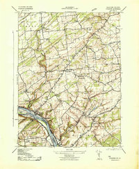
 1943 Frenchtown1943 Print · USGSThe Delaware River valley thrived as a rail and industrial corridor in the early 1940s. Genealogists can trace local roots through numerous landmarks like Frenchtown High School, Alexandria Cemetery, and Baptistown School.
 - 1943 Map of Stockton
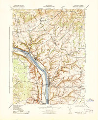
 1943 Stockton1943 Print · USGSHunterdon and Bucks counties are captured here in the early 1940s, highlighting the vital river-and-rail corridor along the New Jersey-Pennsylvania border. Researchers can trace old schoolhouses like Locktown School or locate industrial sites like the Stone Quarry and Delaware Canal.2 unique versions available
 - 1943 Map of Point Pleasant
 1943 Point Pleasant1943 Print · USGSMid-century Bucks and Hunterdon counties come alive through this survey of the river valley during the war years. Researchers can trace the Canal Feeder and railroad lines that defined the Delaware River corridor, or locate family landmarks like the Menonite Cemetery and Reading School.
 - 1943 Map of Bethlehem
 1943 Bethlehem1943 Print · USGSNorthampton and Lehigh counties hummed with industry and river commerce during the early war years. Researchers can trace the path of the Lehigh Valley RR, locate family-named landmarks like Chief Tatamy, and find rural schools such as Mexico School and Poplar Valley Sch.
 - 1943 Map of Cakepoulin Creek
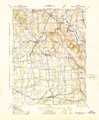 1943 Cakepoulin Creek1943 Print · USGSHunterdon County during the early war years reveals a landscape of established rail corridors and rural hamlets. Local historians can trace family locations near the Lehigh Valley line, the Oakgrove Grange Hall, and country schools like Jutland School.
 - 1944 Map of Newark, 1971 Print
 1944 Newark1971 Print · USGSThe industrial corridor from Philadelphia to New York was in a period of massive transition during the mid-forties. Genealogists and researchers can trace the rail lines of the Lehigh Valley RR, locate military installations like Picatinny Arsenal, and explore the early sprawl near Levittown.5 unique versions available
 - 1949 Map of Newark
 1949 Newark1949 Print · USGSThe industrial corridor between Philadelphia and New York comes alive in this post-war survey. Genealogists and historians can trace the massive rail networks of the Reading Railroad and locate major installations like Fort Dix or Picatinny Arsenal.2 unique versions available
End of results
Showing maps 1-8 of 8
Top cities near Kingwood Township
- Hillsborough Township historical maps
- Ewing Township historical maps
- Lower Makefield Township historical maps
- Easton historical maps
- Raritan Township historical maps
- Warrington Township historical maps
See more
Top neighborhoods of Kingwood Township
- Point Breeze historical maps
- Idell historical maps
- Byram historical maps
- Baptistown historical maps
- Milltown historical maps
- Tumble Falls historical maps
See more
Frequently asked questions
- What are the different types of historical maps available for Kingwood Township?
- What is the oldest map of Kingwood Township?
- Where can I purchase historical maps of Kingwood Township for my home or office?
- Where can I download high-res historical maps of Kingwood Township?
- Are there historical topographic maps available for Kingwood Township?
- Is there historical aerial imagery available for Kingwood Township?
- Where are historical maps of Kingwood Township sourced from?