1910s Maps of Ocean County, New Jersey
Explore 4 historic maps of Ocean County from the 1910s. These maps offer a rare glimpse into what life looked like during the 1910s — showing old roads, neighborhoods, homes, and landmarks that have changed or disappeared over time.
Whether you're researching your family's past, planning a metal detecting trip, or studying how Ocean County's landscape evolved across the 1910s, these high-resolution maps are a powerful tool for exploring the history of this region.
- Focus on a specific era: All maps on this page are from the 1910s, giving you a focused view of this time period.
- See what’s changed: Compare century-old streets, trails, and buildings to today's modern landscape using overlays and satellite layers.
- Research with precision: Use these maps for genealogy, historical research, land use analysis, or educational projects.
- View, download, or print: Maps are fully viewable online in high resolution, and can be downloaded or printed for your own records.
Start exploring Ocean County's history through authentic maps from the 1910s. This is your window into the past.
Ocean County, NJ maps
(4)- 1918 Map of Camp Dix
 1918 Camp Dix1918 Print · USGSNew Jersey at the height of the Great War features the sprawling mobilization grounds of Camp Dix and its expansive Rifle Range. Genealogists and historians can trace defunct stops like Imlaystown Sta or locate family roots near New Egypt and Colliers Mill.2 unique versions available
 - 1919 Map of Long Beach
 1919 Long Beach1919 Print · USGSThe New Jersey shore during the early twentieth century was a landscape of remote Life Saving Stations and emerging rail-side hamlets. Genealogists and historians can trace the early footprints of Beach Haven and Harvey Cedars along the Long Beach Railroad.
 - 1919 Map of Barnegat, 1921 Print
 1919 Barnegat1921 Print · USGSCoastal Ocean County comes alive in the years after the Great War, showing a landscape of barrier island settlements and mainland rail stops. Genealogists and historians can trace early shore life through the string of Life Saving Stations, the Barnegat Light, and old rail stops like Pinewald Sta. or Ostrom Sta.
 - 1919 Map of Asbury Park, 1921 Print
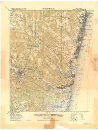 1919 Asbury Park1921 Print · USGSCoastal Monmouth and Ocean Counties come alive in the early twentieth century, showing the rapid growth of beach resorts alongside quiet pineland settlements. Researchers can trace the early rail corridors of the Pennsylvania Railroad and locate maritime landmarks like L.S. Station Manasquan Beach and Point Pleasant.
End of results
Showing maps 1-4 of 4
Top cities of Ocean County
- Toms River historical maps
- Lakewood Township historical maps
- Brick Township historical maps
- Jackson Township historical maps
- Manchester Township historical maps
- Berkeley Township historical maps
See more
Frequently asked questions
- What are the different types of historical maps available for Ocean County?
- What is the oldest map of Ocean County?
- Where can I purchase historical maps of Ocean County for my home or office?
- Where can I download high-res historical maps of Ocean County?
- Are there historical topographic maps available for Ocean County?
- Is there historical aerial imagery available for Ocean County?
- Where are historical maps of Ocean County sourced from?