1950s Maps of Ocean County, New Jersey
Explore 40 historic maps of Ocean County from the 1950s. These maps offer a rare glimpse into what life looked like during the 1950s — showing old roads, neighborhoods, homes, and landmarks that have changed or disappeared over time.
Whether you're researching your family's past, planning a metal detecting trip, or studying how Ocean County's landscape evolved across the 1950s, these high-resolution maps are a powerful tool for exploring the history of this region.
- Focus on a specific era: All maps on this page are from the 1950s, giving you a focused view of this time period.
- See what’s changed: Compare century-old streets, trails, and buildings to today's modern landscape using overlays and satellite layers.
- Research with precision: Use these maps for genealogy, historical research, land use analysis, or educational projects.
- View, download, or print: Maps are fully viewable online in high resolution, and can be downloaded or printed for your own records.
Start exploring Ocean County's history through authentic maps from the 1950s. This is your window into the past.
Ocean County, NJ maps
(40)- 1951 Map of Keswick Grove
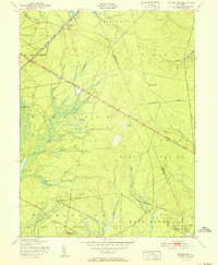
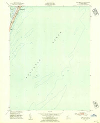
 1951 Keswick Grove1951 Print · USGSThe New Jersey Pine Barrens appear in the early fifties as a landscape of cranberry bogs, timber, and isolated rail junctions. Genealogists and researchers can trace the routes of the Central Railroad of New Jersey and locate sites like Dover Forge, Keswick Grove, and the Clay Pits.
 - 1951 Map of Woodmansie
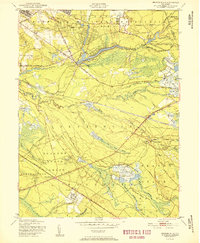
 1951 Woodmansie1951 Print · USGSThe New Jersey Pine Barrens are captured here in the early fifties, showing a landscape of state forests and specialized agriculture. Researchers can trace the Central Railroad of New Jersey through Woodmansie or locate old Cranberry Bogs and the Coyle Airport.2 unique versions available
 - 1951 Map of Browns Mills
 1951 Browns Mills1951 Print · USGSMid-century Burlington County is defined here by military expansion and the agricultural heritage of the Pine Barrens. Researchers can trace historic industrial sites and unique settlements like Whitesbog, Ongs Hat, and the specialized Cranberry Bogs of the region.
 - 1951 Map of West Creek
 1951 West Creek1951 Print · USGSOcean County in the early fifties shows a landscape of coastal wetlands and pine forests before the era of heavy development. Genealogists can locate specific homesteads and family sites near Staffordville, Mayetta, and the Cedar Run Cem.5 unique versions available
 - 1951 Map of Brookville
 1951 Brookville1951 Print · USGSThe New Jersey Pine Barrens appear in their mid-century quietude here, showing the intersection of Lacey and Ocean townships. Genealogists and historians can trace the early footprints of Brookville, Warren Grove, and the industrial site at Wells Mill.
 - 1951 Map of Whiting
 1951 Whiting1951 Print · USGSThe New Jersey Pine Barrens are captured here at mid-century, defined by the heavy rail corridors of the Pennsylvania Railroad and military lands. Researchers can trace the layout of Whiting, follow the network of Cranberry Bogs, and locate remote sites like Pasadena and Bullock.
 - 1951 Map of New Gretna, 1954 Print
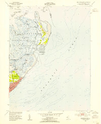
 1951 New Gretna1954 Print · USGSThe coastal wetlands of Burlington and Atlantic counties are captured here in the early fifties, just as the Garden State Parkway was being built. Genealogists can trace family lines near New Gretna, Port Republic, and the Hillside Cem.7 unique versions available
 - 1951 Map of Beach Haven, 1954 Print
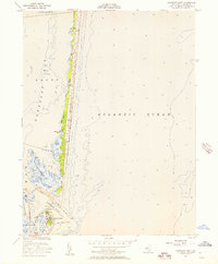
 1951 Beach Haven1954 Print · USGSThe Jersey Shore comes alive in the early fifties on this detailed survey of Long Beach. Trace the dense grid of coastal settlements from Brant Beach down to Beach Haven, and locate harbor landmarks like Mordecai Island and Peahala Park.4 unique versions available
 - 1951 Map of Long Beach NE, 1954 Print
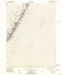
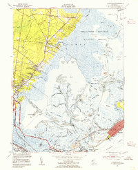
 1951 Long Beach NE1954 Print · USGSCoastal New Jersey at the start of the 1950s reveals the early mid-century footprint of the northern barrier islands. Researchers can trace the street grid of Barnegat Light, locate Long Beach Park, and study the soundings between Barnegat Bay and the ocean.4 unique versions available
 - 1952 Map of Brigantine Inlet, 1954 Print
 1952 Brigantine Inlet1954 Print · USGSCoastal New Jersey is captured in the early fifties during a pivotal era of shoreline development and conservation. Genealogists and local historians can trace the early streets of Brigantine, find the 14th Street Pier, and explore the marshes of the Brigantine National Wildlife Refuge.4 unique versions available
 - 1952 Map of Tuckerton, 1954 Print
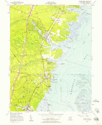
 1952 Tuckerton1954 Print · USGSCoastal New Jersey in the early fifties reveals a landscape of tidal marshes and quiet seaside boroughs before the era of major development. Researchers can trace family roots through Greenwood Cem or locate industrial sites like the Fish Factory and Cranberry Bogs.6 unique versions available
 - 1952 Map of Ship Bottom, 1954 Print
 1952 Ship Bottom1954 Print · USGSThe Jersey Shore comes alive in this early 1950s survey of the barrier island and bay marshes during a period of steady coastal growth. Genealogists and historians can trace the street grids of Surf City, Ship Bottom, and Harvey Cedars or locate the Transatlantic Radio Receiver station.5 unique versions available
 - 1952 Map of Oceanville, 1955 Print
 1952 Oceanville1955 Print · USGSThe Atlantic County shoreline in the early fifties reveals a landscape of tidal marshes and growing coastal towns. Genealogists and historians can trace family-named routes like Leeds Point Road or locate landmarks such as the Seaview Country Club and Lily Lake.3 unique versions available
 - 1953 Map of Barnegat Light, 1957 Print
 1953 Barnegat Light1957 Print · USGSThe Jersey Shore in the early fifties reveals a landscape of shifting sands and maritime markers along Island Beach. Trace the coastal infrastructure surrounding the Lighthouse and the Sedge Islands, where the settlement of Barnegat Light meets the sea.3 unique versions available
 - 1953 Map of Point Pleasant, 1957 Print
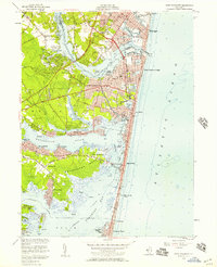 1953 Point Pleasant1957 Print · USGSThe Jersey Shore is shown during the early 1950s, capturing the detailed layout of coastal towns and tidal estuaries. Local historians can trace family roots through landmarks like White Lawn Cem, the Bay Head Junction rail hub, and Cranberry Bogs.4 unique versions available
 - 1953 Map of Seaside Park, 1957 Print
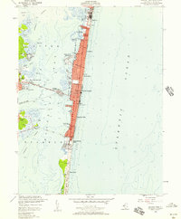 1953 Seaside Park1957 Print · USGSThe Jersey Shore emerges in its mid-century form along the narrow barrier between Barnegat Bay and the ocean. Tracing the coast reveals the early footprint of Seaside Heights, the Boardwalk, and the southern expanse of Island Beach State Park.3 unique versions available
 - 1953 Map of Toms River, 1958 Print
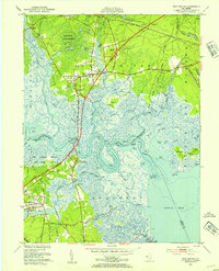
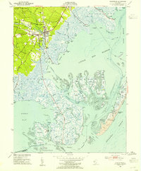
 1953 Toms River1958 Print · USGSThe Barnegat Bay shoreline and the emerging Garden State Parkway corridor define this mid-century survey of coastal Ocean County. Researchers can trace the layout of early vacation communities like Island Heights and Ocean Gate alongside inland landmarks like the Admiral Farragut Academy and the Cranberry Bogs near Double Trouble.3 unique versions available
 - 1953 Map of Forked River, 1958 Print
 1953 Forked River1958 Print · USGSCoastal Ocean County comes alive in the 1950s, showing the early rise of the Garden State Parkway alongside the Central RR of New Jersey. Genealogists and historians can trace family ties at the Good Luck Cem or Old Waretown Cem.3 unique versions available
 - 1954 Map of New York
 1954 New York1954 Print · USGSLong Island and the New York metropolitan area are shown during the height of post-war suburbanization. Genealogists and historians can trace the growth of Levittown, the infrastructure of the Long Island Rail Road, and landmarks like Mitchel Afb.2 unique versions available
 - 1954 Map of Farmingdale
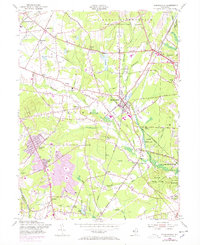 1954 Farmingdale1954 Print · USGSMonmouth County during the mid-fifties shows a landscape of military reservations and expanding suburban residential tracts. Trace family history and local landmarks through the Southard Ch, the Drive-in Theater, and the sprawling Earle Ammunition Depot.6 unique versions available
 - 1954 Map of Asbury Park, 1956 Print
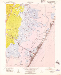
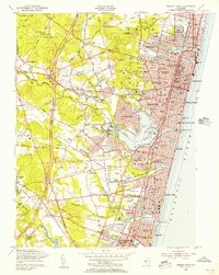 1954 Asbury Park1956 Print · USGSThe Jersey Shore is shown in its mid-century prime, featuring the bustling boardwalks and emerging suburban corridors of the 1950s. Genealogists and local historians can locate specific borough landmarks like Fitkin Memorial Hospital, Wall Stadium, and the Asbury Park Air Terminal.5 unique versions available
 - 1954 Map of Lakewood, 1956 Print
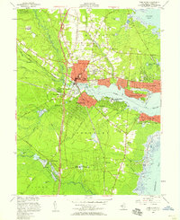
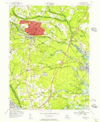 1954 Lakewood1956 Print · USGSMid-century Ocean County is captured during a period of growth, centered on the historic resort community of Lakewood and its surrounding townships. Researchers can trace family sites and local institutions through landmarks like Georgian Court College, Seven Stars, and the Mt Sinai Cem.3 unique versions available
 - 1955 Map of Wilmington
 1955 Wilmington1955 Print · USGSThe Delaware Valley and Jersey Shore are seen here during the mid-fifties era of rapid suburban expansion and highway development. You can trace the path of the New Jersey Turnpike, locate the Fort Dix Military Reservation, or explore the rail networks of the Pennsylvania Railroad.
 - 1955 Map of Oswego Lake, 1956 Print
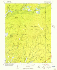 1955 Oswego Lake1956 Print · USGSIn the mid-fifties, this Pine Barrens landscape was a mix of state forests and new federal military installations. Genealogists and historians can trace old homesteads and crossings at Leektown, Sim Place, and Bartletts Bridge amidst the sprawling Penn State Forest.4 unique versions available
 - 1956 Map of Newark
 1956 Newark1956 Print · USGSThe industrial heart of the Mid-Atlantic is captured here at the dawn of the highway era, tracing the dense corridors between Newark and Philadelphia. Genealogists and local historians can map the rail networks of the Reading RR or locate mid-century military life at Fort Dix Military Reservation.2 unique versions available
Showing maps 1-25 of 40
Top cities of Ocean County
- Toms River historical maps
- Lakewood Township historical maps
- Brick Township historical maps
- Jackson Township historical maps
- Manchester Township historical maps
- Berkeley Township historical maps
See more
Frequently asked questions
- What are the different types of historical maps available for Ocean County?
- What is the oldest map of Ocean County?
- Where can I purchase historical maps of Ocean County for my home or office?
- Where can I download high-res historical maps of Ocean County?
- Are there historical topographic maps available for Ocean County?
- Is there historical aerial imagery available for Ocean County?
- Where are historical maps of Ocean County sourced from?