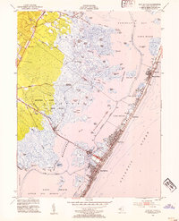
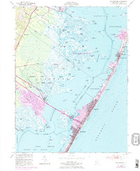
1952 Map of Ship Bottom
USGS Topo · Published 1954About this map
Long Beach barrier island serves as the focal point of this coastal survey, detailing the early 1950s development of shore communities from Ship Bottom and Surf City north to Harvey Cedars and High Point. This era shows the island before the modern bridge infrastructure fully transformed the coastline, with Long Beach Blvd connecting the narrow residential grids. Across the bay, the landscape remains largely undeveloped marshland and salt meadow, dominated by the Manahawkin Hunting and Fishing Grounds and a network of tidal waters like the Gunning River and Big Flat Creek.
Find a feature on this map
77 named features on this map. Tap any name to fly to it.
Don’t see what you’re looking for? This feature index may not catch every label — zoom into the map to look around manually.
Map Details
Editions of this 1952 Ship Bottom Map
5 editions found
Other maps of this area

1884 · Whitings
USGS Topo · 1:62,500

1888 · Barnegat
USGS Topo · 1:62,500

1888 · Little Egg Harbor
USGS Topo · 1:62,500

1888 · Long Beach
USGS Topo · 1:62,500

1888 · Whitings
USGS Topo · 1:62,500

1893 · Little Egg Harbor
USGS Topo · 1:62,500

1893 · Long Beach
USGS Topo · 1:62,500

1893 · Barnegat
USGS Topo · 1:62,500

1898 · Barnegat
USGS Topo · 1:62,500

1919 · Long Beach
USGS Topo · 1:62,500
Featured Places
- Stafford Township, NJ
- Barnegat Township, NJ
- Long Beach Township, NJ
- Eagleswood Township, NJ
- Surf City, NJ