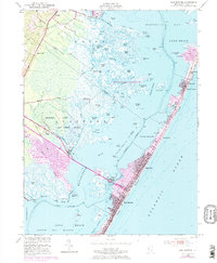
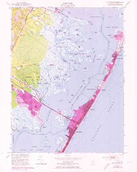
1952 Map of Ship Bottom
USGS Topo · Published 1973About this map
Long Beach island and the coastal wetlands of Manahawkin Bay define this mid-century look at Ocean County's barrier shore. The map records a period of transition as inland developments like Beach Haven West and Frazier Park began to expand alongside established coastal boroughs. Much of the mainland remains dominated by the Barnegat National Wildlife Refuge and the Manahawkin Hunting and Fishing Grounds, a landscape of intricate tidal channels including Crooked Creek and Log Creek. Along the narrow peninsula, the growth of Ship Bottom, Surf City, and Harvey Cedars is documented, including technical infrastructure like the Transatlantic Radio Receiver. To the north, the smaller enclave of Loveladies sits near the marshes of Sloop Sedge, illustrating the varied pace of coastal settlement between the Atlantic and the bay.
Find a feature on this map
76 named features on this map. Tap any name to fly to it.
Don’t see what you’re looking for? This feature index may not catch every label — zoom into the map to look around manually.
Map Details
Editions of this 1952 Ship Bottom Map
5 editions found
Other maps of this area

1884 · Whitings
USGS Topo · 1:62,500

1888 · Barnegat
USGS Topo · 1:62,500

1888 · Little Egg Harbor
USGS Topo · 1:62,500

1888 · Long Beach
USGS Topo · 1:62,500

1888 · Whitings
USGS Topo · 1:62,500

1893 · Little Egg Harbor
USGS Topo · 1:62,500

1893 · Long Beach
USGS Topo · 1:62,500

1893 · Barnegat
USGS Topo · 1:62,500

1898 · Barnegat
USGS Topo · 1:62,500

1919 · Long Beach
USGS Topo · 1:62,500
Featured Places
- Stafford Township, NJ
- Barnegat Township, NJ
- Long Beach Township, NJ
- Eagleswood Township, NJ
- Surf City, NJ