1940s Maps of Ocean County, New Jersey
Explore 28 historic maps of Ocean County from the 1940s. These maps offer a rare glimpse into what life looked like during the 1940s — showing old roads, neighborhoods, homes, and landmarks that have changed or disappeared over time.
Whether you're researching your family's past, planning a metal detecting trip, or studying how Ocean County's landscape evolved across the 1940s, these high-resolution maps are a powerful tool for exploring the history of this region.
- Focus on a specific era: All maps on this page are from the 1940s, giving you a focused view of this time period.
- See what’s changed: Compare century-old streets, trails, and buildings to today's modern landscape using overlays and satellite layers.
- Research with precision: Use these maps for genealogy, historical research, land use analysis, or educational projects.
- View, download, or print: Maps are fully viewable online in high resolution, and can be downloaded or printed for your own records.
Start exploring Ocean County's history through authentic maps from the 1940s. This is your window into the past.
Ocean County, NJ maps
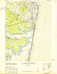
(28)- 1940 Map of Atlantic City, 1953 Print
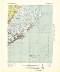
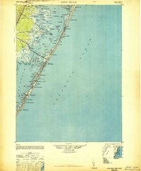
 1940 Atlantic City1953 Print · USGSThe New Jersey coastline during the pre-war era is mapped here in detail, showcasing the resort boom and rail connections of the day. Researchers can trace the layout of famous boardwalk landmarks like the Steel Pier and the Pennsylvania-Reading Seashore Lines into the city.
 - 1941 Map of Toms River
 1941 Toms River1941 Print · USGSCoastal New Jersey's riverfronts and barrier islands are captured here just before the mid-century boom. Trace historic family sites and early infrastructure at Double Trouble, Murray Grove Cemetery, and the Pinewald Golf Course.2 unique versions available
 - 1941 Map of Atlantic City
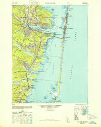
 1941 Atlantic City1941 Print · USGSAtlantic City and its neighboring shore towns are captured in the early 1940s, showing a world of grand boardwalk piers and intricate tidal marshlands. Trace the routes of the Pennsylvania-Reading Seashore Lines or locate landmarks like Absecon Light and the Heinz Pier.2 unique versions available
 - 1941 Map of Long Beach
 1941 Long Beach1941 Print · USGSLong Beach Island and the Jersey Shore appear here just before the mid-century, showing a string of coastal villages linked by the Pennsylvania Railroad. Genealogists and historians can trace property near Long Beach Township Hall or explore early bayside landmarks like Ship Bottom and Harvey Cedars.
 - 1942 Map of Whiting
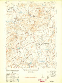
 1942 Whiting1942 Print · USGSThe Jersey Pine Barrens are captured here during the early years of the war, showing the region's transition between industry and military use. Genealogists and historians can trace old settlements like Woodmansie, early aviation at Coyle Field, and the rail junction at Whiting.2 unique versions available
 - 1942 Map of Tuckerton
 1942 Tuckerton1942 Print · USGSThe Jersey Shore and Pine Barrens meet here just as the coastal infrastructure was maturing before mid-century. Researchers can trace the layout of Tuckerton, locate the old Stafford Forge, and explore the maze of sedges in Little Egg Harbor.2 unique versions available
 - 1942 Map of Farmingdale
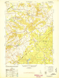
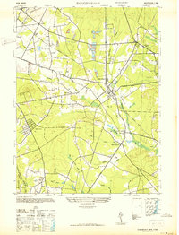 1942 Farmingdale1942 Print · USGSMonmouth County and the northern edge of Ocean County are shown here in the early 1940s during a period of industrial rail reliance. Trace the rail junctions at Farmingdale or locate historic settlements like Allaire, Squankum, and Jerseyville.
 - 1942 Map of Pemberton
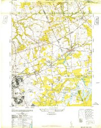
 1942 Pemberton1942 Print · USGSBurlington County during the early years of the war is caught between its deep industrial roots and new military mobilization. Researchers can trace historic iron sites like Mary Ann Furnace, family locations such as Sooy Place, and the rail lines serving Whitesbog.
 - 1944 Map of Jersey Homesteads
 1944 Jersey Homesteads1944 Print · USGSMonmouth and Ocean counties appear here during the mid-forties, capturing a landscape of rural hamlets and small mills. Researchers can trace the New Deal-era Jersey Homesteads and find ancestral sites like Francis Mills, Carrs Tavern, and Perrineville.
 - 1944 Map of Newark, 1971 Print
 1944 Newark1971 Print · USGSThe industrial corridor from Philadelphia to New York was in a period of massive transition during the mid-forties. Genealogists and researchers can trace the rail lines of the Lehigh Valley RR, locate military installations like Picatinny Arsenal, and explore the early sprawl near Levittown.5 unique versions available
 - 1946 Map of Wilmington, 1948 Print
 1946 Wilmington1948 Print · USGSThe Delaware Valley and Jersey Shore emerge in this mid-century portrait of a region defined by river commerce and seaside growth. Genealogists and historians can trace the rail networks of the Pennsylvania Railroad, locate early airfields like Dover Airpark, and find river defenses at Fort Delaware.2 unique versions available
 - 1947 Map of Lakewood
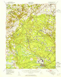
 1947 Lakewood1947 Print · USGSCoastal Ocean County in the late 1940s shows a mix of growing townships and pine-lined waterways just as the regional highway system expanded. Genealogists and historians can trace old residential grids in Lakewood, locate family plots at Evergreen Cem, or follow the Central Railroad of New Jersey.
 - 1947 Map of Lakehurst
 1947 Lakehurst1947 Print · USGSOcean County emerges as a strategic hub in the years following World War II, defined by military aviation and quiet woodland settlements. Researchers can trace the sprawling grounds of the US Naval Air Station, the local streets of Lakehurst, and the remote Newman Sch.2 unique versions available
 - 1947 Map of Asbury Park
 1947 Asbury Park1947 Print · USGSThe Jersey Shore thrives in this post-war survey, documenting the vibrant coastal stretch from Asbury Park down to Sea Girt. Family historians can trace local roots through numerous landmarks like Shafto Corners, Mt Prospect Cemetery, and the Bangs Ave Sch.
 - 1947 Map of Roosevelt
 1947 Roosevelt1947 Print · USGSCentral New Jersey's rural interior is captured here just after the war, showing the unique intersection of Monmouth, Mercer, and Ocean counties. Genealogists and local historians can trace family-named sites like Carrs Tavern, Holmeson, and the extensive Cranberry bogs near Prospertown.2 unique versions available
 - 1947 Map of Point Pleasant
 1947 Point Pleasant1947 Print · USGSThe Jersey Shore is captured here just after the war, showing the coastal communities from Manasquan down to Normandy Beach. Genealogists and local historians can trace the early layout of Point Pleasant, locate the Mantoloking Ch, or find the historic Life Saving Station Manasquan Beach.2 unique versions available
 - 1947 Map of Adelphia
 1947 Adelphia1947 Print · USGSMonmouth and Ocean Counties are captured here in the late 1940s, showing a landscape defined by industry and agriculture before major suburbanization. Trace the footprints of early mill sites like Jacksons Mills and Wyckoff Mills, or the extensive cranberry bogs along the Manasquan River.2 unique versions available
 - 1948 Map of Cassville
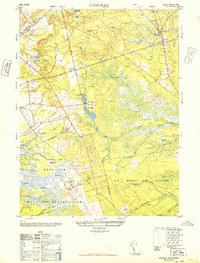 1948 Cassville1948 Print · USGSMid-century Ocean County was a landscape of Pinelands agriculture and expanding military reservations. You can trace the footprint of early industry through numerous Cranberry bogs, a Dismantled Railroad, and settlements like Cassville and Archers Corner.2 unique versions available
 - 1948 Map of Long Beach
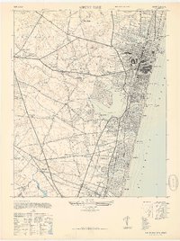
 1948 Long Beach1948 Print · USGSLong Beach Island is shown in the late 1940s as a series of growing seaside communities and strategic maritime stations. Researchers can trace the early layout of Surf City, Beach Haven, and the Harvey Cedars CG 115 coast guard facility.3 unique versions available
 - 1948 Map of Roosevelt
 1948 Roosevelt1948 Print · USGSMonmouth County rural life is captured in the late 1940s, showing the early days of the Roosevelt colony and established hamlets. Genealogists can trace family landmarks and crossroads like Stone Tavern, Clarksburg, and the numerous Cranberry bogs near Prospertown.
 - 1948 Map of New Egypt
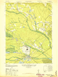
 1948 New Egypt1948 Print · USGSPost-war Burlington and Ocean counties are defined here by a massive military footprint and the traditional cranberry industry. Genealogists and historians can trace the early layouts of New Egypt and Wrightstown or locate family landmarks like Cranberry Hall.3 unique versions available
 - 1948 Map of Toms River
 1948 Toms River1948 Print · USGSThe Jersey Shore's mid-century landscape is preserved here, from the mainland settlements of Toms River to the narrow barrier of Island Beach. Genealogists can trace family landmarks like the Friends Meeting Cemetery and Murray Grove Cemetery as the coastal rail lines linked the bay towns.6 unique versions available
 - 1948 Map of Lakehurst, 1954 Print
 1948 Lakehurst1954 Print · USGSPost-war central New Jersey comes to life here, showing the rural landscapes of Ocean and Monmouth counties before major suburbanization. Trace the footprints of the U S Naval Air Station and historic mill towns like Jacksons Mills and Cassville.2 unique versions available
 - 1948 Map of Bordentown, 1954 Print
 1948 Bordentown1954 Print · USGSCentral New Jersey stands at the crossroads of military expansion and early highway development in the years following the war. Genealogists and historians can trace the rural layouts of Bordentown and New Egypt or locate landmarks like Arneys Mount and the Pa Maritime Academy.2 unique versions available
 - 1949 Map of Newark
 1949 Newark1949 Print · USGSThe industrial corridor between Philadelphia and New York comes alive in this post-war survey. Genealogists and historians can trace the massive rail networks of the Reading Railroad and locate major installations like Fort Dix or Picatinny Arsenal.2 unique versions available
Showing maps 1-25 of 28
Top cities of Ocean County
- Toms River historical maps
- Lakewood Township historical maps
- Brick Township historical maps
- Jackson Township historical maps
- Manchester Township historical maps
- Berkeley Township historical maps
See more
Frequently asked questions
- What are the different types of historical maps available for Ocean County?
- What is the oldest map of Ocean County?
- Where can I purchase historical maps of Ocean County for my home or office?
- Where can I download high-res historical maps of Ocean County?
- Are there historical topographic maps available for Ocean County?
- Is there historical aerial imagery available for Ocean County?
- Where are historical maps of Ocean County sourced from?