1990s Maps of Warren Township, New Jersey
Explore 3 historic maps of Warren Township from the 1990s. These maps offer a rare glimpse into what life looked like during the 1990s — showing old roads, neighborhoods, homes, and landmarks that have changed or disappeared over time.
Whether you're researching your family's past, planning a metal detecting trip, or studying how Warren Township's landscape evolved across the 1990s, these high-resolution maps are a powerful tool for exploring the history of this region.
- Focus on a specific era: All maps on this page are from the 1990s, giving you a focused view of this time period.
- See what’s changed: Compare century-old streets, trails, and buildings to today's modern landscape using overlays and satellite layers.
- Research with precision: Use these maps for genealogy, historical research, land use analysis, or educational projects.
- View, download, or print: Maps are fully viewable online in high resolution, and can be downloaded or printed for your own records.
Start exploring Warren Township's history through authentic maps from the 1990s. This is your window into the past.
Warren Township, NJ maps
(3)- 1995 Map of Bound Brook, 1998 Print
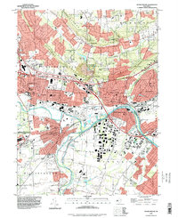 1995 Bound Brook1998 Print · USGSMid-century New Jersey comes into focus here, centered on the busy industrial and rail corridors where the Raritan River meets the historic Delaware and Raritan Canal. Researchers can trace old neighborhoods and cultural sites like Zarephath, the Ukrainian Village, and Alma White College.
 - 1995 Map of Plainfield, 1998 Print
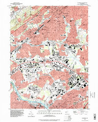 1995 Plainfield1998 Print · USGSThe industrial corridor and residential expansion of Central New Jersey are captured here in the mid-1990s. Researchers can trace the rail heritage of the Pennsylvania RR or locate landmarks like Rutgers University and Washington Rock State Park.
 - 1995 Map of Chatham, 2000 Print
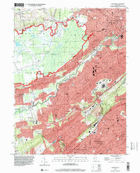 1995 Chatham2000 Print · USGSNorthern New Jersey's suburban landscape and conservation lands are captured here during the mid-1990s, from the Great Swamp to the Watchung Mountains. Local researchers can trace school and parish history at Fairmount Ave Sch or St Josephs Villa while surveying the Southern Division rail line.
End of results
Showing maps 1-3 of 3
Top cities near Warren Township
- Edison historical maps
- Woodbridge Township historical maps
- Franklin Township historical maps
- Old Bridge Township historical maps
- Union historical maps
- Parsippany-Troy Hills historical maps
See more
Top neighborhoods of Warren Township
- Warrenville historical maps
- Round Top historical maps
- Smalleytown historical maps
- Coontown historical maps
- Mount Horeb historical maps
- Mount Bethel historical maps
See more
Frequently asked questions
- What are the different types of historical maps available for Warren Township?
- What is the oldest map of Warren Township?
- Where can I purchase historical maps of Warren Township for my home or office?
- Where can I download high-res historical maps of Warren Township?
- Are there historical topographic maps available for Warren Township?
- Is there historical aerial imagery available for Warren Township?
- Where are historical maps of Warren Township sourced from?