1950s Maps of Warren Township, New Jersey
Explore 6 historic maps of Warren Township from the 1950s. These maps offer a rare glimpse into what life looked like during the 1950s — showing old roads, neighborhoods, homes, and landmarks that have changed or disappeared over time.
Whether you're researching your family's past, planning a metal detecting trip, or studying how Warren Township's landscape evolved across the 1950s, these high-resolution maps are a powerful tool for exploring the history of this region.
- Focus on a specific era: All maps on this page are from the 1950s, giving you a focused view of this time period.
- See what’s changed: Compare century-old streets, trails, and buildings to today's modern landscape using overlays and satellite layers.
- Research with precision: Use these maps for genealogy, historical research, land use analysis, or educational projects.
- View, download, or print: Maps are fully viewable online in high resolution, and can be downloaded or printed for your own records.
Start exploring Warren Township's history through authentic maps from the 1950s. This is your window into the past.
Warren Township, NJ maps
(6)- 1954 Map of Bernardsville, 1956 Print
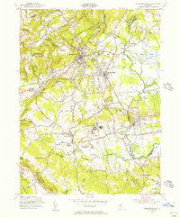 1954 Bernardsville1956 Print · USGSThe Somerset and Morris County borderlands come into focus in the mid-1950s, showing a landscape of established estates and growing townships. Genealogists and historians can trace local landmarks like Somerset Hills Cemetery, the U S Veterans Hospital, and Osborn Mills.6 unique versions available
 - 1955 Map of Plainfield, 1957 Print
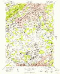 1955 Plainfield1957 Print · USGSMid-century New Jersey comes to life as industrial rail corridors and the sprawling US Military Reservation Camp Kilmer meet expanding suburbs. Trace early flight at Hadley Airport and local roots at Sacred Heart Sch or Pumptown.5 unique versions available
 - 1955 Map of Bound Brook, 1957 Print
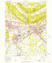 1955 Bound Brook1957 Print · USGSSomerset County undergoes rapid post-war growth in the mid-fifties as industry and infrastructure converge along the Raritan. Researchers can trace the path of the Delaware and Raritan Canal or locate local landmarks like Alma White College and the Van Nest Burying Ground.5 unique versions available
 - 1955 Map of Chatham, 1957 Print
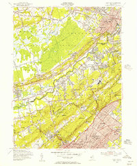 1955 Chatham1957 Print · USGSMid-century Morris, Somerset, and Union Counties are defined here by the intersection of the Great Swamp and the rising Watchung Mountains. Researchers can trace the development of suburban rail corridors and find local landmarks like St Josephs Shrine, Meyersville Cem, and the Watchung Reservation.7 unique versions available
 - 1956 Map of Newark
 1956 Newark1956 Print · USGSThe industrial heart of the Mid-Atlantic is captured here at the dawn of the highway era, tracing the dense corridors between Newark and Philadelphia. Genealogists and local historians can map the rail networks of the Reading RR or locate mid-century military life at Fort Dix Military Reservation.2 unique versions available
 - 1957 Map of Newark
 1957 Newark1957 Print · USGSThe industrial and military heart of the Mid-Atlantic is mapped during its post-war suburban boom. Genealogists and historians can trace the intricate rail corridors of the Reading Railroad and locate key landmarks from Princeton University to Fort Hancock.
End of results
Showing maps 1-6 of 6
Top cities near Warren Township
- Edison historical maps
- Woodbridge Township historical maps
- Franklin Township historical maps
- Old Bridge Township historical maps
- Union historical maps
- Parsippany-Troy Hills historical maps
See more
Top neighborhoods of Warren Township
- Warrenville historical maps
- Round Top historical maps
- Smalleytown historical maps
- Coontown historical maps
- Mount Horeb historical maps
- Mount Bethel historical maps
See more
Frequently asked questions
- What are the different types of historical maps available for Warren Township?
- What is the oldest map of Warren Township?
- Where can I purchase historical maps of Warren Township for my home or office?
- Where can I download high-res historical maps of Warren Township?
- Are there historical topographic maps available for Warren Township?
- Is there historical aerial imagery available for Warren Township?
- Where are historical maps of Warren Township sourced from?