1940s Maps of Carlsbad, New Mexico
Explore 3 historic maps of Carlsbad from the 1940s. These maps offer a rare glimpse into what life looked like during the 1940s — showing old roads, neighborhoods, homes, and landmarks that have changed or disappeared over time.
Whether you're researching your family's past, planning a metal detecting trip, or studying how Carlsbad's landscape evolved across the 1940s, these high-resolution maps are a powerful tool for exploring the history of this region.
- Focus on a specific era: All maps on this page are from the 1940s, giving you a focused view of this time period.
- See what’s changed: Compare century-old streets, trails, and buildings to today's modern landscape using overlays and satellite layers.
- Research with precision: Use these maps for genealogy, historical research, land use analysis, or educational projects.
- View, download, or print: Maps are fully viewable online in high resolution, and can be downloaded or printed for your own records.
Start exploring Carlsbad's history through authentic maps from the 1940s. This is your window into the past.
Carlsbad, NM maps
(3)- 1943 Map of Carlsbad
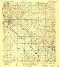 1943 Carlsbad1943 Print · USGSThe Pecos Valley during the early 1940s reveals a unique network of irrigation flumes and potash industrial sites. Researchers can trace family-named landmarks and rural infrastructure like Forehand Ranch, Harroun Sch, and the U S Potash Co Refinery.
 - 1943 Map of West Carlsbad, 1964 Print
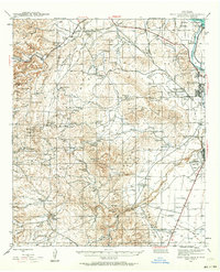 1943 West Carlsbad1964 Print · USGSEddy County ranchlands and military installations come alive in this mid-century survey of the Pecos River valley. Genealogists and historians can trace family operations at Lovejoy Ranch and Kee Ranch, or locate the Golden Eagle Mine and the Carlsbad Army Air Field.2 unique versions available
 - 1945 Map of West Carlsbad
 1945 West Carlsbad1945 Print · USGSEddy County ranching and military aviation meet in the mid-1940s as the Pecos River valley expands. Researchers can locate numerous historic homesteads like Lovejoy Ranch, the high-elevation Golden Eagle Mine, and the wartime Army Air Field.
End of results
Showing maps 1-3 of 3
Top cities near Carlsbad
Top neighborhoods of Carlsbad
Frequently asked questions
- What are the different types of historical maps available for Carlsbad?
- What is the oldest map of Carlsbad?
- Where can I purchase historical maps of Carlsbad for my home or office?
- Where can I download high-res historical maps of Carlsbad?
- Are there historical topographic maps available for Carlsbad?
- Is there historical aerial imagery available for Carlsbad?
- Where are historical maps of Carlsbad sourced from?