1980s Maps of Carlsbad, New Mexico
Explore 4 historic maps of Carlsbad from the 1980s. These maps offer a rare glimpse into what life looked like during the 1980s — showing old roads, neighborhoods, homes, and landmarks that have changed or disappeared over time.
Whether you're researching your family's past, planning a metal detecting trip, or studying how Carlsbad's landscape evolved across the 1980s, these high-resolution maps are a powerful tool for exploring the history of this region.
- Focus on a specific era: All maps on this page are from the 1980s, giving you a focused view of this time period.
- See what’s changed: Compare century-old streets, trails, and buildings to today's modern landscape using overlays and satellite layers.
- Research with precision: Use these maps for genealogy, historical research, land use analysis, or educational projects.
- View, download, or print: Maps are fully viewable online in high resolution, and can be downloaded or printed for your own records.
Start exploring Carlsbad's history through authentic maps from the 1980s. This is your window into the past.
Carlsbad, NM maps
(4)- 1985 Map of Kitchen Cove
 1985 Kitchen Cove1985 Print · USGSEddy County ranchlands and energy fields are captured here during the mid-eighties as the region balanced aviation and resource extraction. Researchers can trace land use through features like the Sheep Draw Aqueduct, Yellow Jacket Spring, and the Carlsbad Cavern City Air Terminal.
 - 1985 Map of Otis
 1985 Otis1985 Print · USGSThe outskirts of Carlsbad and the rural community of Otis are captured in the mid-1980s as a landscape shaped by water and industry. Researchers can trace the engineering of the Southern Canal and locate specific sites like the local Radio Facility or regional Gravel Pits.
 - 1985 Map of Carlsbad East
 1985 Carlsbad East1985 Print · USGSMid-century development in Eddy County shows the desert transformed by the oil industry and river irrigation. Genealogists and historians can trace the growth of Carlsbad and La Huerta alongside the Carlsbad Oil Field and the Pecos River.
 - 1985 Map of Carlsbad West
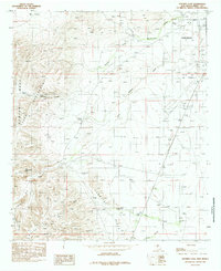
 1985 Carlsbad West1985 Print · USGSThe western reaches of the Pecos River valley are documented here in the mid-eighties as urban growth begins to climb into the nearby hills. Local researchers can trace residential developments like Happy Valley or locate old water sources like Mc Kitric Spring and Mc Gruder Spring.2 unique versions available
End of results
Showing maps 1-4 of 4
Top cities near Carlsbad
Top neighborhoods of Carlsbad
Frequently asked questions
- What are the different types of historical maps available for Carlsbad?
- What is the oldest map of Carlsbad?
- Where can I purchase historical maps of Carlsbad for my home or office?
- Where can I download high-res historical maps of Carlsbad?
- Are there historical topographic maps available for Carlsbad?
- Is there historical aerial imagery available for Carlsbad?
- Where are historical maps of Carlsbad sourced from?