1910s Maps of High Lonesome Wells, New Mexico
Explore 2 historic maps of High Lonesome Wells from the 1910s. These maps offer a rare glimpse into what life looked like during the 1910s — showing old roads, neighborhoods, homes, and landmarks that have changed or disappeared over time.
Whether you're researching your family's past, planning a metal detecting trip, or studying how High Lonesome Wells's landscape evolved across the 1910s, these high-resolution maps are a powerful tool for exploring the history of this region.
- Focus on a specific era: All maps on this page are from the 1910s, giving you a focused view of this time period.
- See what’s changed: Compare century-old streets, trails, and buildings to today's modern landscape using overlays and satellite layers.
- Research with precision: Use these maps for genealogy, historical research, land use analysis, or educational projects.
- View, download, or print: Maps are fully viewable online in high resolution, and can be downloaded or printed for your own records.
Start exploring High Lonesome Wells's history through authentic maps from the 1910s. This is your window into the past.
High Lonesome Wells, NM maps
(2)- 1917 Map of Antelope Wells, 1970 Print
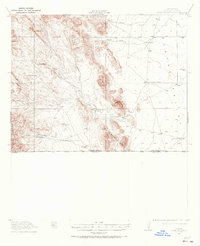 1917 Antelope Wells1970 Print · USGSThe New Mexico and Mexico border region comes alive in this 1917 survey of ranching outposts and mountain passes. Researchers can trace family-named sites like Culberson's Ranch and Lynch Ranch, alongside vital desert water sources including Antelope Wells.2 unique versions available
 - 1919 Map of Antelope Wells
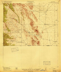 1919 Antelope Wells1919 Print · USGSThe New Mexico borderlands come into focus at the end of the Great War, showing a landscape of remote cattle ranches and vital desert water sources. Researchers can trace historic family-named sites like Culbersons Ranch and W.H.Sims Ranch or follow the old Packers Trail.2 unique versions available
End of results
Showing maps 1-2 of 2
Frequently asked questions
- What are the different types of historical maps available for High Lonesome Wells?
- What is the oldest map of High Lonesome Wells?
- Where can I purchase historical maps of High Lonesome Wells for my home or office?
- Where can I download high-res historical maps of High Lonesome Wells?
- Are there historical topographic maps available for High Lonesome Wells?
- Is there historical aerial imagery available for High Lonesome Wells?
- Where are historical maps of High Lonesome Wells sourced from?